
Seemingly simple question: I have a KMZ file with mesh objects in its placemark folder, I need to get these written to a shapefile. Any ideas? I tried a GeometryCoercer, no luck.

Solved
Turning a mesh into a polygon

 +63
+63Best answer by takashi
Hi @redgeographics, the data contains a feature which has a MultiSurface geometry consisting of two Mesh geometries. A possible way is:
- Deaggregator: MultiSurface -> individual Meshes
- GeometryCoercer (Geometry Type: fme_composite_surface): Meshes -> CompositeSurfaces
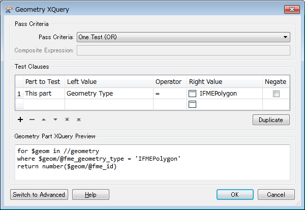
- GeometryPartExtractor: Extract polygon parts from the CompositeSurfaces, with this setting.
This post is closed to further activity.
It may be an old question, an answered question, an implemented idea, or a notification-only post.
Please check post dates before relying on any information in a question or answer.
For follow-up or related questions, please post a new question or idea.
If there is a genuine update to be made, please contact us and request that the post is reopened.


Login to the community
No account yet? Create an account
An FME Account is required to contribute
LoginEnter your E-mail address. We'll send you an e-mail with instructions to reset your password.