When I use the Reprojector:
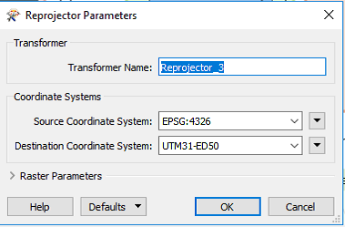
The coordinate system seems to be correct:
Coordinate System Parameters
CS_NAME: UTM31-ED50 DESC_NM: Universal Transverse Mercator Zone 31 North (Europ50) DT_NAME: EUROP50 GROUP: EUROPE MAP_SCL: 1 PARM1: 3 PROJ: TM QUAD: 1 SCL_RED: 0.9996 UNIT: METER X_OFF: 500000 Datum Parameters DELTA_X: -87 DELTA_Y: -98 DELTA_Z: -121 DESC_NM: European 1950, mean Values ELLIPSOID: INTNL SOURCE: US Defense Mapping Agency, TR-8350.2-B, December 1987 USE: MOLODENSKY Ellipsoid Parameters DESC_NM: International - 1924 E_RAD: 6378388 P_RAD: 6356911.9461279465 SOURCE: US Defense Mapping Agency, TR-8350.2-B, December 1987 OGC WKT Description PROJCS["Universal Transverse Mercator Zone 31 North (Europ50)", GEOGCS["ED50", DATUM["European_Datum_1950", SPHEROID["International - 1924",6378388,297.0000000000014, AUTHORITY["EPSG","7022"]], AUTHORITY["EPSG","6230"]], PRIMEM["Greenwich",0], UNIT["degree",0.0174532925199433], AUTHORITY["EPSG","4230"]], PROJECTION["Transverse_Mercator"], PARAMETER["latitude_of_origin",0], PARAMETER["central_meridian",3], PARAMETER["scale_factor",0.9996], PARAMETER["false_easting",500000], PARAMETER["false_northing",0], UNIT["METER",1]] Esri WKT Description PROJCS["Universal_Transverse_Mercator_Zone_31_North_Europ50",GEOGCS["GCS_European_1950",DATUM["D_European_1950",SPHEROID["International_1924",6378388,297.0]],PRIMEM["Greenwich",0],UNIT["Degree",0.017453292519943295]],PROJECTION["Transverse_Mercator"],PARAMETER["latitude_of_origin",0],PARAMETER["central_meridian",3],PARAMETER["scale_factor",0.9996],PARAMETER["false_easting",500000],PARAMETER["false_northing",0],UNIT["Meter",1]]However when I examine the data the data is off approx 3m in the x-direction.
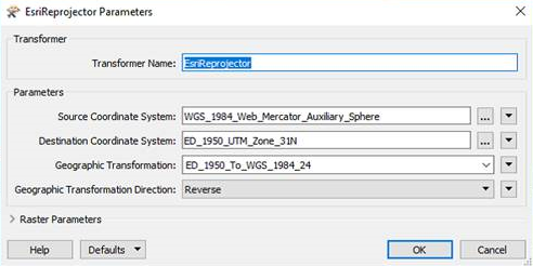
I try to use the ESRIReprojector instead selecting:

However when I then examine the coordinate system it seems to be the wrong one and in degrees rather than meter:
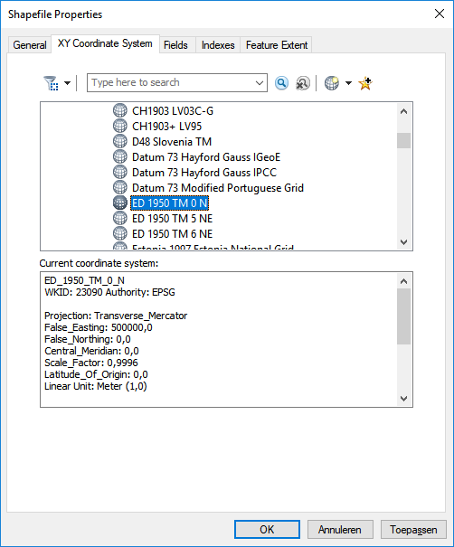
Coordinate System Parameters
CS_NAME: _LLERP50-W_0 DESC_NM: Lat/long referenced to European 1950 ala Multiple Regression DT_NAME: ERP50-W ESRI_WKT: GEOGCS["GCS_European_1950",DATUM["D_European_1950",SPHEROID["International_1924",6378388.0,297.0]],PRIMEM["Greenwich",0.0],UNIT["Degree",0.0174532925199433]] GROUP: LL MAP_SCL: 1 MAX_LAT: 90 MAX_LNG: 180 MIN_LAT: -90 MIN_LNG: -180 PROJ: LL QUAD: 1 SCL_RED: 1 SOURCE: Datum from DMA TR-8350.2-B UNIT: DEGREE ZERO_X: 1.0000000000000003e-9 ZERO_Y: 1.0000000000000003e-9 Datum Parameters DELTA_X: -87 DELTA_Y: -96 DELTA_Z: -120 DESC_NM: European 1950, Western Europe ELLIPSOID: INTNL SOURCE: US Defense Mapping Agency, TR-8350.2-B, December 1987 USE: MULREG Ellipsoid Parameters DESC_NM: International - 1924 E_RAD: 6378388 P_RAD: 6356911.9461279465 SOURCE: US Defense Mapping Agency, TR-8350.2-B, December 1987 OGC WKT Description GEOGCS["Lat/long referenced to European 1950 ala Multiple Regression", DATUM["European_Datum_1950_1977", SPHEROID["International - 1924",6378388,297.0000000000014]], PRIMEM["Greenwich",0], UNIT["degree",0.0174532925199433]] Esri WKT Description GEOGCS["GCS_European_1950",DATUM["D_European_1950",SPHEROID["International_1924",6378388.0,297.0]],PRIMEM["Greenwich",0.0],UNIT["Degree",0.0174532925199433]]It also gives an error in the logfile:
Coordinate system named _SPHERICAL_MERCATOR_1 does not exist.
But I can not seem to figure out the mistake. Any help?


")