Solved

Automating WFS download

  • February 21, 2018
  • 4 replies
  • 71 views

pflegpet
Contributor
Forum|alt.badge.img+8

Hi,

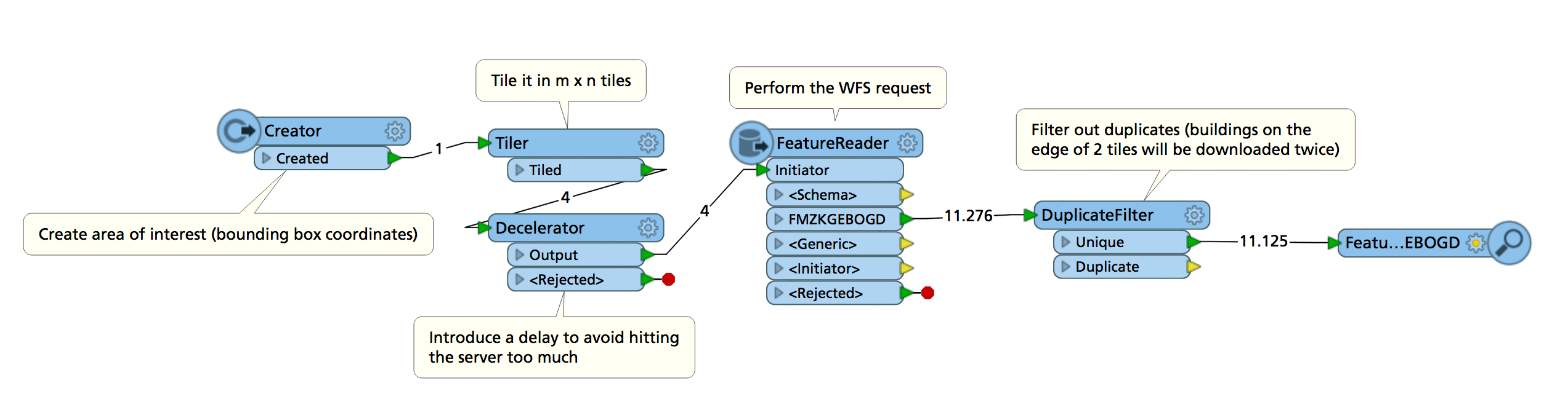
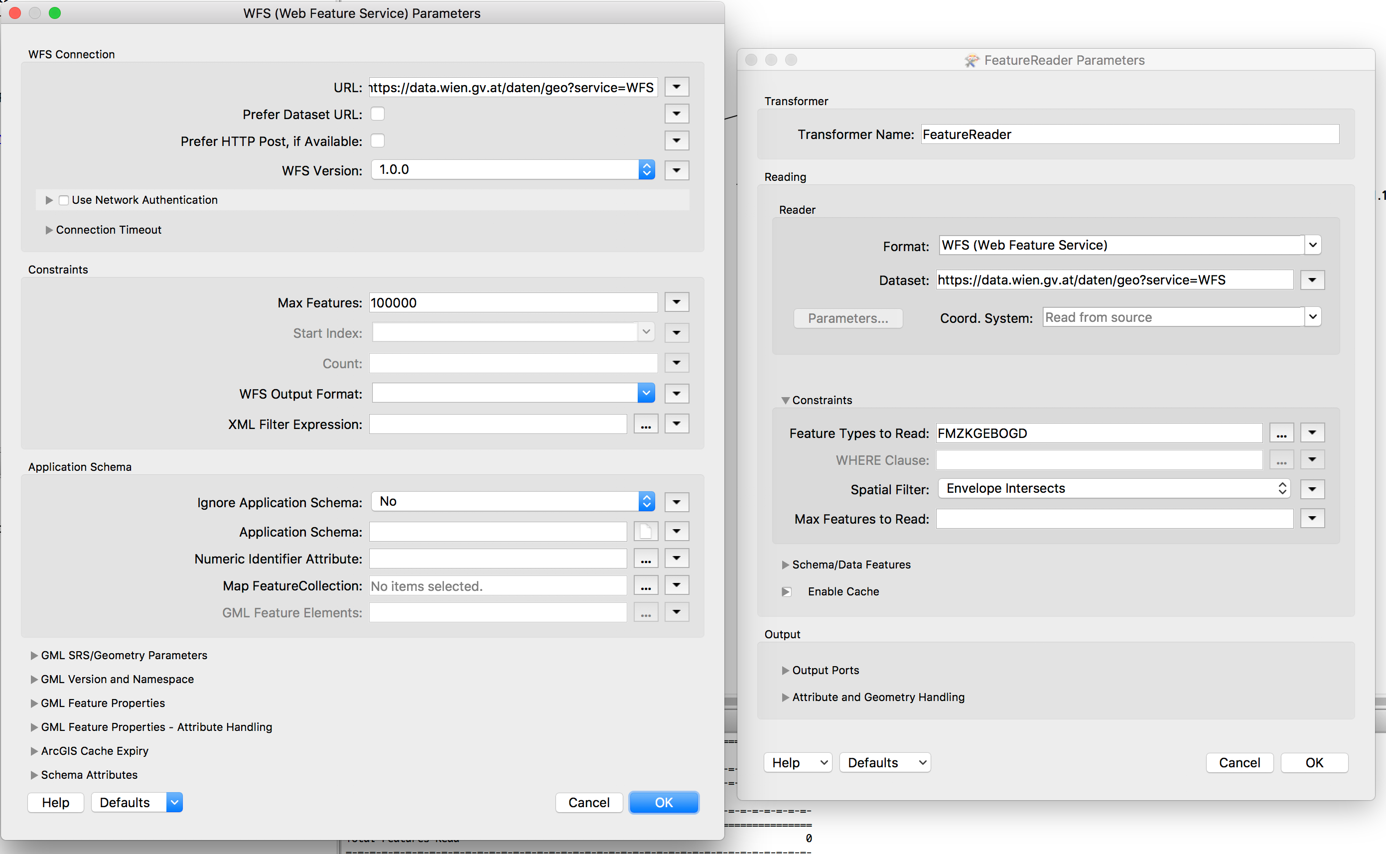
I would like to create a workflow to download and merge vector data from a WFS. The city of Vienna provides building footprints in shape format via WFS. Due to the large filesize it is recommended to reduce one download to a tile of 2x2 kilometers or smaller. As I need the complete dataset I try to create a workspace to download all tiles with getfeature requests (e.g. https://data.wien.gv.at/daten/geo?service=WFS&version;=1.0.0&request;=GetFeature&typeName;=ogdwien:FMZKGEBOGD&outputFormat;=shape-zip&SRS;=EPSG:31256&BBOX;=2748,341794,4516,343209) and then merge the tiles into a File GDB. Is it possible to dynamically create the request by inserting the necessary bounding box coordinates and then merge data directly out of a ZIP file. Thanks for any help.

Best answer by redgeographics

If you use the FeatureReader with tiles as input you don't need to worry about inserting coordinates into the request.

The FeatureReader is set up like this:

Note that the max features setting does apply, so make sure you set it high enough (I tried a 2 x 2 km section near the Hofburg and that yields only 11000 buildings, in tests I've put that parameter as high up as 200000 without maxing out).

The Spatial Filter setting of Envelope Intersects will automatically apply the bounding box of the Initiator to the request.

View original
Did this help you find an answer to your question?

4 replies

redgeographics
Celebrity
Forum|alt.badge.img+50
  • Celebrity
  • Best Answer
  • February 21, 2018

If you use the FeatureReader with tiles as input you don't need to worry about inserting coordinates into the request.

The FeatureReader is set up like this:

Note that the max features setting does apply, so make sure you set it high enough (I tried a 2 x 2 km section near the Hofburg and that yields only 11000 buildings, in tests I've put that parameter as high up as 200000 without maxing out).

The Spatial Filter setting of Envelope Intersects will automatically apply the bounding box of the Initiator to the request.


pflegpet
Contributor
Forum|alt.badge.img+8
  • Author
  • Contributor
  • February 21, 2018
redgeographics wrote:

If you use the FeatureReader with tiles as input you don't need to worry about inserting coordinates into the request.

The FeatureReader is set up like this:

Note that the max features setting does apply, so make sure you set it high enough (I tried a 2 x 2 km section near the Hofburg and that yields only 11000 buildings, in tests I've put that parameter as high up as 200000 without maxing out).

The Spatial Filter setting of Envelope Intersects will automatically apply the bounding box of the Initiator to the request.

Awesome, thank you for your detailed answer. Would you mind sharing the workspace? I could use some help setting up the creator as I never used it before.


redgeographics
Celebrity
Forum|alt.badge.img+50
pflegpet wrote:
Awesome, thank you for your detailed answer. Would you mind sharing the workspace? I could use some help setting up the creator as I never used it before.


Here you go: none2none.fmw


pflegpet
Contributor
Forum|alt.badge.img+8
  • Author
  • Contributor
  • February 21, 2018
redgeographics wrote:
Here you go: none2none.fmw


Thank you! You just safed me a lot of time.


Reply


Cookie policy

We use cookies to enhance and personalize your experience. If you accept you agree to our full cookie policy. Learn more about our cookies.

 
Cookie settings