

In General
In general, this was a treasure hunt contest where you guessed at a treasure's location by adding pins to a virtual map. The winner was the closest pin to the actual treasure's location. Naturally, a series of clues were available to help you identify the location.
Puzzles
Clues were obtained by solving puzzles. There were 20 puzzles to solve in total, in 4 rows of 5 puzzles. Each puzzle gave you a location clue and a bonus clue to provide the meaning of those location clues.
| Puzzle Set | Puzzle Difficulty | ||||
|---|---|---|---|---|---|
| Level 1 | Level 2 | Level 3 | Level 4 | Level 5 | |
| Codes | Puzzles: Solve (decipher) codes. Clues: Location coordinates + bonus clue. | ||||
| FME | Puzzles: Solve FME problems. Clues: Location datasets + bonus clue. | ||||
| Images | Puzzles: Find hidden text inside images. Clues: Maps and images that point to the location + bonus clue. | ||||
| Geography | Puzzles: Identify mountains from an image or description. Clues: Photo images that point to the location + bonus clue. | ||||
Bonus Clues
Most bonus clues clarified how to use the location clues to determine the treasure's location. So, let's look at the bonus clues to determine how to use the location clues. The list below is in a general order from low level to high level.
- Early clues explained puzzle difficulty (1 is easy, 5 is difficult) but also noted that the quality of clues increased with difficulty.
- They also noted that location clues did not necessarily point directly to the treasure, but to other important locations.
- It was mentioned that, as in any map, treasure is marked with an X. But you might need to manually construct the X.
- It was noted as significant that there were 4 sets of puzzles, and 4 vertices to an X shape.
- Later clues stated that the Codes and FME puzzle locations were connected, as were Images and Geography
- It was noted that your X shape intersection should be calculated using plane geometry.
- Finally, it was noted the clue accuracy was in the following order: Continent, Country, Province, City, and Actual Location
With that information, we can construct this table:
| Puzzle Set | Clues | ||||
|---|---|---|---|---|---|
| Continent Level | Country Level | Province Level | City Level | Actual Location | |
| Codes | Coordinates South America |
Coordinates Argentina |
Coordinates Tierra del Fuego |
Coordinates Ushuaia |
Coordinates Actual Location |
| FME | Dataset Africa |
Dataset Algeria |
Dataset Oran (Province) |
Dataset Oran (City) |
Dataset Actual Location |
| Images | Map Image Asia |
Flag Image Philippines |
Map Image Cebu (Province) |
Building Photo Cebu (City) |
Map Image Actual Location |
| Geography | Photo Image North America |
Photo Image Canada |
Photo Image Nunavut |
Photo Image Iqaluit |
Photo Image Actual Location |
The Solution
Let's put that information together to identify the treasure's location:
- Add four points to the map. Each point is the location provided by one set of puzzles.
- Connect the Codes point to the FME point, and the Images point to the Geography point.
- Using plane geometry, calculate the intersection point of these two lines. This is the treasure location.
There are some important notes about the process to take into account:
- For greater accuracy you should solve all the clues, but you can still make a reasonable guess with lower level clues.
- The transformers you'd use in FME are hidden in the text of the Lizard's Story page!
- As both the Lizard's Story and another bonus clue noted, you would need to use the LineExtender to entend one line to intersect.
- Plane geometry is key. You can't look at the lines in FME with a background map on, because that wouldn't be plane geometry!
So, the actual numbers you should have gotten - if you completed every puzzle - are as follows:
| Puzzle Set | Location | Latitude | Longitude |
|---|---|---|---|
| Codes | Congreso Nacional, Ushuaia, Argentina, South America | -54.8259124 | -68.33802447 |
| FME | Boulevard Freres Guarrab, Oran, Algeria, Africa | 35.70389182 | -0.65374145 |
| Images | University of San Carlos, Cebu City, Philippines, Asia | 10.351732 | 123.912741 |
| Geography | Sinaa St, Iqaluit, Canada, North America | 63.744843 | -68.515648 |
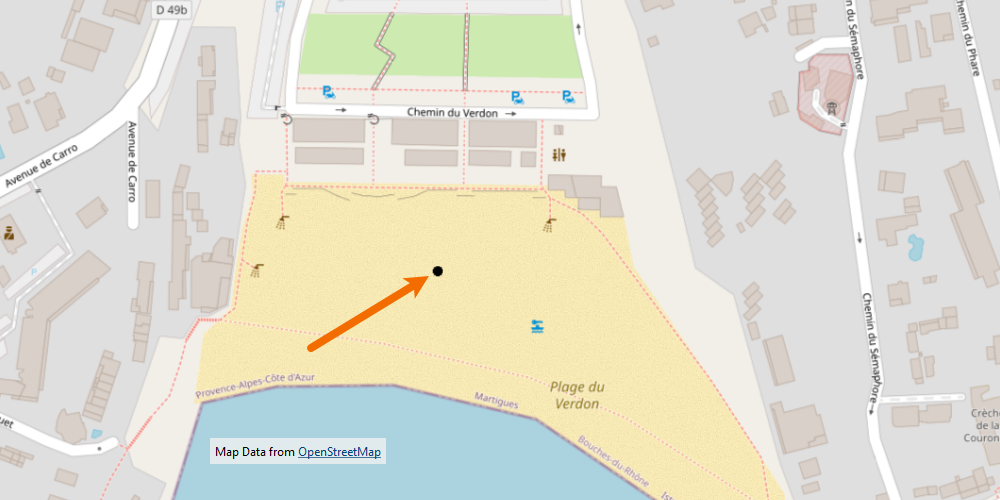
| Intersection | Plage du Verdon, Martigues, France, Europe | 43.33262172 | 5.04985106 |
The codes and FME clues would be exact, because they were provided as actual coordinates. The Images and Geography clues might be slightly different, because you had to estimate them from a photograph or map.
Here's the FME workspace I created to find the intersection point. I threw in a LineCombiner just to visualize the line extension a little better.
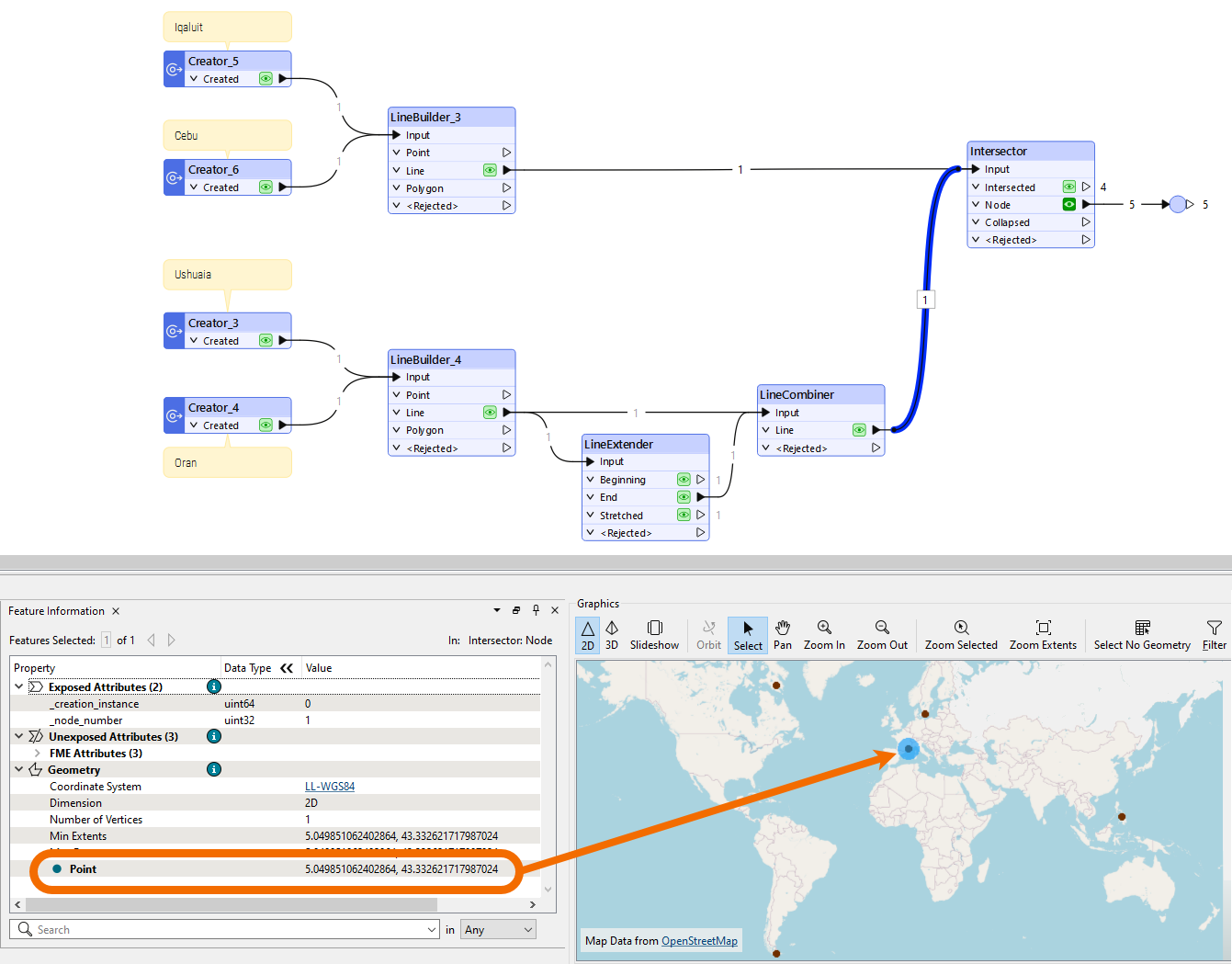
And here's a map of the intersection point where the treasure was buried:
Unspoken Clues
Almost everything in the game had some meaning towards the contest as a whole. Here are some of these clues:
- Greenbeard the lizard lived on a French island and occasionally mixed French into his speech.
- It is therefore logical to suggest that Greenbeard buried his treasure in France, or one of its territories.
- All of the code puzzles returned an animal. Except for giraffes (sorry, I ran out of time to change it) all of these animals are native to southern France or the general area.
- These were clues that the treasure was in the southern France area.
- Traditionally, an explorer buries treasure close to shore, in a place where it is easy to dig.
- It is therefore logical to suggest that the treasure would be buried on a beach, not an urban area.