Hi
I have too many problems to solve this question. So any help would be appreciated.
I have a point (centerpoint ) defined in geolat and geolong coordinates. No problem for me to have this point in decimal degrees or in radian coordinates.
I have also a radius (23 NM ). I found a way to output this radius in 2 coordinates of meters (primary axis x is East -West and secondary axis is North -South ) because i draw this circle with a ellipsoidal représentation. It's an airspace and when i project this airspace with FME i have to obtain an ellipse.
Formulae here : https://knowledge.safe.com/articles/725/calculating-accurate-length-in-meters-for-lat-long.html
( the excel file do the job )
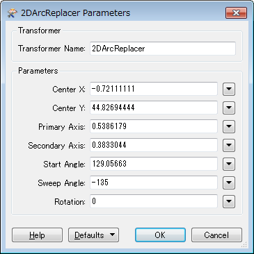
In input i gave the latitude of the centerpoint in décimal degrees. For my example ( 44°49'37"N - 0°43'16"W) and in decimal degrees (44,82694444 ; -0,72111111). I obtained 2 values with the Excel file.
For latitude : 0,0089986 degrees per 1000 m
For longitude : 0,0126448 degrees per 1000 m
I multiplied these values per 42,596 ( the value of 23 NM in km) and i obtained :
For longitude : 0,5386179 ( x axis)
For latitude : 0,3833044 ( y axis)
These 2 last values are for the primary axis (x) and the secondary axis (y) of the final arcbycenterpoint.
This is for the first step. ...
In a second step i have to calculate the beginning and the ending of the arc. The beginning is obtained with an angle measured from the center to the direction of the starting point ( fictious point). Same way for the ending angle. No problem to obtain the startangle and the endangle and to measured them with the origin of the measures on the axis East-West with positive value in counterclockwise.
I obtained :
startangle : 129,05663
endangle : - 6,278174
The sweepAngle ( endangle - Startangle ) gives me -135.
All is nice. So i want now to draw this arc with FME. I saw a function in the FME objects api - Fmearc () and i would like to know how to set my parameters in a Python Caller transformer ( primary radius, secondary radius, center point , startangle, sweepAngle ) and if i'm on the correct way to do this job.
In the workbench shall i use some reprojector transformers before going in the Python caller. Before this transformer my coordinates are LL84 ( my famous center) and i have all the coordinates of the arcbycenterpoint in meters - ground unit . Am i on the true way ?
I have to obtain a structure like this one
In output i want obtained a gml description with the geometryExtractor
Any help in Pyhon and with reprojector would be nice
And if it exists an other way to obtain my arc. .....
Thanks a lot


