Hi everyone,
I'm in the process of creating a dataset that shows the painted lines for parking spaces in a parking lot.
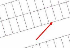
I've been using Bounds Splitter and Geometry Coercer to generate a grid of parking spaces along two rows of parking. However, I'd like the individual parking spaces to reflect the actual painted lines on the pavement. That is, instead of having a closed rectangle correspond to a parking space, I'd like to create a polyline dataset where only the three sides of the rectangle that correspond to the actual location of the paint on the pavement appear.
For example, I'm interested in removing the portion of the line that is touching the red arrow in the attached screenshot. Any ideas how to remove this portion of the line?
Thanks!
Jenna


