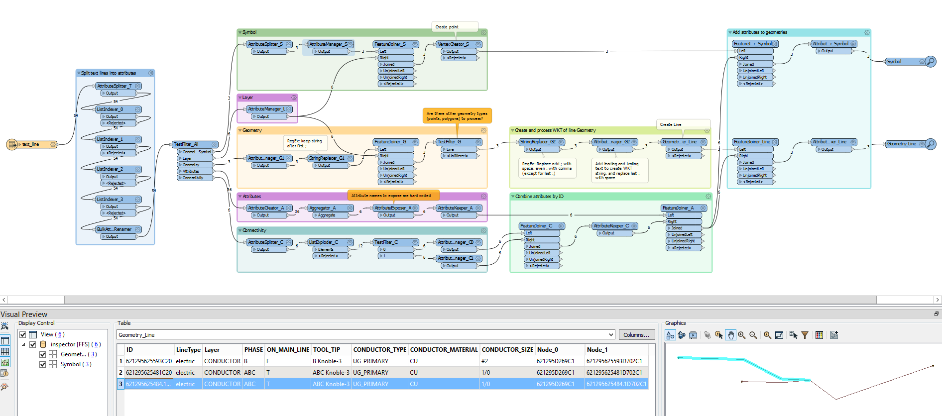
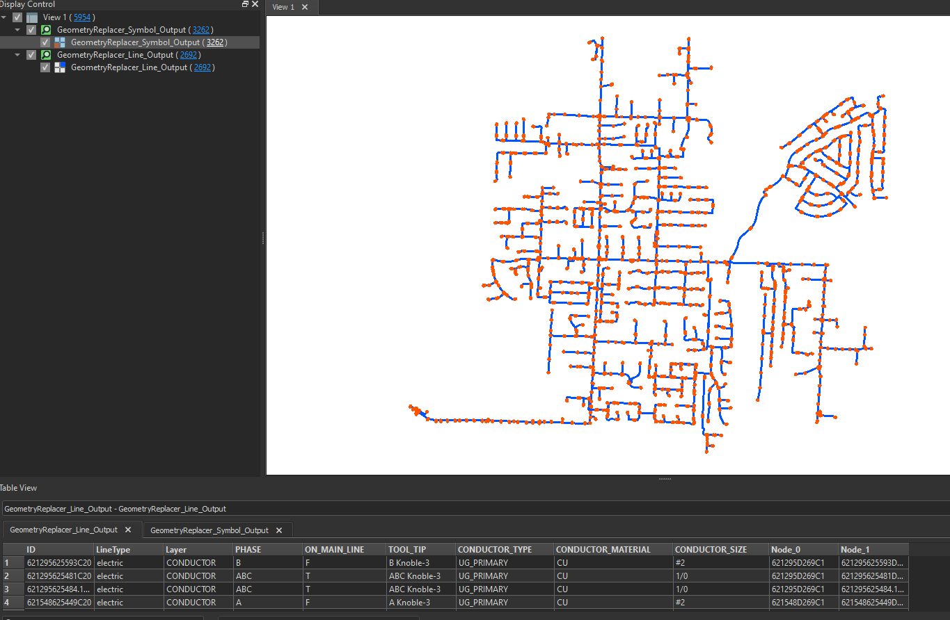
I received a sample data file from a client who wanted me to convert all their files from CGI's OMS .gis extension or called the M3i format, data is for Electric utility.
Though you can open the file in Notepad++, I tried to read it as well using Json Reader to be able to extract the attributes and geometry, but it seems it's hard to interpret the data structure from inside, to be able to parse it..
I also found this Safe webinar slides (here) talking about this format, and it looks like t's supported FME format though
here's a snippet of how this file looks like:
GIS M3I standard data, version 1
621295625593D702{GEOMETRY{SYMBOL{default;361368.971591387;194906.787360248;1;178
621295625593D702{CONNECTIVITY{NODE{621295625593D702C1;621295625593D702C2
621295625593D702{ATTRIBUTE{EQUIP_TYPE{ELBOW
621295625593D702{ATTRIBUTE{STATUS{C
621295625593D702{ATTRIBUTE{PHASE{B
621295625593D702{ATTRIBUTE{ON_MAIN_LINE{T
621295625593D702{ATTRIBUTE{DISPLAY_TEXT{\z3025J to 2433JB
621295625593D702{ATTRIBUTE{TOOL_TIP{3025J to 2433JB
621295625593D702{GEOMETRY{LAYER{EQUIPMENT
621295625593C20{GEOMETRY{LINE{electric;361372.714;194906.862;361371.244;194906.722;361368.971591387;194906.787360248
621295625593C20{CONNECTIVITY{NODE{621295D269C1;621295625593D702C1
621295625593C20{ATTRIBUTE{CONDUCTOR_TYPE{UG_PRIMARY
621295625593C20{ATTRIBUTE{CONDUCTOR_MATERIAL{CU
621295625593C20{ATTRIBUTE{CONDUCTOR_SIZE{#2
621295625593C20{ATTRIBUTE{PHASE{B
621295625593C20{ATTRIBUTE{ON_MAIN_LINE{F
621295625593C20{ATTRIBUTE{TOOL_TIP{B Knoble-3
621295625593C20{GEOMETRY{LAYER{CONDUCTOR
621295625481D702{GEOMETRY{SYMBOL{default;361379.541623473;194907.660007895;1;19
621295625481D702{CONNECTIVITY{NODE{621295625481D702C1;621295625481D702C2
621295625481D702{ATTRIBUTE{EQUIP_TYPE{ELBOW
621295625481D702{ATTRIBUTE{STATUS{C
621295625481D702{ATTRIBUTE{PHASE{ABC
621295625481D702{ATTRIBUTE{ON_MAIN_LINE{T
621295625481D702{ATTRIBUTE{DISPLAY_TEXT{\z3025J to 3725J
621295625481D702{ATTRIBUTE{TOOL_TIP{3025J to 3725J
621295625481D702{GEOMETRY{LAYER{EQUIPMENT
621295625481C20{GEOMETRY{LINE{electric;361372.714;194906.862;361374.167;194905.786;361379.541623473;194907.660007895
621295625481C20{CONNECTIVITY{NODE{621295D269C1;621295625481D702C1
621295625481C20{ATTRIBUTE{CONDUCTOR_TYPE{UG_PRIMARY
621295625481C20{ATTRIBUTE{CONDUCTOR_MATERIAL{CU
621295625481C20{ATTRIBUTE{CONDUCTOR_SIZE{1/0
621295625481C20{ATTRIBUTE{PHASE{ABC
621295625481C20{ATTRIBUTE{ON_MAIN_LINE{T
621295625481C20{ATTRIBUTE{TOOL_TIP{ABC Knoble-3
621295625481C20{GEOMETRY{LAYER{CONDUCTOR
621295625484.1D702{GEOMETRY{SYMBOL{default;361365.478948946;194908.104856725;1;178
621295625484.1D702{CONNECTIVITY{NODE{621295625484.1D702C1;621295625484.1D702C2
621295625484.1D702{ATTRIBUTE{EQUIP_TYPE{ELBOW
621295625484.1D702{ATTRIBUTE{STATUS{C
621295625484.1D702{ATTRIBUTE{PHASE{ABC
621295625484.1D702{ATTRIBUTE{ON_MAIN_LINE{T
621295625484.1D702{ATTRIBUTE{DISPLAY_TEXT{\z3025J to 2629P
621295625484.1D702{ATTRIBUTE{TOOL_TIP{3025J to 2629P
621295625484.1D702{GEOMETRY{LAYER{EQUIPMENT
621295625484.1C20{GEOMETRY{LINE{electric;361372.714;194906.862;361371.142;194906.931;361369.076;194908.004;361366.187;194908.085;361365.478948946;194908.104856725
621295625484.1C20{CONNECTIVITY{NODE{621295D269C1;621295625484.1D702C1
621295625484.1C20{ATTRIBUTE{CONDUCTOR_TYPE{UG_PRIMARY
621295625484.1C20{ATTRIBUTE{CONDUCTOR_MATERIAL{CU
621295625484.1C20{ATTRIBUTE{CONDUCTOR_SIZE{1/0
621295625484.1C20{ATTRIBUTE{PHASE{ABC
621295625484.1C20{ATTRIBUTE{ON_MAIN_LINE{T
621295625484.1C20{ATTRIBUTE{TOOL_TIP{ABC Knoble-3
621295625484.1C20{GEOMETRY{LAYER{CONDUCTOR
Any idea?


