Hi FME'ers,
This week's challenger was software developer Paul Nalos, who heads up the database team at Safe. Paul must have been working here for 10 years or more, but does he have the same knowledge of Desktop functionality - or the same luck at answering bizarre questions - as you do?!
First let's see the correct answers...
Answers1) Which of these is NOT an option on the Tools menu in Workbench?
- Browse FME Hub
- Browse Coordinate Systems
- Browse Readers and Writers
- Browse Web Connections
- Browse Geographic Transformations
This is simple question because you can just look in Workbench. Paul didn't have that luxury. He would know about the coordinate systems and geographic transformations because that's part of his team's responsibilities. I think for him it came down to either the Hub or Web Connections. A 50:50 call, and he picked the wrong one:
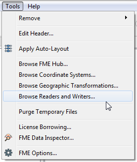
So, the answer is Browse Web Connections. I guess it's not really necessary; you can just use Tools > FME Options > Web Connections to see those instead.
Paul's Answer: Browse FME Hub (Incorrect)
2) Following on from a Twitter thread last week, how are the cities of St. Louis (US), Skopje (Macedonia), Mosul (Iraq), and Stavanger (Norway) related to FME?
- When their names are converted to FME Binary with the TextEncoder transformer, the results are all prime numbers
- They are all brand new events in the upcoming FME World Tour
- They are all home to breeding populations of Foster's Marisora Eft, literally an FME Lizard
- Their airport codes all match an FME format short name
- They are all locations where Safe is legally prohibited from selling FME
This was one of those online conversations that lead you down a rabbit hole (i.e. you wander far from the original topic and spend too much time on it)!
- Dale Lutz did an interview on the MapScaping podcast where he mentioned airports using Shapefile as a transfer format.
- FME user Carlos asked on Twitter which airport that would be.
- I suggested it might be airport SHP, if only there was one.
- Dmitri followed up with a dataset showing all airports whose code shared a format name with FME
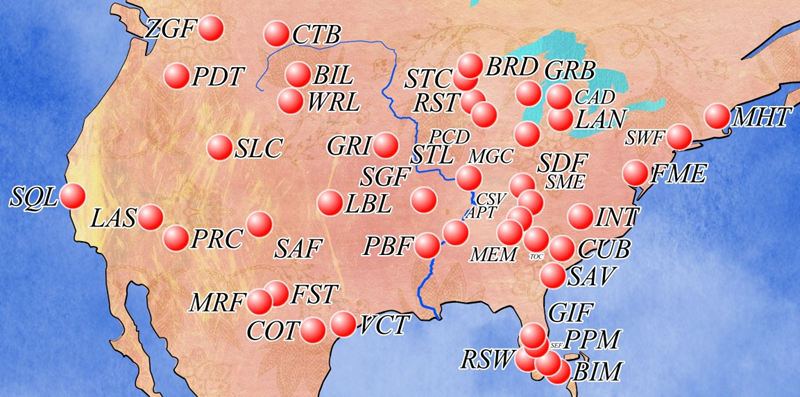
So that's the answer. These are all cities whose airport code matches a format shortname in FME. In this case the airport codes are STL (St. Louis/Standard Triangle Language), SKP (Skopje/Trimble SketchUp), OSM (Mosul/OpenStreetMap), and SVG (Stavanger/Scalable Vector Graphics).
Some users had even flown a couple of "FME Format routes"...
They are not - as Paul wondered - brand new events on the FME World Tour. And nobody picked the FME Lizard answer, which took me ages to come up with. For your information, an eft is the juvenile state of a newt, but as far as I know there is no Foster's Marisora Eft.
Paul's Answer: Brand New Events in the FME World Tour (Incorrect)
3) The Enable/Disable Dark Mode functionality in FME Server has what icons on the menu?
- A light switch in the up position (Enabled) or down position (Disabled)
- A sun (Enabled) or moon (Disabled)
- A light bulb either on (Enabled) or off (Disabled)
- A checkerboard that flips the light and dark squares (for Enabled and Disabled)
- A face wearing sunglasses (Enabled) and a face without (Disabled)
The two icons are a sun and moon. I think that's a nice, global representation. When dark mode is enabled the icon is a sun, to signify that clicking the icon turns you back to light mode. When light mode is enabled the icon is a moon, to signify that clicking the icon turns on dark mode.
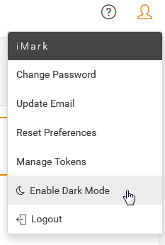
I know not everyone has access to FME Server, and I was surprised to find there is no screenshot in the documentation either. If you wanted to be really sure you could have dived into one of the webinars (especially the launch webinar) but most people got this correct anyway, including Paul.
Paul's Answer: A sun or moon (Correct)
4) At a previous FME user conference, the FMEopardy quiz included questions on converting format names in what language?
- French
- Latin
- Swedish
- Esperanto
- Klingon
This, it turns out, was over ten years ago now, at the user conference in Whistler, 2009. It didn't turn up many Google hits, but you could find an article on our blog where I explained how the competition was held.
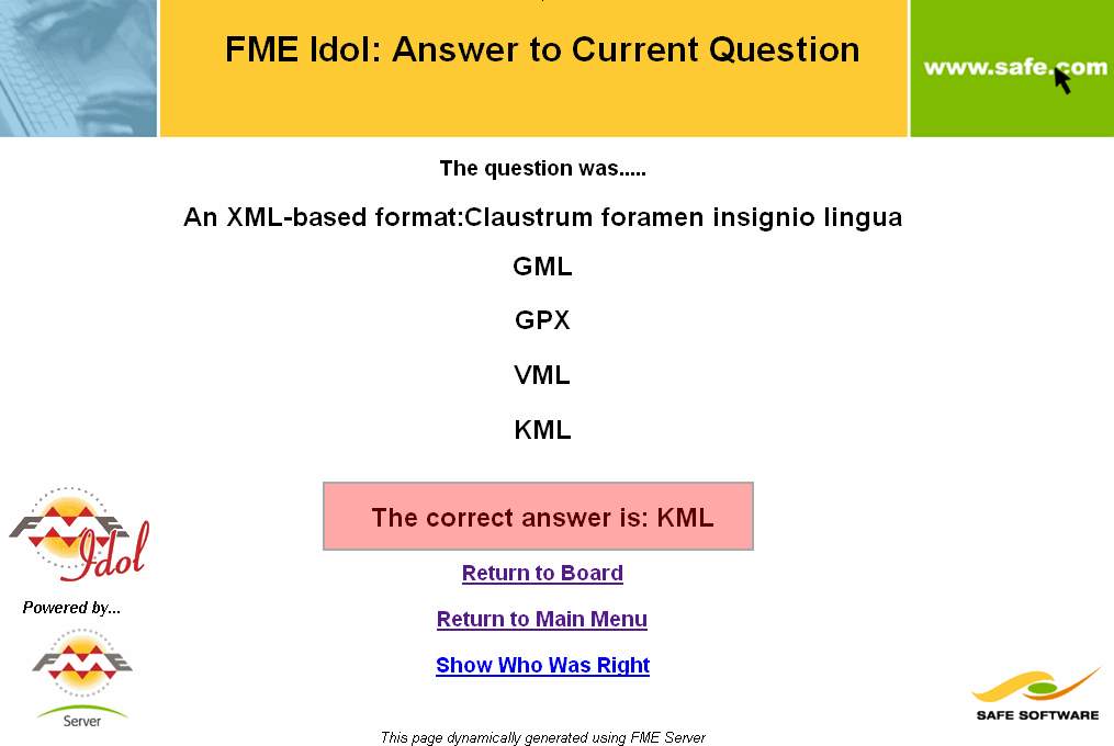
So the answer was Latin. Above it's meant to represent "Keyhole Markup Language (KML)". I gave - and continue to give - no guarantees about my Latin grammar!
Paul's Answer: Swedish (Incorrect)
5) Which one of these is NOT a valid styler transformer?
- KMLStyler
- DGNStyler
- GeodatabaseStyler
- MapboxStyler
- PowerPointStyler
A styler transformer sets the symbology (visual appearance) of features as they are stored in the dataset. It is usually related to a specific format (the AppearanceStyler is "the exception that proves the rule") and mostly for formats that have distinct geometry types or styling requirements.
For example, the DGNStyler can set cells (point feature symbols) by selecting the symbol from a "cell library", which is something you wouldn't want in a generic transformer like the FeatureColorSetter.
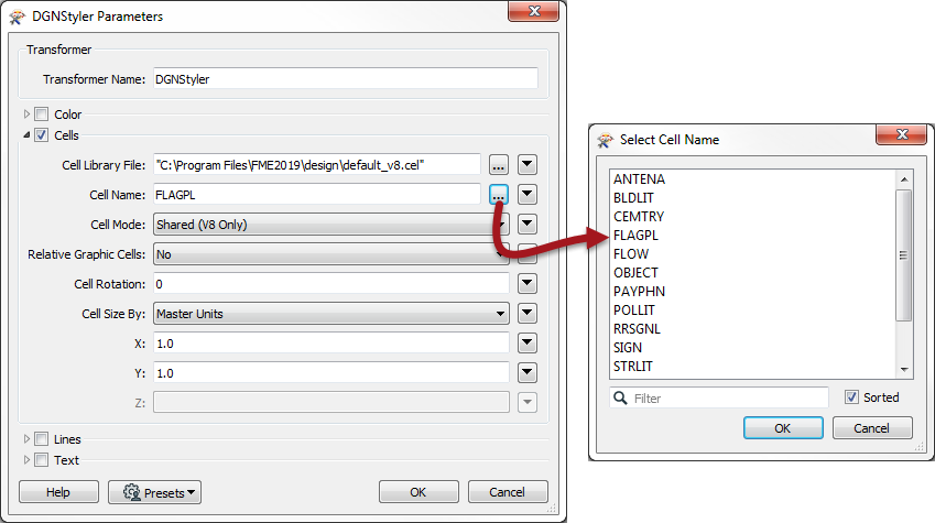
But even when proprietary software allows symbology, that symbology often isn't stored in the related format. For example, Geodatabase stores data only, not symbology, so there's no need for a GeodatabaseStyler transformer.
As Paul's team is responsible for Geodatabase, you would expect him to know this question, and he did.
Paul's Answer: GeodatabaseStyler (Correct)
6) One of our teams at Safe Software is called the PVR team. What does PVR stand for?
- Point Cloud, Vector, Raster
- Performance Virtualization and Responsiveness
- Processing, Visualization and Readers/Writers
- Python, VB .NET, R
- Polygon and V-Space Reprojection
This is usually the "IMPOSSIBLE" question, and you are unlikely to know what our teams are called inside Safe (plus it's not something you should need to know). On the other hand, it was hard to make up realistic acronyms and the correct answer was the most obvious.
The Point Cloud, Vector, Raster (PVR) team cover a lot of ground in FME development and, as I already mentioned, Paul runs the Database team, now called the CMD team (CAD, Modelling, Database). We also have a geometry team (they're the ones I'd want to join if I were a developer), Workbench team, Python team, Infrastructure/Integrations team, and several teams of Server developers too.
Anyway, Paul, needless to say, knew this one.
Paul's Answer: Point Cloud, Vector, Raster (Correct)
ScoresWere you keeping count there? Paul got 3 correct; a decent score, but beatable.
Let's see, but first, the general info:
- Quiz Week: 13 (Jan 27/2020)
- Number of Entries: 28
- Best Score: 6
- Worst Score: 2
- Average Score: 4.21
- Easiest Question: 1 (28)
- Hardest Question: 4 (4)
So slightly tougher than last week, but still an average of 4.21 is fairly high.
The hardest question was the User Conference language one, but that's not too much of a surprise. Anyway, the final score:
- Beat Paul: 22
- Equalled Paul: 4
- Were Beaten by Paul: 2
Sorry Paul, you were well and truly thrashed by our users there, a good comeback from the users after a couple of defeats in a row. If you're keeping track, the current score since we started pitching Safers vs Users is:
- Users 3 Safers 3
A nice equal score there. As last week, here's the list of individual user records:
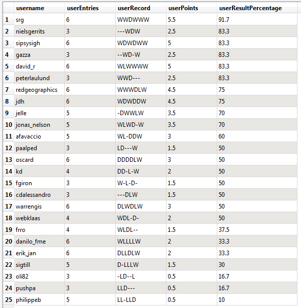
W means you won that week (1 point), D means you drew/tied (0.5 points) and L means you lost (nil points). A dash (-) means you missed that week's quiz.
@srg still heads up the league and @david_r now has a win streak of 4 in a row. @philippeb breaks his losing streak and draw-specialist @oscard finally picked up a win. @warrengis not just got a win but also a perfect 6/6 score.


