
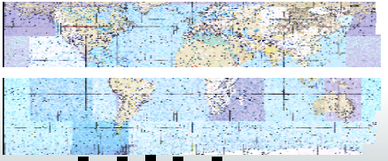
I have been attempting to export a mosaic into CADRG (.GN), on a set of maps that I stitched together and created one single global GeoTiff. Each time I run the CADRG writer the export completes but automatically projects in Polar Sterographic projection and has had a blank band through the center of the chart. Ideally I would like this export to be in Geo Lat Long WGS84. Does anyone know hoe to solve these issues?

Question
CADRG Writer
This post is closed to further activity.
It may be an old question, an answered question, an implemented idea, or a notification-only post.
Please check post dates before relying on any information in a question or answer.
For follow-up or related questions, please post a new question or idea.
If there is a genuine update to be made, please contact us and request that the post is reopened.
")

Login to the community
No account yet? Create an account
An FME Account is required to contribute
LoginEnter your E-mail address. We'll send you an e-mail with instructions to reset your password.