Trying to generate an Esri Shapefile Polygon output of areas with data merged from multiple datasets to the Area dataset.
The addition of Location Names (at least one per area) seems to be throwing up an issue.
After doing the steps below the Transformer Views and Shapefile Symbology changes and goes a bit weird, and I’m not exactly sure how to sort it.
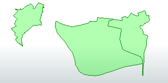
Below polygon symbology is one area, but there are probably 30% of 1000 Polygons that have similar symbology issues.
Any help would be greatly appreciated - Many thanks.
Step One:
Feature Merger Requestor: Area Dataset Supplier: Location Name Dataset Merge on AreaID
Generate List: List Name: _list Add to List: Selected Attributes Selected Attributes: Location_Name
Feature Merger: Merged Output
Step Two:
List Exploder List Attribute: _list Accumulation Mode: Merge List Attributes Conflict Resolution: Use List Attribute Values
List Exploder: Elements Output
Step Three:
Aggregator to update the Location_Name to have multiple names, where applicable, e.g. City A, Town B, Village B added to each AreaID.
Step Four:
Attribute Manager to tidy the dataset for output, get rid of redundant fields.
Step Five:
Output to ESRI Shapefile load in to ArcGIS Pro Even with Symbology set to Single Symbol:
Single Symbol
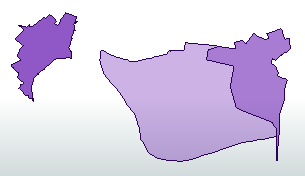
Or Unique Values based on AreaID:
Unique Values
Best answer by bwn
That is somewhat difficult to diagnose without seeing sample output in Data Inspector, or not seeing the workspace Transformers with Summary Annotation
Eg. What are the Feature(s) that are output by Aggregator on the right if send them to an Inspector? How is the workspace designed showing Transformer Summary Annotation? (Ctrl-Shift-K is the shortcut to show Summary Annotation for a Transformer)
Otherwise a guess would be that there are 2 or more polygons on top of each other. This will sometimes have a “cancelling” effect on the fill symbology in ArcGIS. Aggregator will not just concantenate the fields, but will also create Aggregated geometries, and it is likely that this is creating multipolygons comprising duplicate polygons where there were many Locations joining to 1 Area.
A further clue to this is the symbology in Data Inspector from the ListExploder. The “lighter” and “darker” shading is indicating there are multiple polygons output for the one area. In Aggregator default settings, this is going to lead to multipolygons with either an odd number of identical polygons making up the mutipolygon, or an even number of identical polygons. ArcGIS can “cancel” fill symbology for even numbers of identical polygons in one multipolygon, although it may likely be that there are bigger problems in that there are also undesirable multipolygons with odd numbers of identical polygons that “appear” to be correct in ArcGIS from the fill shading, but are not and will have Eg. the wrong calculated polygon area being say 3 x more reported area for an Area polygon output from ListExploder 3 times and then Aggregated into a multi comprising 3 x ListExploder polygons.
Instead of doing a ListExploder->Aggregator: Consider just using ListConcantenator on the output of FeatureMerger to create the delimited single value of Location Names.
This post is closed to further activity.
It may be an old question, an answered question, an implemented idea, or a notification-only post.
Please check post dates before relying on any information in a question or answer.
For follow-up or related questions, please post a new question or idea.
If there is a genuine update to be made, please contact us and request that the post is reopened.
That is somewhat difficult to diagnose without seeing sample output in Data Inspector, or not seeing the workspace Transformers with Summary Annotation
Eg. What are the Feature(s) that are output by Aggregator on the right if send them to an Inspector? How is the workspace designed showing Transformer Summary Annotation? (Ctrl-Shift-K is the shortcut to show Summary Annotation for a Transformer)
Otherwise a guess would be that there are 2 or more polygons on top of each other. This will sometimes have a “cancelling” effect on the fill symbology in ArcGIS. Aggregator will not just concantenate the fields, but will also create Aggregated geometries, and it is likely that this is creating multipolygons comprising duplicate polygons where there were many Locations joining to 1 Area.
A further clue to this is the symbology in Data Inspector from the ListExploder. The “lighter” and “darker” shading is indicating there are multiple polygons output for the one area. In Aggregator default settings, this is going to lead to multipolygons with either an odd number of identical polygons making up the mutipolygon, or an even number of identical polygons. ArcGIS can “cancel” fill symbology for even numbers of identical polygons in one multipolygon, although it may likely be that there are bigger problems in that there are also undesirable multipolygons with odd numbers of identical polygons that “appear” to be correct in ArcGIS from the fill shading, but are not and will have Eg. the wrong calculated polygon area being say 3 x more reported area for an Area polygon output from ListExploder 3 times and then Aggregated into a multi comprising 3 x ListExploder polygons.
Instead of doing a ListExploder->Aggregator: Consider just using ListConcantenator on the output of FeatureMerger to create the delimited single value of Location Names.
ListConcantenator has sorted it! as below - sorry I couldn’t give more details, but even with that limited detail you’ve helped massively