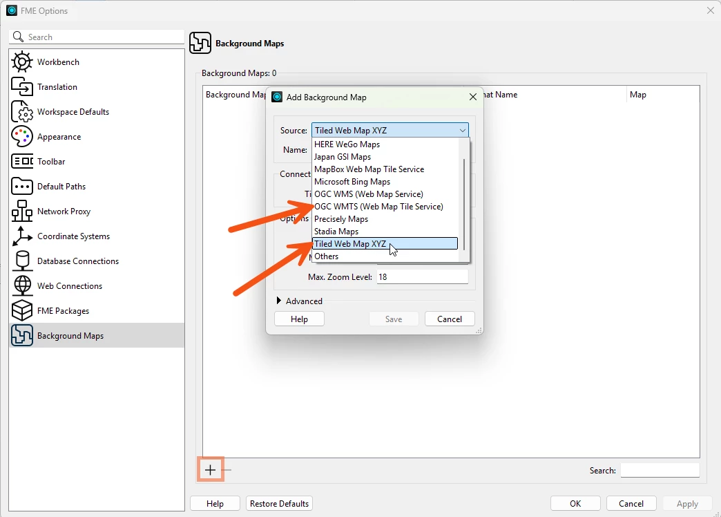
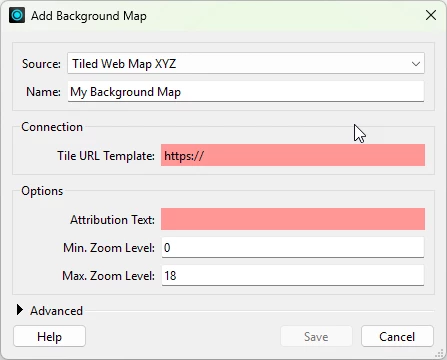
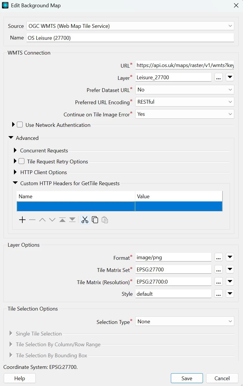
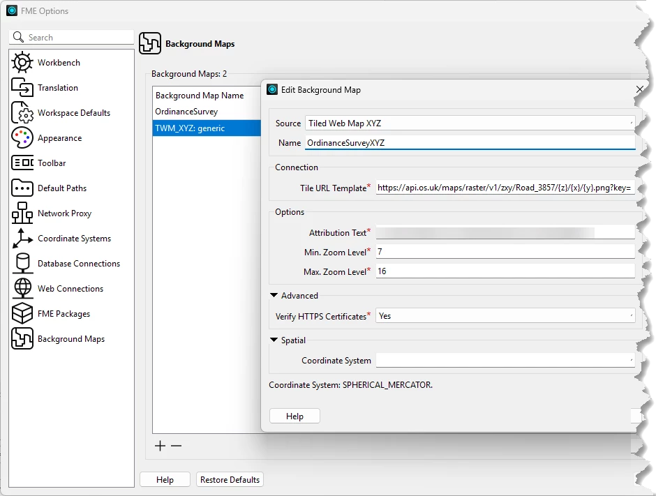
Has anyone in the UK who is using the Ordnance Survey Maps API managed to get them added into FME for use as a background map. I have tried and get nothing to display….
Hi @ingalla! Did you happen to run into any particular issues trying to use the basemap? I haven't tested this myself but looking into their OS Maps API documentation, you should be able to use this service.
Looks like OS has OGS WMTS and ZXY versions available, which in FME, may fall under OGC WMS (Web Tile Service) and Tiled Web Map XYZ.
FME Options>Background maps> “+”
Depending on the API version, the configuration may be a little different.
Let me know how it goes though! Happy to figure this out with you and the community
I’ve followed these steps and unfortunately it just says “unable to display background map...”. My data is in 27700
Hi @ingalla! Did you happen to run into any particular issues trying to use the basemap? I haven't tested this myself but looking into their OS Maps API documentation, you should be able to use this service.
Looks like OS has OGS WMTS and ZXY versions available, which in FME, may fall under OGC WMS (Web Tile Service) and Tiled Web Map XYZ.
FME Options>Background maps> “+”
Depending on the API version, the configuration may be a little different.
Let me know how it goes though! Happy to figure this out with you and the community
Hi @hannahwh05. Would you mind sharing your setup?
You might also want to test out calling the API outside of FME, like Postman or CURL. Customers tend to find this particularly useful when testing and isolating potential issues!
As a friendly reminder, the API key might be visible, so you’d want to censor that!
I have also had problems adding the OS Maps Web Service as a background. No problems testing the API with QGIS, ArcGIS or AGOL using the below parameters.
Error is
FME Objects Worker [27672] > Failed to read features from dataset 'https://api.os.uk/maps/raster/v1/wmts?key=xxxxxxxxxxxxxxxxxxxxxxxxxx' using the 'WMTS' reader
Also tried the XYZ and got similar message
FME Objects Worker [37664] > Failed to read features using the 'TWM_XYZ' reader
I have a similar issue with the LINZ NZ Basemaps service and get the same error (URL works with QGIS, ArcGIS or AGOL)
You can grab this from OS Data Hub under APIs > API Projects > [Your Project]
Attribution Text: Available on the OS website
Cross-reference the OS Maps API doc Layers and Styles to confirm these details match what you need.
Configuring the Base Map in FME Options:
Tile URL Template: The URL from above
Min Zoom Level: 7
Max Zoom Level: 16
Testing: I tested with a point at coordinates (-421856, 6642103) in EPSG:3857, and it displayed correctly once everything was configured.
One gotcha I ran into: Initially I was testing with a point outside of Great Britain, which just showed an empty map. Is that what you folks were seeing, or is something else going on? Happy to help troubleshoot further if you're still stuck!