Solved

ESRI Pro Annotation has different location when viewed in FME

  • January 21, 2025
  • 2 replies
  • 76 views

juliarozema
Contributor
Forum|alt.badge.img+9

Ultimate Goal: to use FME to test if there are ESRI annotations that fall on top of each other.  

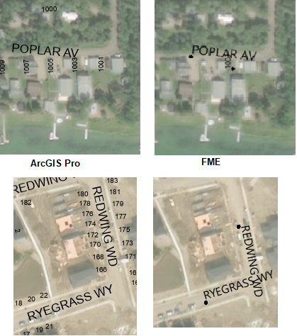
Issue being experienced: When the ESRI annotation is displayed in FME Inspector, the annotation has been shifted.  My theory is the “shift” is something to do with the annotation is left justified in ArcGIS Pro and its placement of the annotation is based on a point in the bottom left corner.  In FME the annotation point seems to be placed along the bottom centre.  

Question: Is there a way to have FME place the ESRI Annotation based on the same placement point?
OR
How can we shift the annotation when being viewed in FME so that it is placed half of the width of the annotations to the left along the annotation axes?  


ArcGIS Pro: 3.2.3
ArcGIS SDE: SQL 2022
FME Form: FME(R) 2024.1.3.0 (20240927 - Build 24627 - WIN64)
FME Annotation Reader Format: Esri Geodatabase (ArcSDE Geodb)


See attached imagery for example of annotation shift. 


Best answer by debbiatsafe

Hello ​@juliarozema 

You can try reading the ArcSDE annotations using a SQL Server Spatial reader instead of the ArcSDE Geodatabase reader. This creates polygon features, representing bounding boxes of each annotation features but does appear to take into account for things like vertical and horizontal alignment.

The polygons in the attached screenshot represents what is output from the SQL Server Spatial reader when reading a Pro annotation. The bounding box contains the highlighted annotation feature, which has a center horizontal alignment and top vertical alignment set.


This post is closed to further activity.
It may be an old question, an answered question, an implemented idea, or a notification-only post.
Please check post dates before relying on any information in a question or answer.
For follow-up or related questions, please post a new question or idea.
If there is a genuine update to be made, please contact us and request that the post is reopened.

2 replies

debbiatsafe
Safer
Forum|alt.badge.img+21
  • Safer
  • Best Answer
  • January 24, 2025

Hello ​@juliarozema 

You can try reading the ArcSDE annotations using a SQL Server Spatial reader instead of the ArcSDE Geodatabase reader. This creates polygon features, representing bounding boxes of each annotation features but does appear to take into account for things like vertical and horizontal alignment.

The polygons in the attached screenshot represents what is output from the SQL Server Spatial reader when reading a Pro annotation. The bounding box contains the highlighted annotation feature, which has a center horizontal alignment and top vertical alignment set.


juliarozema
Contributor
Forum|alt.badge.img+9
  • Author
  • Contributor
  • January 29, 2025

Thank you ​@debbiatsafe.
This looks to be quite helpful.  I need to do a bit more testing, but I think this is what I need.

Thank you for your time and help.