Solved

Error Writing Multipart Geometries to ArcGIS Online with New Esri ArcGIS Feature Service Writer

  • September 25, 2025
  • 7 replies
  • 264 views

paul_m
Contributor
Forum|alt.badge.img+18

We have multiple workspaces that write to ArcGIS Online with multipart geometries. The old ARCGISONLINEFEATURES writer works and correctly writes the geometries. The new (2025) Esri ArcGIS Feature Service Writer returns an error rejecting the features and the following warning:
ArcGISFeatureServiceWriter: INSERT error for a feature in Project Stats by State. The error code from the server was '1000' and the message was 'Adding/updating geometries that result in SQL GeometryCollections is currently not supported (SQL Server performance).'
 

Using a Deaggregator seems to fix this in most cases. However, we want to retain the multipart geometries. In other cases, I see a similar warning and the following error after using a Deaggregator:
ArcGISFeatureServiceWriter: INSERT error for a feature in Terracon Offices Closest Areas. The error code from the server was '1000' and the message was 'Data is Null. This method or property cannot be called on Null values.'
 

I’ve tried a NullAttributeMapper and only writing a single column that I know has 0 NULLs and see the same error and warning. Has anyone ran into these issues with the new writer? If so, have you found a workaround?

Best answer by crystalwang

Hi FME Community,

For anyone experiencing issues with data being written to the wrong location, this behavior seems to be related to coordinate system differences between reference-registered data and the Feature Service’s spatial reference.

The Target WKID parameter on the writer determines the output coordinate system. The writer should automatically respect the existing Feature Service’s spatial reference during inserts and updates, but it is not doing so at this time.

To ensure your data is placed correctly, please check the feature service metadata (e.g., /FeatureServer?f=json) to identify the coordinate system used by the service, and enter that WKID value in the writer’s Target WKID parameter.

Our team is aware of this issue and is working on improving this behavior (tracked internally as FMEENGINE-88607). The expected behavior is that the Feature Service Writer automatically detects and applies the Feature Service’s spatial reference WKID from the service metadata when inserting to an existing Feature Service.

We apologize for the inconvenience, and thank you for your patience in the meantime!

7 replies

crystalwang
Safer
Forum|alt.badge.img+14
  • Safer
  • September 30, 2025

Hi ​@paul_m,


This sounds similar to an issue we’re tracking internally as FMEENGINE-88156. If you can please submit a ticket so that our Support team can look into this further, that would be great!

We’ll be able to better assist you with more information. When submitting your ticket, please provide the following (if available/possible):

  • Details about the environment used (e.g. platform and OS version, FME Form version, any other dependencies, etc.)
  • Please provide a sample of the source data used in your workspace
  • The workspace (or sample workspace) that you are encountering issues with. Please be sure to include any required data or custom transformers needed. If, possible please send this as a template (.fmwt).

In the meantime, could you try changing the following parameter in the writer and seeing if that fixes the errors?

  • Use True Curves > No

paul_m
Contributor
Forum|alt.badge.img+18
  • Author
  • Contributor
  • October 2, 2025

Hi ​@paul_m,


This sounds similar to an issue we’re tracking internally as FMEENGINE-88156. If you can please submit a ticket so that our Support team can look into this further, that would be great!

We’ll be able to better assist you with more information. When submitting your ticket, please provide the following (if available/possible):

  • Details about the environment used (e.g. platform and OS version, FME Form version, any other dependencies, etc.)
  • Please provide a sample of the source data used in your workspace
  • The workspace (or sample workspace) that you are encountering issues with. Please be sure to include any required data or custom transformers needed. If, possible please send this as a template (.fmwt).

In the meantime, could you try changing the following parameter in the writer and seeing if that fixes the errors?

  • Use True Curves > No

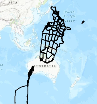
Thanks for all the info! I’ll submit a ticket. I did set True Curves to No, and the data wrote without errors, but the result is very wrong (see below). When writing the same exact data with the old ArcGIS Online writer, everything shows up in the right place with no errors.


rhatch
Participant
Forum|alt.badge.img
  • Participant
  • October 7, 2025

I’m having similar issues (data loads fine to AGOL content when using the old connector, but rotates and moves off the coast of Australia when using the new new ArcGISconnector. I’m assuming it’s a projection issue, but have had no luck fixing it. Were you able to solve this issue? Thanks!


paul_m
Contributor
Forum|alt.badge.img+18
  • Author
  • Contributor
  • October 8, 2025

I’m having similar issues (data loads fine to AGOL content when using the old connector, but rotates and moves off the coast of Australia when using the new new ArcGISconnector. I’m assuming it’s a projection issue, but have had no luck fixing it. Were you able to solve this issue? Thanks!

No workarounds yet, but I do have a ticket open with Safe Support regarding the issue.


markcoopersdc
Contributor
Forum|alt.badge.img+6

I have had the same issue and have had to revert to the old feature writer.

I have also raised a ticket with Safe


paul_m
Contributor
Forum|alt.badge.img+18
  • Author
  • Contributor
  • October 20, 2025

Quick update from communicating with Safe Support: As of now, the only workaround is using the older Esri ArcGIS Online writer. Safe’s development team is looking into the issue with the new writer.


crystalwang
Safer
Forum|alt.badge.img+14
  • Safer
  • Best Answer
  • November 12, 2025

Hi FME Community,

For anyone experiencing issues with data being written to the wrong location, this behavior seems to be related to coordinate system differences between reference-registered data and the Feature Service’s spatial reference.

The Target WKID parameter on the writer determines the output coordinate system. The writer should automatically respect the existing Feature Service’s spatial reference during inserts and updates, but it is not doing so at this time.

To ensure your data is placed correctly, please check the feature service metadata (e.g., /FeatureServer?f=json) to identify the coordinate system used by the service, and enter that WKID value in the writer’s Target WKID parameter.

Our team is aware of this issue and is working on improving this behavior (tracked internally as FMEENGINE-88607). The expected behavior is that the Feature Service Writer automatically detects and applies the Feature Service’s spatial reference WKID from the service metadata when inserting to an existing Feature Service.

We apologize for the inconvenience, and thank you for your patience in the meantime!