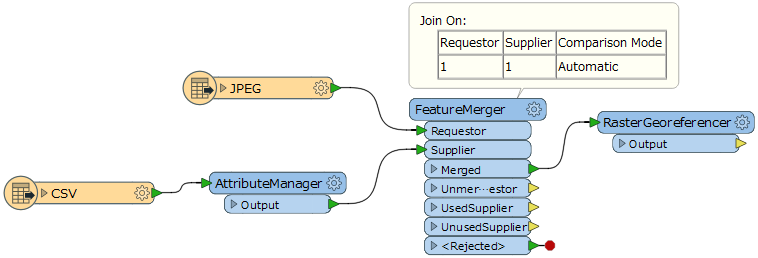
I have a JPG image and a CSV file with data that can be used to geo-reference it (attached).
I've built a Workspace to apply the geo-referencing data to the JPG. AttributeManager makes FactorY a negative number as I found I needed to do this when working out the process using ArcGIS. In the RasterGeoferenencer, I've selected the relevant fields from the CSV file as shown in the screenshot. OutX and OutY are the Ordnance Survey Eastings and Northings.
When I run the Workspace in FME 2017.0.1.1 (64-bit), I get the following error:
2017-06-08 15:39:10| 0.8| 0.0|ERROR |@GeoreferenceRaster: Failed to retrieve X Upper Left Coordinate parameter
I've tried setting the coordinate system on the JPG Reader and/or the CSV Reader, and setting OutX and OutY to x_coordinate and y_coordinate in the CSV Reader and then as real32. None of these make a difference.
Any ideas?


