Question

clipper result smaller than polygon

  • January 15, 2026
  • 1 reply
  • 25 views

koenvdw
Contributor
Forum|alt.badge.img+7

Hi 

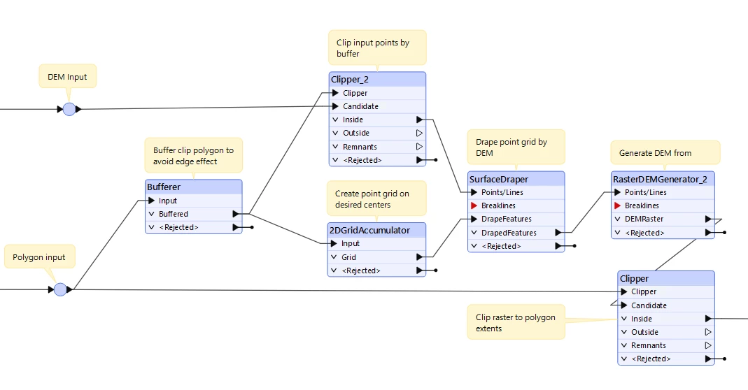
I’m clipping point clouds with a polygon (1km x 1km), the inside result goes through a rasterdemgenerator with a cell spacing of 0.5m and I write it away as a geotif. When I compare the result with the polygon I see that the geotif is 0.25m bigger than the polygon. 

I know it has something to do with how a pixel is considered. As a polygon or as point in the center or something, but it doesn’t make any sense to me as you can divide 1km perfectly by 0.5m… It should be 2000 pixels by 2000 pixels right? 

How do I solve this? 

I tried playing with the clipper settings. Like changing “determine cell location by” to bounds and some other things. I got a result that’s 0.25cm smaller, but never an exact fit. 

1 reply

daveatsafe
Safer
Forum|alt.badge.img+21
  • Safer
  • January 16, 2026

The RasterDEMGenerator centers the output raster pixels on the first point to reach the transformer, so the while the pixels will be the correct distance apart, the centers may not be aligned to 0.5, 1.0, etc.

You may also get edge effects from the clipped point cloud not extending all the way to the raster edge. I would recommend clipping the point cloud to the polygon buffered by 10m instead.

One way to get your output raster pixel aligned to the interval would be to use the 2DGridAccumulator to replace the clipping polygon with a 2d grid of points, then drape them on the point cloud. The 2DGridAccumulator allows you to specify both the point interval and seed coordinate, so you can ensure the point are perfectly aligned to the desired interval (0.0, 0.5, 1.0, etc.). After draping, send the points to the RasterDEMGenerator. Finally, clip the resulting raster by the polygon to get rid of the excess from the buffered boundary: