Solved

CAD file Geographical Coordinate System

  • October 31, 2025
  • 2 replies
  • 85 views

mlongstreet002
Contributor
Forum|alt.badge.img+1

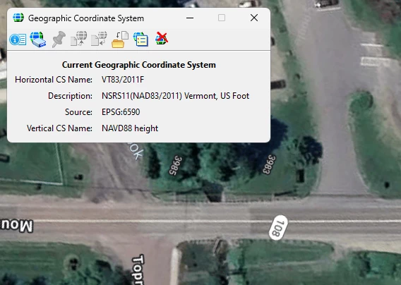
Is FME able to read the MicroStation DGN file geographical coordinate and use this information when creating esri geodatabase features?  I see several tutorials and methods that seem to suggest CAD data such as DGN (MicroStation Design Files) do not contain geographic Coordinate systems but is not totally true.  Design files do or can have coordinate systems, and most do when relative to Transportation Civil Engineering Design.


Best answer by crystalatsafe

Hi ​@mlongstreet002 

FME can read coordinate systems from DGN as long as the coordinate system has been set in the original DGN file.

After reading the DGN file, look at the record information (or feature information depending on the version you are using) on the right side of the workspace, the coordinate system information will be under geometry.


This post is closed to further activity.
It may be an old question, an answered question, an implemented idea, or a notification-only post.
Please check post dates before relying on any information in a question or answer.
For follow-up or related questions, please post a new question or idea.
If there is a genuine update to be made, please contact us and request that the post is reopened.

2 replies

crystalatsafe
Safer
Forum|alt.badge.img+26
  • Safer
  • Best Answer
  • November 3, 2025

Hi ​@mlongstreet002 

FME can read coordinate systems from DGN as long as the coordinate system has been set in the original DGN file.

After reading the DGN file, look at the record information (or feature information depending on the version you are using) on the right side of the workspace, the coordinate system information will be under geometry.


mlongstreet002
Contributor
Forum|alt.badge.img+1
  • Author
  • Contributor
  • November 4, 2025

OK thanks I will look for that Value.