Question

ArcGIS Server map service cache

  • August 23, 2018
  • 3 replies
  • 98 views

philippeb
Enthusiast
Forum|alt.badge.img+22

I have services into ArcGIS Server with the cache enabled.

I use it as my basemap into applications, it is super fast, cuz it's tiled.

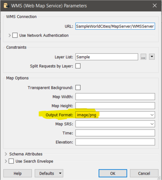
Can I view those tiles into FME?

When I try to read the service with Data Inspector, I only see the vectors, without the symbology! And it takes an eternity to read! The tiles are created from millions of vectors.

I'm using the usual link from ArcGIS Server : http://MyServer/arcgis/rest/services/MyBasemap/MapServer

Got an idea? Or it is impossible right now?

This is my closest scale.

This post is closed to further activity.
It may be an old question, an answered question, an implemented idea, or a notification-only post.
Please check post dates before relying on any information in a question or answer.
For follow-up or related questions, please post a new question or idea.
If there is a genuine update to be made, please contact us and request that the post is reopened.

3 replies

rahulsharma
Safer
Forum|alt.badge.img+10
  • Safer
  • 359 replies
  • October 24, 2018

Hi @philippeb, As per my understanding you should be able to use WMS format to read the data and it should bring the map as an image.


Format -- WMS(Web Map Service)

Dataset -- URL (from ArcGIS Server WebMap service)

Layer List -- <Pick your layer>

Parameter --> Map Options --> Output Format -- image/png (optional)


philippeb
Enthusiast
Forum|alt.badge.img+22
  • Author
  • Enthusiast
  • 329 replies
  • October 25, 2018

Hi @philippeb, As per my understanding you should be able to use WMS format to read the data and it should bring the map as an image.


Format -- WMS(Web Map Service)

Dataset -- URL (from ArcGIS Server WebMap service)

Layer List -- <Pick your layer>

Parameter --> Map Options --> Output Format -- image/png (optional)


Hi thanks for your answer!

Your method is working but the resolution is very bad! Layers are very pixelised. Do you think there would be a solution to upgrade that?


Second thing, the WMS can be read into FME only if the service isn't cached. I would have to recreate my basemap service without cache... is that normal?


rahulsharma
Safer
Forum|alt.badge.img+10
  • Safer
  • 359 replies
  • October 25, 2018

Hi thanks for your answer!

Your method is working but the resolution is very bad! Layers are very pixelised. Do you think there would be a solution to upgrade that?


Second thing, the WMS can be read into FME only if the service isn't cached. I would have to recreate my basemap service without cache... is that normal?


Hi Phillip,


There are definitely some restriction on the image quality and Tiling, but if you can access your add in another way as a PNG/JPEG (or any raster) it would be much easier to read with full quality.


It appears that the quality of the image on ArcGIS Server is as such, Using sample URL (seen below ) with HTTPCaller and JSON Fragmenter


http://sampleserver1.arcgisonline.com/ArcGIS/rest/services/Specialty/ESRI_StateCityHighway_USA/MapServer/export?bbox=-115.8,30.4,-85.5,50.5&bboxSR;=&layers;=&size;=800,600&imageSR;=102004&format;=gif&transparent;=false&dpi;=&f;=pjson


Note that the image is stored at http://sampleserver1b.arcgisonline.com/arcgisoutput/_ags_map7d1720b91b734fe3b2f8d5cec6fdeb13.gif


Quality of images generated on ArcGIS Server is not the highest quality.


The only other option get all details is to use ArcGIS Server FeatureService to read the actual vector data, but that doesn't seem to be a viable option.