
Hi everyone,
I need help, when i upload my shape file in fme which is in gaus kruger coordinate system
I want to change coordinate system into epsg 32634, and when i use coordinate system setter, it changes, but its not exactly how i need it to be
So i need to do something called transformation, and i need help with how to do that, if its posible to do transformation in FME?


Hi ​@simeon.simic In this case you will want to try the Reprojector transformer.


Does that work for you?


Hi ​@simeon.simic In this case you will want to try the Reprojector transformer.


Does that work for you?

To elaborate: the CoordinateSystemSetter is used to set the coordinate system in those cases where the data does not “know” it it but you do.


@crutledge Hi,
I already tried Reprojector transformer, it is incldued in my worskspace, but it doesnt work, i get the same result . The result i dont need, and that’s why i need transformation
I dont know exactly how that work, but i do know that is what i need


@simeon.simic 

EPSG 32634 is UTM Zine 34N WGS84

From your email, I understand that you want to convert the SHP file in Gauss Kruger to EPSG 32634.

If yes, you just need to create a SHP to SHP translation in FME Quick Translator and set the Destination Coordinate System for the SHP file write to EPSG 32634.


Let me know if this is what you need.

Happy FME 🙂 -ing

Cheers

SRG


@raghavendrans  What is the name of that transformer?


@raghavendrans  What is the name of that transformer?

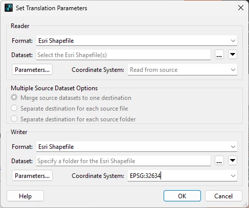
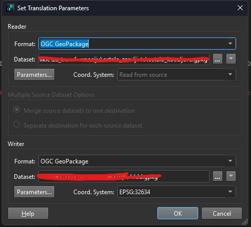
It is not any transformer.

It if FME Quick Translator, which can be invoked from Start menu, under "All Programs > FME Form oVersion] > FME Quick Translator," or by browsing to a file, right-clicking, and selecting "Translate with FME Quick Translator". 

Once you have the FME Quick Translator, go to File > Translate and you will see the dialog box as in my post with the Readers and Writers, which are to be set to Esri Shape File in your case.

Hope that helps.

Happy FME 🙂 -ing

Cheers

SRG


@raghavendrans 
I do get error’s from this screenshot above
And yes, i am trying with geopackage, i assume that the process is the same as for .shp

And my configuration is : 


@simeon.simic 

That is correct, the process is the same as SHP to SHP.

From the error screenshot, it looks like there is an issue while writing the output Geopackage.

For the Writer part, can you click the “Parameters” button to check if the settings are as below, but for the path of the output Geopackage file?


If you are trying to overwrite an existing file, I would suggest to try writing to a new file instead.

SRG


@raghavendrans 
Yes, the configuration is exactly the same as yours
I think that errors are because i dont have a schema, i just have one column with fid from QGis, maybe that’s the problem


Does it work for Geopackage to Esri Shape file?


@raghavendrans 

Yes, i tried it now and it works that way 


Does the Shape file have the necessary schema?

You could then try Esri Shape to OGC Geopackage, if that helps using FME.


@raghavendrans 
Thank you very much on your help

Do you maybe know after i change coordinate system
What should i open, or set, so that i can add parameters of my map that i  use?
Because i got what i need, but it doesnt show the right way on my map


@simeon.simic 

Are you asking what parameters to set for Esri Shape file to OGC Geopackage?

Was Esri Shape to OGC Geopackage successful with the Geopackage in EPSG 32634?

Did you try opening the output Geopackage in FME Data Inspector and see if the data is in EPSG 32634?

When you say “but it doesnt show the right way on my map”, what is the application you are using to view this data?

SRG


I Use QGis to view data, but that why i am asking about transformation, because i couldnt find a way, but with quick translator i change coordinate system which suits me, but i cannot get right when i insert in Qgis
In Qgis i use OpenStreetMap


A little out of topic, in QGIS, if you are opening the dataset in EPSG 32634, then depending on the frame settings, the coordinate system will automatically be set to EPSG 32634 for the QGIS project or reprojected to the default coordinate system settings of QGIS for the Map View.

You will find this under Settings>Options>CRS and Transforms

It will be good to consult the QGIS documentation for the specific version of QGIS to sort this issue.

SRG


@raghavendrans 

I found that, but i want to try to do everything in FME, and just to upload that file in QGis and when it’s uploaded to be all set how i need it to be 


@simeon.simic I completely understand.

Your data is already reprojected to the desired system by FME, which you have confirmed.

But for the view display in QGIS, there is nothing much FME can do!

Hope that solves your requirement.

Happy FME 🙂 ing

Cheers

SRG