Question

Maintain Source Raster File Name after converting to polygon

  • August 31, 2018
  • 3 replies
  • 25 views

londonhb185
Contributor
Forum|alt.badge.img

Hello,

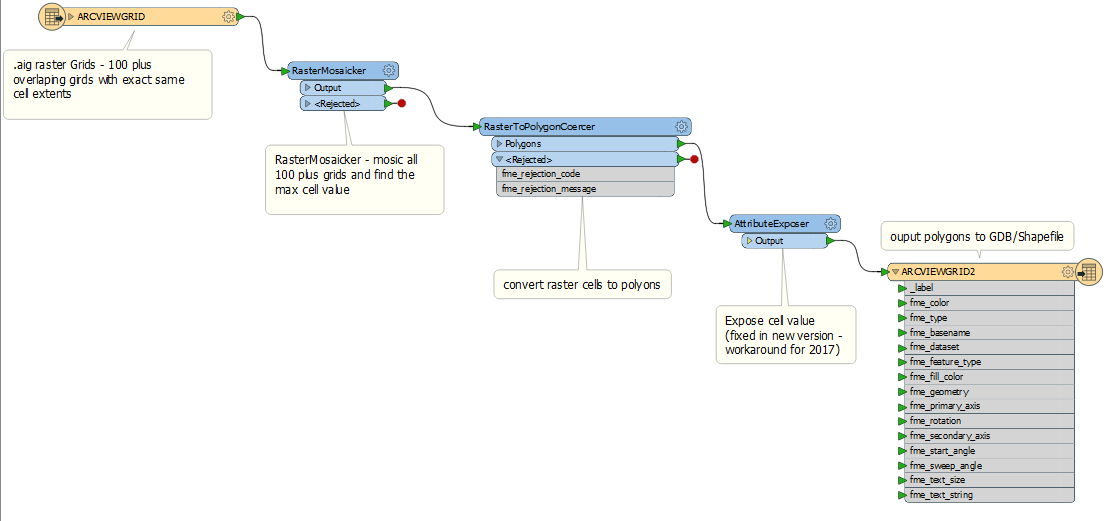
I am trying to maintain the source Raster name as an attribute that can be linked to the destination polygons once I have run a mosaic on all the rasters and converted them to polygons.

I have tried to generate a list on the RasterMosaicker, but still can't maintain the attribute.

Any ideas would be helpful

Thanks

Frank

This post is closed to further activity.
It may be an old question, an answered question, an implemented idea, or a notification-only post.
Please check post dates before relying on any information in a question or answer.
For follow-up or related questions, please post a new question or idea.
If there is a genuine update to be made, please contact us and request that the post is reopened.

3 replies

nathanatsafe
Safer
Forum|alt.badge.img+9
  • Safer
  • 284 replies
  • August 31, 2018

Hi @londonhb185,

Have you set your Accumulation Mode to "Merge Incoming Attributes" in the RasterMosaicker? Have you tried setting the Feature Type Name to "From File Name" and exposing fme_feature_type on your ARCVIEWGRID reader? You could also try creating a brand new attribute with this value, if you find that other transformers wipe out fme_feature_type. Hopefully this way you can build your list properly.


Hope this helps


Nathan

fmelizard
Safer
Forum|alt.badge.img+20
  • Safer
  • 3719 replies
  • September 1, 2018

Once you convert to polygons from the mosaic, won't some of the polygons potentially overlap / be derived from more than one raster? Feels like it would be hard to get the originating raster name perfectly. One idea would be to overlay the resulting polygons on the boundaries of the original rasters and then decide which one overlaps the most (can be done -- a bit tricky). Could you clarify a bit further how you want to determine the original source rastername?


arnold_bijlsma
Enthusiast
Forum|alt.badge.img+15
  • Enthusiast
  • 126 replies
  • May 2, 2019

Hi @londonhb185,

Have you set your Accumulation Mode to "Merge Incoming Attributes" in the RasterMosaicker? Have you tried setting the Feature Type Name to "From File Name" and exposing fme_feature_type on your ARCVIEWGRID reader? You could also try creating a brand new attribute with this value, if you find that other transformers wipe out fme_feature_type. Hopefully this way you can build your list properly.


Hope this helps


Nathan

When reading an Esri ASCII Grid, I had to expose the fme_dataset attribute, which gives me the full path and file name.