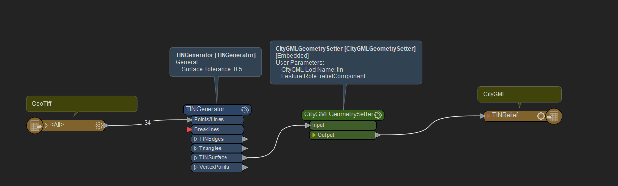
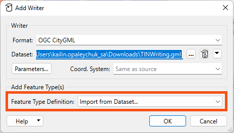
I want to convert a tiff to TINrelief in citygml. Is there a fmw workbench file or step by step guide for this? I’M a complete begineer to fme and citygml format.
Reader > TINGenerator (you can experiment with the tolerance to get a balance between detail and performance). You can take a look at the transformer help to get a good explanation of how the tolerance works. > CityGMLGeometrySetter > CityGML Writer.
Something like the below.

Reader > TINGenerator (you can experiment with the tolerance to get a balance between detail and performance). You can take a look at the transformer help to get a good explanation of how the tolerance works. > CityGMLGeometrySetter > CityGML Writer.
Something like the below.

Thanks
“<18:07:46 ERROR] Invalid content at n11, 10]: cvc-complex-type.2.4.a: Invalid content was found starting with element '{"http://www.opengis.net/citygml/relief/2.0":tin}'. One of '{"http://www.opengis.net/gml":metaDataProperty, "http://www.opengis.net/gml":description, "http://www.opengis.net/gml":name, "http://www.opengis.net/gml":boundedBy, "http://www.opengis.net/gml":location, "http://www.opengis.net/citygml/2.0":creationDate, "http://www.opengis.net/citygml/2.0":terminationDate, "http://www.opengis.net/citygml/2.0":externalReference, "http://www.opengis.net/citygml/2.0":generalizesTo, "http://www.opengis.net/citygml/2.0":relativeToTerrain, "http://www.opengis.net/citygml/2.0":relativeToWater, "http://www.opengis.net/citygml/2.0":_GenericApplicationPropertyOfCityObject, "http://www.opengis.net/citygml/relief/2.0":lod}' is expected.”
Does this mean I need to add more citygml related data to this? Could you please guide here?
Hello
Did you import the schema from dataset, as seen below?

When the import wizard pops up after clicking OK, leave the dataset blank and hit OK again. You will want to write to the ‘TINRelief’ feature type.
Now, if I went to write at this point, I would see a validation error that some elements were missing, sort of similar to what you were seeing from 3dcitydb.
To resolve this, add an AttributeCreator and set citygml_level_of_detail as ‘0’, ‘1’ or ‘2’ (for example).
These steps allowed me to produce a successful CityGML 2.0 dataset I can open in third party viewers. I’ve attached a workspace as an example. Let me know if you are still having issues! Happy to help, Kailin.