Question

Coercing output from RasterMosaicker to polygons performance issue

  • December 9, 2025
  • 3 replies
  • 117 views

mats.anderberg
Contributor
Forum|alt.badge.img+2

Hi,

I have 79 single-band rasters, each a step in a time series, with Int8 values that reprepresent a risk class. I want to get the max value for each cell and use a RasterMosaicker to achieve that. Then I use a RasterToPolygonCoercer to convert to polygons for further analysis. My problem is that converting the raster from the RasterMosaicker is extremely slow and performance demanding compared to converting the individual raster I have before the mosaicker (the timesteps are converted in a matter of seconds whereas the mosaicked raster takes in the range of an hour or more). This is an example of my workspace:

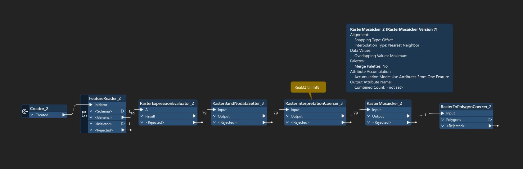
Why is it so much slower to convert the mosaicked raster? As far as I can see they have the same properties and dimensions. It does have more data but not by much and still most of the cells are nodata. Is there a faster way to achieve the same thing or am I missing something? Thanks!


3 replies

kailinatsafe
Safer
Forum|alt.badge.img+23

Hello ​@mats.anderberg, interesting use case, thanks for posting! I have a couple of questions that will help us better understand what's going on.

  • What version and build of FME Form are you using?
  • Can you explain what's happening in the RasterExpressionEvaluator?
  • What is the source format?

It may be helpful if you can share a few sample input rasters for testing purposes. Happy to help, Kailin.


mats.anderberg
Contributor
Forum|alt.badge.img+2
  • Author
  • Contributor
  • December 12, 2025

Hi ​@kailinatsafe, thanks for your reply! Unfortunately I can’t share any sample raster as it’s client property but it’s flooding data in geotiff format with two bands (water depth and water velocity). The RasterExpressionEvaluator calculates a risk class band based on the depth and velocity. Most of the cells get class 0 which is then set as nodata so most cells don’t have any data. For information the raster after the RasterMosaicker (which took a while to write) is around 32 MB (uncompressed) so it’s not a very large dataset. FME version is 2025.2.


kailinatsafe
Safer
Forum|alt.badge.img+23

Hello ​@mats.anderberg, sorry for not getting back to you sooner. A colleague and I thought a point cloud solution may give better performance, but didn’t yield expected results after testing. If you are willing to share sample datasets through a support case, we can take a closer look at the potential performance impacts stemming from the RasterMosiacker. Happy to help, Kailin.