
when I am using AnchoredSnapper 

Reader Cad civil 

Writer : oracle spatial 


Anchor : arcs

Candidate : points

Snapping Type : vertex Snapping 

it working fine


Anchor : arcs

Candidate : points

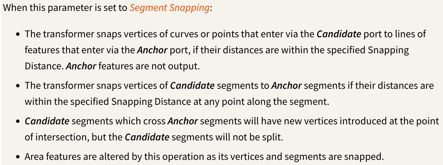
Snapping Type : Segment Snapping

Tolerance zero

error ORA-13347: the coordinates defining an arc are not distinct


same Snapping Distance in both


Why does this error occur when using Segment Snapping, The anchor is not supposed to move even with the Segment Snapping selected

The documentation explains segment snapping: snapping vertices of candidate points to their anchor, if their distances are within the specified snapping distance

“Snapping Distance” should to be set to be half the distance of the shortest line. Prior to AnchorSnapper, place a LengthCalculator and sort output length attribute to find the smallest length


Thank you 


I have no problem with that snapping vertices of candidate not points to their anchor, if their distances are not within the specified snapping distance


my problem is , why when using "Segment Snapping" with some arcs lead to change this arc , and raise an error when trying to insert that arc in databae


error ORA-13347: the coordinates defining an arc are not distinct


The anchor should not move in any way


yeah you may need to sample a single problem feature. Inspect it in the feature information window and in the visual preview map window. You may need a transformer like https://docs.safe.com/fme/html/FME-Form-Documentation/FME-Transformers/Transformers/arcstroker.htm to converts any arcs to a series of interpolated line segments.


yeah you may need to sample a single problem feature. Inspect it in the feature information window and in the visual preview map window. You may need a transformer like https://docs.safe.com/fme/html/FME-Form-Documentation/FME-Transformers/Transformers/arcstroker.htm to converts any arcs to a series of interpolated line segments.


thank you


but arcs is so important for me and ArcStroker change the curve of arcs


arcs are fine until they are used as an anchor from the AnchoredSnapper


unfortunately in FME terms arcs are not a Line geometry, which the segment snapping would use the line vertex…. so arc by bulge or 3dpoint can’t work with an anchor. The ArcStoker can be used to get the snapping working and you can also coercer or merge back the original arc feature


https://docs.safe.com/fme/html/FME-Form-Documentation/FME-ReadersWriters/!FME_Geometry/FME_Geometry_Model.htm


Thanks for your reply


but I don't know if it's because of the same explanation or not. Sometimes the SpatialRelator works well and sometimes it doesn't.


when :  

Supplier is fme_type : fme_arc 

and Requestor is fme_type : fme_point


functions : 

Requestor OGC-Intersects Supplier
Requestor OGC-Touches Supplier
Requestor OGC-Contains Supplier
Requestor is OGC-Within Supplier


Tester : incorrectly classifies some points outside the intersection range even though there is an intersection, and sometimes it classifies the correct intersection correctly.
On what standard can the ARC be used, or should it be avoided at all?


=================


If ArcEstimator  is used after ArcStroker , ARCs will it be returned to its original position completely as if I had not used ArcStroker, and thus the ARC will be insert into the database without any distortion in the curve? Is there a document for this? Thank you.


=================


and another question please


How can I keep the midpoint of the ARC ? After Reader reading the curves, the midpoint on which the ARC was built disappears (ArcBy3Points) - source Civil CAD File -

so the curve was reconstructed using the ArcEstimator , is it built on any basis?