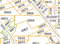
Hi,
I am trying to automate pdf map production, having used FME's Cartographic Output Workspace as the starting point.
I am unable to create a suitable civic address label for each parcel polygon. Most of the parcels are not perfect boxes, and are slightly rotated so I used a BoundingBoxReplacer (2D Oriented Bounding Box), Chopper, AzimuthCalculator (gets rotation of each side), LengthCalculator, Sorter (Sorts by civic address, then by segment length), Sampler (keeps longest side and the rotation), FeatureMerger (to bring the calculated rotation back to the original parcel shape. Using Labeller, LabelPointReplacer, or CenterPointReplacer and then TextAdder to create a central, upright label all fail.
An example of what I need the workspace to be able to produce:

Thanks!


