Question

British National Grid to WGS84 transformation causing shift

  • April 17, 2019
  • 10 replies
  • 215 views

  • 6 replies

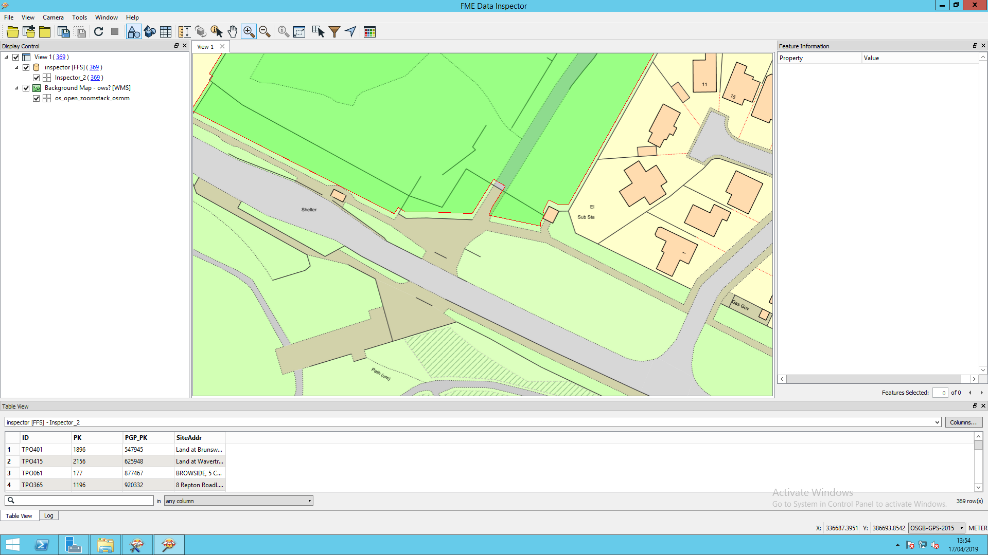
first step i have mapinfo tab file projected to OSGB-GPS-2015, when shown against a backdrop in ESPG:3857 a shift is noticeable and expected see below in universal translator


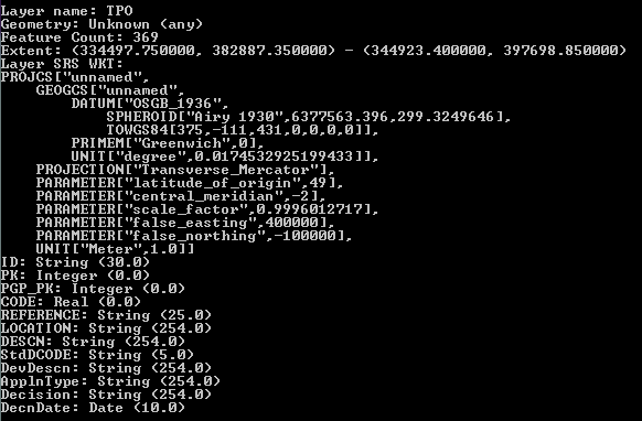
the ogr info for the mapinfo tab file is as below


Mapinfo:


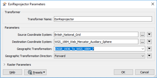
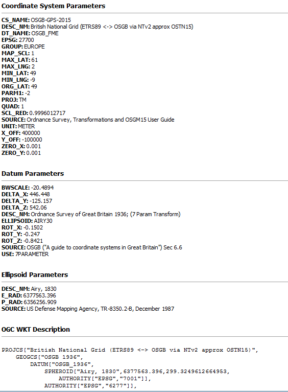
FME reads in the following manner


FME:


there appears to be a difference in the datums being applied.


this causes the shift to remain after transformation.


have tried a number of different transformations but it would appear this shift is present on initial reading of the tab file in FME.


is there a custom transformation and datum to prevent this shift?


if so how would this be applied to a workbench?


thanks in advance for any help.

This post is closed to further activity.
It may be an old question, an answered question, an implemented idea, or a notification-only post.
Please check post dates before relying on any information in a question or answer.
For follow-up or related questions, please post a new question or idea.
If there is a genuine update to be made, please contact us and request that the post is reopened.

10 replies

palhermans
Contributor
Forum|alt.badge.img+10
  • Contributor
  • 46 replies
  • April 17, 2019

@pk My take, the remaining shift probably means the 7-parameter transformation is too simple. At Ordnance Survey you can find a quite detailed documents for the best/official transformation: https://www.ordnancesurvey.co.uk/business-and-government/help-and-support/navigation-technology/os-net/formats-for-developers.html

A NTv2 file can be downloaded here: https://www.ordnancesurvey.co.uk/business-and-government/help-and-support/navigation-technology/os-net/ostn02-ntv2-format.html

And NTv2 may be incorporated in CsMapReprojector for You to define a custom reference system. A previous discussion: https://knowledge.safe.com/questions/3710/ntv2-transformation-using-own-data-grid.html

Might still be a shift, but at least the best available transformation has been used


  • Author
  • 6 replies
  • April 18, 2019

@pk My take, the remaining shift probably means the 7-parameter transformation is too simple. At Ordnance Survey you can find a quite detailed documents for the best/official transformation: https://www.ordnancesurvey.co.uk/business-and-government/help-and-support/navigation-technology/os-net/formats-for-developers.html

A NTv2 file can be downloaded here: https://www.ordnancesurvey.co.uk/business-and-government/help-and-support/navigation-technology/os-net/ostn02-ntv2-format.html

And NTv2 may be incorporated in CsMapReprojector for You to define a custom reference system. A previous discussion: https://knowledge.safe.com/questions/3710/ntv2-transformation-using-own-data-grid.html

Might still be a shift, but at least the best available transformation has been used


hello palhermans,


thanks for reply. yes I've actually tried the answer you supplied and indeed the shift is still apparent.


the thing is I need it to line up correctly for the purpose of the data is to see what properties within our local authority are within a tree preservation order scheme. whilst a small shift is unlikely to return incorrect results the visual shift is too apparent for our customer to find satisfactory.


we have the same data lined up with the back drop mapping fine in Qgis.


so my thinking is if that same transformation and datum can be applied from within FME then I may have a solution.


how I do this is my question really.


Thanks again


ebygomm
Influencer
Forum|alt.badge.img+44
  • Influencer
  • 3428 replies
  • April 18, 2019

So you are reading the data in which has the coordinate system set to OSGB-GPS-2015 and then reprojecting to ESPG:3857?

Are you using the Reprojector, or the CSMapReprojector or the EsriReprojector?


  • Author
  • 6 replies
  • April 18, 2019

So you are reading the data in which has the coordinate system set to OSGB-GPS-2015 and then reprojecting to ESPG:3857?

Are you using the Reprojector, or the CSMapReprojector or the EsriReprojector?


hello egomm,


thanks for reply yes data from the mapinfo tab file is OSGB-GPS-2015 and the reprojection is to ESPG:3857, have used both reprojector and CSmapreprojector and the GridInquest!!reprojector


thanks


ebygomm
Influencer
Forum|alt.badge.img+44
  • Influencer
  • 3428 replies
  • April 18, 2019

hello egomm,


thanks for reply yes data from the mapinfo tab file is OSGB-GPS-2015 and the reprojection is to ESPG:3857, have used both reprojector and CSmapreprojector and the GridInquest!!reprojector


thanks

And you definitely want the data stored in ESPG:3857 (Web Mercator) not in EPSG:4326 (WGS 84)?


  • Author
  • 6 replies
  • April 18, 2019

And you definitely want the data stored in ESPG:3857 (Web Mercator) not in EPSG:4326 (WGS 84)?


hello egomm,


thanks again for reply, sorry what is actually the case is we are trying to store in EPSG:4326 but displaying in EPSG:3857


ebygomm
Influencer
Forum|alt.badge.img+44
  • Influencer
  • 3428 replies
  • April 18, 2019

hello egomm,


thanks again for reply, sorry what is actually the case is we are trying to store in EPSG:4326 but displaying in EPSG:3857

So if you store in EPSG:4326 and display in your web mapping system do you see the same shift? I think i might not trust the inspector on this one


  • Author
  • 6 replies
  • April 23, 2019

So you are reading the data in which has the coordinate system set to OSGB-GPS-2015 and then reprojecting to ESPG:3857?

Are you using the Reprojector, or the CSMapReprojector or the EsriReprojector?


Hello egomm,


sorry for the length of time to reply.


unfortunately can almost certainly rule out the data inspector as the shift is present when viewed as we expect to publish via, our mapping application.


Below is a screen of the same data, red bordered polygons lining up perfectly against the same backdrop mapping in Qgis.


So put simply the need is to replicate how Qgis handles this particular projection and datum.


the issue here that being a Local Authority in UK, this is intended for public consumption and as the failure to adhere to the boundaries as displayed as polygons could lead to prosecution as the data relates specifically to Tree Preservation Orders, therefore the accuracy is of the utmost importance.


Thanks again for efforts so far. PK


palhermans
Contributor
Forum|alt.badge.img+10
  • Contributor
  • 46 replies
  • April 23, 2019

Hello egomm,


sorry for the length of time to reply.


unfortunately can almost certainly rule out the data inspector as the shift is present when viewed as we expect to publish via, our mapping application.


Below is a screen of the same data, red bordered polygons lining up perfectly against the same backdrop mapping in Qgis.


So put simply the need is to replicate how Qgis handles this particular projection and datum.


the issue here that being a Local Authority in UK, this is intended for public consumption and as the failure to adhere to the boundaries as displayed as polygons could lead to prosecution as the data relates specifically to Tree Preservation Orders, therefore the accuracy is of the utmost importance.


Thanks again for efforts so far. PK

Hi PK, might be I am totally out here, but what software is used for the mapping application? To me it looks like a 7-parameter transformation is reapplied but should not be necessary if data are EPSG:4326 stored and appliaction ins EPSG:3857. You are certain the data have attached a correct code for the reference system?


arnold_bijlsma
Enthusiast
Forum|alt.badge.img+15
  • Enthusiast
  • 126 replies
  • April 24, 2019

When converting between British National Grid and WGS84, use the EsriReprojector and choose transformation number 7: