Question

NAS2Shape


Hey,

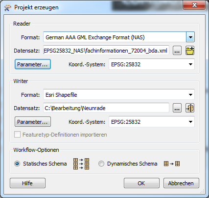
i like to transform NAS Files ((German AAA GML Exchange Format(NAS) OpenData like fachinformation_11001_dba.xml) in a shapefile that can i open with a GIS program.

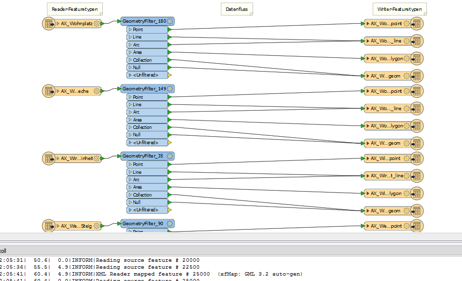
In total, i have 65 NAS Files, the problem i got is, i need for every file a new reader and writer, is it posiible to transform the data with one reader and one writer ? The filename can be the same, like this...

fachinformation_11001.xml ----> fachinformation_11001.shx (simplified)

Regards

Kai


4 replies

redgeographics
Celebrity
Forum|alt.badge.img+48

You could start by using the Generate Workspace option, select all your NAS files and specify Shape as output.

However, due to some peculiarities in the shapefile spec (only one type of geometry per file and max 10 characters for attribute names) this dynamic approach may not be what you want. So if you have special concerns with regards to the output schema you may want to finetune the workspace that's being generated.


  • Author
  • November 2, 2018

@redgeographics

Thank you for your answer.

i made it, like you said.

Now i got this workflow...

But it wont work, i got this message.


2018-11-02 12:07:48| 187.2| 5.3|INFORM|XML Reader mapped feature # 85000 (xfMap: GML 3.2 auto-gen)

2018-11-02 12:07:48| 187.2| 0.0|INFORM|Reading source feature # 85000

2018-11-02 12:07:51| 190.3| 3.0|ERROR |DBF Writer: DBF file exceeds maximum size of 2 GB

2018-11-02 12:07:51| 190.3| 0.0|ERROR |Unable to output data to file 'C:\\Bearbeitung\\Neunrade\\AX_Gebaeude_polygon.dbf'

2018-11-02 12:07:51| 190.3| 0.0|ERROR |Unable to output data to file 'C:\\Bearbeitung\\Neunrade\\AX_Gebaeude_polygon.dbf'

2018-11-02 12:07:51| 190.3| 0.0|ERROR |Destination Feature Type Routing Correlator(RoutingFactory): Unable to output data to file 'C:\\Bearbeitung\\Neunrade\\AX_Gebaeude_polygon.dbf'

2018-11-02 12:07:51| 190.3| 0.0|INFORM|=-=-=-=-=-=-=-=-=-=-=-=-=-=-=-=-=-=-=-=-=-=-=-=-=-=-=-=-=-=-=-=-=-=-=-=-=-=-=-

2018-11-02 12:07:51| 190.3| 0.0|INFORM|Feature output statistics for `FFS' writer using keyword `W_1':

2018-11-02 12:07:51| 190.3| 0.0|STATS |=-=-=-=-=-=-=-=-=-=-=-=-=-=-=-=-=-=-=-=-=-=-=-=-=-=-=-=-=-=-=-=-=-=-=-=-=-=-=-

2018-11-02 12:07:51| 190.3| 0.0|STATS | Features Written

2018-11-02 12:07:51| 190.3| 0.0|STATS |=-=-=-=-=-=-=-=-=-=-=-=-=-=-=-=-=-=-=-=-=-=-=-=-=-=-=-=-=-=-=-=-=-=-=-=-=-=-=-

2018-11-02 12:07:51| 190.3| 0.0|STATS |==============================================================================

2018-11-02 12:07:51| 190.3| 0.0|STATS |Total Features Written 0

2018-11-02 12:07:51| 190.3| 0.0|STATS |=-=-=-=-=-=-=-=-=-=-=-=-=-=-=-=-=-=-=-=-=-=-=-=-=-=-=-=-=-=-=-=-=-=-=-=-=-=-=-

2018-11-02 12:07:51| 190.3| 0.1|ERROR |DBF Writer: DBF file exceeds maximum size of 2 GB

Fehler beim Ausführen der Umsetzung.


Did you now a waay to avoid this message ?


Have a nice weekend

Kai


redgeographics
Celebrity
Forum|alt.badge.img+48
kai_himself wrote:

@redgeographics

Thank you for your answer.

i made it, like you said.

Now i got this workflow...

But it wont work, i got this message.


2018-11-02 12:07:48| 187.2| 5.3|INFORM|XML Reader mapped feature # 85000 (xfMap: GML 3.2 auto-gen)

2018-11-02 12:07:48| 187.2| 0.0|INFORM|Reading source feature # 85000

2018-11-02 12:07:51| 190.3| 3.0|ERROR |DBF Writer: DBF file exceeds maximum size of 2 GB

2018-11-02 12:07:51| 190.3| 0.0|ERROR |Unable to output data to file 'C:\\Bearbeitung\\Neunrade\\AX_Gebaeude_polygon.dbf'

2018-11-02 12:07:51| 190.3| 0.0|ERROR |Unable to output data to file 'C:\\Bearbeitung\\Neunrade\\AX_Gebaeude_polygon.dbf'

2018-11-02 12:07:51| 190.3| 0.0|ERROR |Destination Feature Type Routing Correlator(RoutingFactory): Unable to output data to file 'C:\\Bearbeitung\\Neunrade\\AX_Gebaeude_polygon.dbf'

2018-11-02 12:07:51| 190.3| 0.0|INFORM|=-=-=-=-=-=-=-=-=-=-=-=-=-=-=-=-=-=-=-=-=-=-=-=-=-=-=-=-=-=-=-=-=-=-=-=-=-=-=-

2018-11-02 12:07:51| 190.3| 0.0|INFORM|Feature output statistics for `FFS' writer using keyword `W_1':

2018-11-02 12:07:51| 190.3| 0.0|STATS |=-=-=-=-=-=-=-=-=-=-=-=-=-=-=-=-=-=-=-=-=-=-=-=-=-=-=-=-=-=-=-=-=-=-=-=-=-=-=-

2018-11-02 12:07:51| 190.3| 0.0|STATS | Features Written

2018-11-02 12:07:51| 190.3| 0.0|STATS |=-=-=-=-=-=-=-=-=-=-=-=-=-=-=-=-=-=-=-=-=-=-=-=-=-=-=-=-=-=-=-=-=-=-=-=-=-=-=-

2018-11-02 12:07:51| 190.3| 0.0|STATS |==============================================================================

2018-11-02 12:07:51| 190.3| 0.0|STATS |Total Features Written 0

2018-11-02 12:07:51| 190.3| 0.0|STATS |=-=-=-=-=-=-=-=-=-=-=-=-=-=-=-=-=-=-=-=-=-=-=-=-=-=-=-=-=-=-=-=-=-=-=-=-=-=-=-

2018-11-02 12:07:51| 190.3| 0.1|ERROR |DBF Writer: DBF file exceeds maximum size of 2 GB

Fehler beim Ausführen der Umsetzung.


Did you now a waay to avoid this message ?


Have a nice weekend

Kai

You're running in to another limitation of shapefiles: the .dbf file used to store the attribute can't be more than 2 Gb in size.

There's a few things you can do:

  1. Not write to a shapefile :) (but something else)
  2. Remove any attributes you're not interested in.
  3. Tile the data.
  4. Divide the buildings (that's the most likely layer to have this kind of problems) into chunks. If you read just the buildings and take note of the amount that can be written before you get the error you can use the Grouper custom transformer (turns out I made that, I had forgotten all about it) to divide the full set of buildings into smaller sets (keeping below that amount, with a safety margin). You'll need to use the

I'd also recommend you vote on this idea.


  • Author
  • November 5, 2018

@redgeographics

Thank you for your answer. I will try it and get back to you later. P. S. I vote for the automatically tile :)


Regards Kai


Cookie policy

We use cookies to enhance and personalize your experience. If you accept you agree to our full cookie policy. Learn more about our cookies.

 
Cookie settings