GDAL has a pretty handy proximity calculator where each pixel in the output raster represents the distance to the nearest pixel in the input raster. For instance, distance to the nearest road. Is there any transformer doing that in FME ? Thanks!

Best answer by fiorinoh
Hi @fiorinoh,
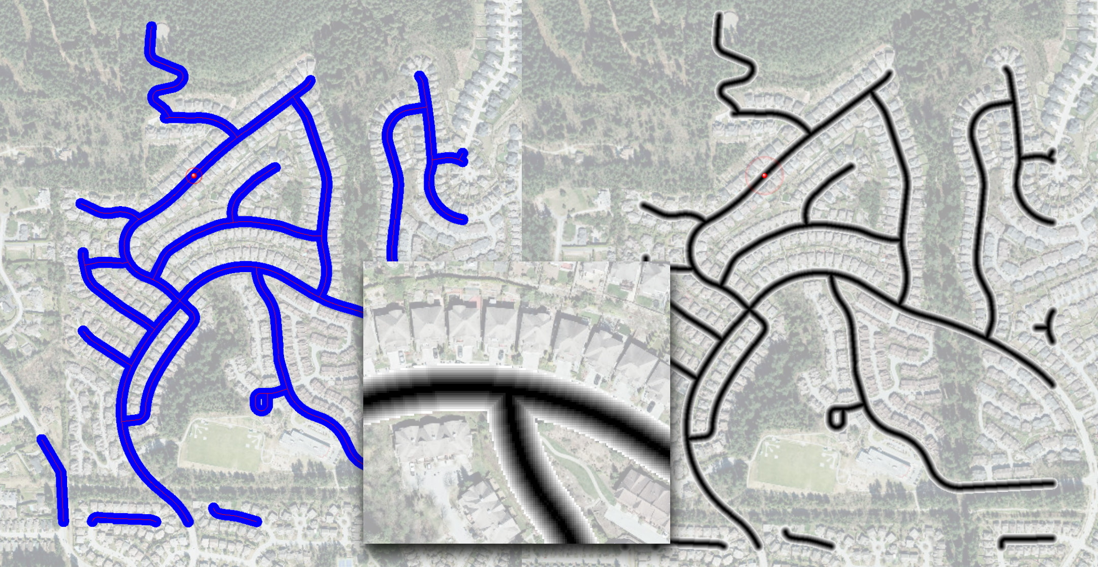
I think, we can do it using standard FME tools. Here is how I did it - first, I generate a distance raster where each pixel represents the distance between the center pixel and all other pixels (I use a point cloud approach for this). Then, I turn all the road network pixels to points and pass my distance raster to them. Then, I mosaic all rasters together using minimal pixel values for overlapping rasters. As a last step, I deal with pixels beyond Distance parameter setting them to NoData. I tried to do this with the original distance raster, but somehow, it significantly affects performance (we'll investigate).
I used the road network of the city where I live. Once rasterized (1m resolution), it creates over 144,000 pixels representing roads.
My laptop generates the output in 1 minute if I set distance to 200 meters (400x400 distance raster), in 2.5 minutes with 400 meters (800x800 pixels), and under 4 minutes for 500 m distance (1000x1000 pixels). The final raster is about 8K pixels along each side.
I'll see whether we can compare it somehow with the GDAL proximity calculator. I also can make a custom transformer from this workspace if you think this method does what you expect and its performance is reasonable. See the attached template. It was made with FME 2022, but it opens and runs with FME 2021.2 as well.
Dmitri
Hi @dmitribagh , this is my last solution to this issue. As it is not easy to compute proximity rasters with FME transformers, I decided to use a python caller + GDAL. That was not easy because FME raster type and GDAL raster type are not compatible. Hope this code will help the FME community. BR.
import fmeobjects
import numpy as np
from osgeo import gdal

class MyBandTilePopulator(fmeobjects.FMEBandTilePopulator):
    """
    This is a subclass of the FMEBandTilePopulator superclass.
    It will be used when data is requested to create a new tile and
    and populate it to a new FMEBand.
    """
    def __init__(self, rasterData):
        self._rasterData = rasterData

    # required method
    def clone(self):
        """
        This method is used to create a copy of the data
        multiple times while creating a new band
        """
        return MyBandTilePopulator(self._rasterData)

    # required method
    def getTile(self, startRow, startCol, tile):
       """
       Creates a new tile that's sized based on the input tile.
       Populates that tile using this populator's raster data beginning
       at the startRow and startCol.
       """
       numRows, numCols = tile.getNumRows(), tile.getNumCols()
       newTile = fmeobjects.FMEUInt16Tile(numRows, numCols)
       data = newTile.getData()
       for row in range(startRow, startRow+numRows):
           for col in range(startCol, startCol+numCols):
               if row < len(self._rasterData) and col < len(self._rasterData[0]):
                   data[row - startRow][col - startCol] = self._rasterData[row][col]
       newTile.setData(data)
       return newTile


class FeatureProcessor(object):
    def __init__(self):
        self.rasterData = []

    def input(self, feature):

        self.sysRef = feature.getCoordSys()
        raster = feature.getGeometry()
        rp = raster.getProperties()
        band = raster.getBand(0)

        bp = band.getProperties()
        print("=== FME Input Raster ===")
        print("Coordinate System = " + self.sysRef)
        self.pixelWidth = rp.getSpacingX()
        print("pixelWidth = " + str(self.pixelWidth))
        self.pixelHeight = rp.getSpacingY()
        print("pixelHeight = " + str(self.pixelHeight))
        self.originX = rp.getOriginX()
        print("originX = " + str(self.originX))
        self.originY = rp.getOriginY()
        print("originY = " + str(self.originY))
        numRows = rp.getNumRows()
        print("numRows = " + str(numRows))
        numCols = rp.getNumCols()
        print("numCols = " + str(numCols))
        print("===")

        tile = fmeobjects.FMEGray16Tile(numRows, numCols)
        bandData = band.getTile(0, 0, tile).getData()
        array = np.array(bandData)

        driver = gdal.GetDriverByName('GTiff')
        num_of_bands = 1
        print("Creating file raster_transportation_roads.tiff")
        srcRaster = driver.Create('raster_transportation_roads.tiff', numCols, numRows, num_of_bands, gdal.GDT_UInt16)
        srcRaster.SetGeoTransform((self.originX, self.pixelWidth, 0, self.originY, 0, self.pixelHeight))
        srcBand = srcRaster.GetRasterBand(1)
        srcBand.WriteArray(array)
        srcBand.FlushCache()
        srcBand = None
        srcRaster = None

        src_ds = gdal.Open('raster_transportation_roads.tiff')
        geotransform = src_ds.GetGeoTransform()
        srcBand = src_ds.GetRasterBand(1)
        print("Origin = ({}, {})".format(geotransform[0], geotransform[3]))
        print("Pixel Size = ({}, {})".format(geotransform[1], geotransform[5]))
        print("===")

        print("Creating file proximity_transportation_roads.tiff with GDAL")
        dst_filename='proximity_transportation_roads.tiff'
        drv = gdal.GetDriverByName('GTiff')
        dst_ds = drv.Create(dst_filename, numCols, numRows, num_of_bands, gdal.GetDataTypeByName('UInt16'))
        dst_ds.SetGeoTransform(geotransform)
        dst_ds.SetProjection(src_ds.GetProjectionRef())
        dstBand = dst_ds.GetRasterBand(1)

        gdal.ComputeProximity(srcBand, dstBand, ["DISTUNITS=PIXEL"])
        self.rasterData = dstBand.ReadAsArray().tolist()

        dstBand.FlushCache()
        dstBand = None
        srcBand = None
        print("===")

    def close(self):

        # creating the raster data and specifying the formatting of the new raster
        rasterData = self.rasterData


        # specifying all of the properties for the new FMERaster
        numRows, numCols = len(rasterData), len(rasterData[0])
        xCellOrigin, yCellOrigin = 0.5, 0.5
        xSpacing, ySpacing = self.pixelWidth, self.pixelHeight
        xOrigin, yOrigin = self.originX, self.originY
        xRotation, yRotation = 0.0, 0.0

        # creating the new FMERaster
        rasterProperties = fmeobjects.FMERasterProperties(numRows, numCols,
                                                          xSpacing, ySpacing,
                                                          xCellOrigin, yCellOrigin,
                                                          xOrigin, yOrigin,
                                                          xRotation, yRotation)
        raster = fmeobjects.FMERaster(rasterProperties)

        # Populating the contents of the band and appending it to the raster
        bandTilePopulator = MyBandTilePopulator(rasterData)
        bandName = ''
        bandProperties = fmeobjects.FMEBandProperties(bandName,
                                                      fmeobjects.FME_INTERPRETATION_UINT16,
                                                      fmeobjects.FME_TILE_TYPE_FIXED,
                                                      numRows, numCols)
        band = fmeobjects.FMEBand(bandTilePopulator, rasterProperties,
                                  bandProperties)
        raster.appendBand(band)

        # creating a new feature with the FMERaster geometry to be output
        feature = fmeobjects.FMEFeature()
        feature.setGeometry(raster)
        feature.setCoordSys(self.sysRef)
        self.pyoutput(feature)


    def process_group(self):
        """When 'Group By' attribute(s) are specified, this method is called
        once all the FME Features in a current group have been sent to input().

        FME Features sent to input() should generally be cached for group-by
        processing in this method when knowledge of all Features is required.
        The resulting Feature(s) from the group-by processing should be emitted
        through self.pyoutput().

        FME will continue calling input() a number of times followed
        by process_group() for each 'Group By' attribute, so this
        implementation should reset any class members for the next group.
        """
        pass
It may be an old question, an answered question, an implemented idea, or a notification-only post.
Please check post dates before relying on any information in a question or answer.
For follow-up or related questions, please post a new question or idea.
If there is a genuine update to be made, please contact us and request that the post is reopened.


")