Question

Civic Address Label

  • December 17, 2019
  • 2 replies
  • 15 views

dmerrick
Contributor
Forum|alt.badge.img+1

Hi,

I am trying to automate pdf map production, having used FME's Cartographic Output Workspace as the starting point.


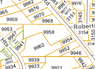
I am unable to create a suitable civic address label for each parcel polygon. Most of the parcels are not perfect boxes, and are slightly rotated so I used a BoundingBoxReplacer (2D Oriented Bounding Box), Chopper, AzimuthCalculator (gets rotation of each side), LengthCalculator, Sorter (Sorts by civic address, then by segment length), Sampler (keeps longest side and the rotation), FeatureMerger (to bring the calculated rotation back to the original parcel shape. Using Labeller, LabelPointReplacer, or CenterPointReplacer and then TextAdder to create a central, upright label all fail.

An example of what I need the workspace to be able to produce:

Thanks!

2 replies

daveatsafe
Safer
Forum|alt.badge.img+19
  • Safer
  • December 17, 2019

Hi @dmerrick,

It is an extra-cost option, but you might want to try the MapTextLabeller transformer, which does have a sophisticated labelling algorithm.More information, and a 30 day trial can be found at https://www.safe.com/solutions/specialty/maptextlabeller-transformer/


dmerrick
Contributor
Forum|alt.badge.img+1
  • Author
  • Contributor
  • December 24, 2019
daveatsafe wrote:

Hi @dmerrick,

It is an extra-cost option, but you might want to try the MapTextLabeller transformer, which does have a sophisticated labelling algorithm.More information, and a 30 day trial can be found at https://www.safe.com/solutions/specialty/maptextlabeller-transformer/

Thanks @daveatsafe, I was wanting to avoid the extra-cost option and use the in-house transformers for the job.


Cookie policy

We use cookies to enhance and personalize your experience. If you accept you agree to our full cookie policy. Learn more about our cookies.

 
Cookie settings