
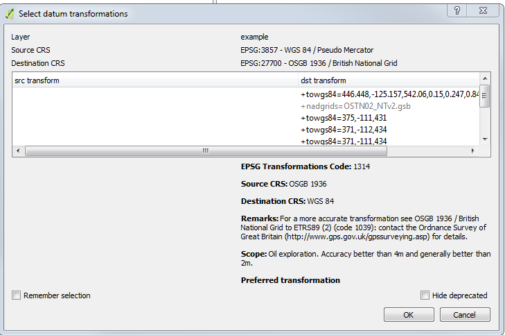
The QGIS transformation appears to be named as EPSG:1314. https://epsg.io/1314 so I thought I could transform the data with that to 4326, before sending to the 3DTiles writer. However, I can't find epsg:1314 as a transformation in the csMapReprojector in FME, and none of the available OSGB_to_WGS84 transforms give any better results. So do I need to recreate the transformation parameters of 1314 myself? Or is there another approach. I find it surprising that FME does not have this transformation already so I am starting to wonder if I am either missing something obvious or my approach is flawed.

Solved
Datum transformation differences QGIS and FME osgb to wgs84
Hi all,
I've done some data preparation of OpenStreetMap data (epsg:4326) in QGIS and as part of that work reprojected the OSM data to epsg:27700, naughtily relying on QGIS on the fly reprojection without too much thought. That defaults to a transformation that looks good in QGIS for my purposes and aligns well with the OSM web tiles in QGIS. I now want to use the 3DTiles in FME visualisation to export the data as a Cesium web map (thus going back from epsg 27700 to 4326) but I see a shift of about 1m or 2m of my OSM data when in Cesium (i.e. the product of the FME writer). I presume this is because FME is doing a different transformation to go back (appears to default to using OSTN15 grid shift) to that which I applied in QGIS.
Best answer by daveatsafe
Hi @maptopixel,
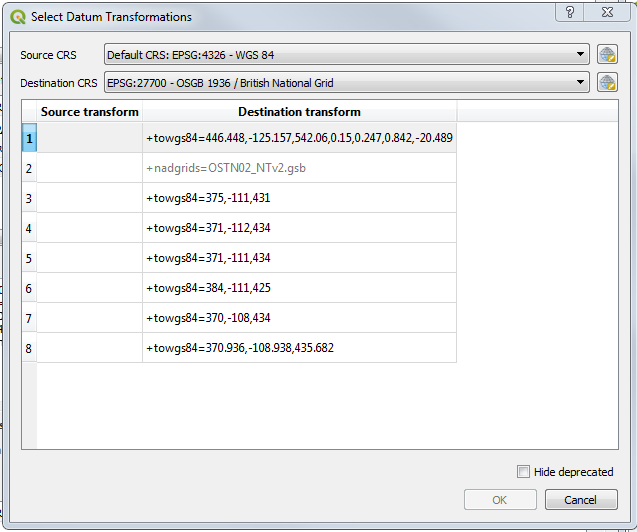
I'm sorry, but this transformation is not shipped with FME, since most users want the more accurate grid transformation.
I have created a couple of definitions for you:
OSGB1936_to_WGS84_7Param - uses 7 parameter algorithm
OSGB1936_to_WGS84_Bursa - use Bursa Wolf 7 parameter approximation
I'm not sure which algorithm QGIS uses for the transformation, so I provided both. One of them should match the QGIS transformation.
Please copy the attached file into your Documents\\FME\\CoordinateSystems folder to make the transformations available to FME.


Reply
Rich Text Editor, editor1
Editor toolbars
Press ALT 0 for help
Helpful Members This Week


Enter your E-mail address. We'll send you an e-mail with instructions to reset your password.