Solved

Geotiff boundries

  • October 9, 2018
  • 1 reply
  • 36 views

Hey all,

I'm just recently working with FME. We are using fme for converting xyz pointclouds to geotiff format. Converting is not longer a problem (thanks to the fast help here).

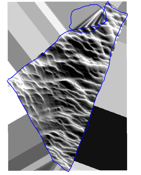
But now i'm looking how i can set a boundrie for the geotiff. (drawn in blue)


As you will see in picture i have added here the geotiff also gives elevation where there is no data. (blue circle).

I know that in C3D i can set a boundrie for the geotiff or give a max triangle length(witch is not the best solution but also works for this problem). Is there anything like that possible in FME?

Many thanks,

Koen

Best answer by takashi

Hi @venkenk, I suppose that you created the raster with the RasterDEMGenerator.

If you create another raster with the NumericRasterizer (Fill Background with Nodata: Yes) from the same point cloud, you can convert it to a polygon representing the data area with the RasterExtentsCoercer (Extents Type: Data Extents). You can then clip the current DEM raster by the polygon to get rid of the unnecessary part.

Note: Depending on the data condition and parameters setting in the NumericRasterizer, the RasterExtentsCoercer could create an aggregate (multi-part polygon) or a donut (having holes). Maybe you will have to determine the parameters in the NumericRasterizer with trial and error and/or use some additional transformers such as DonutHoleExtractor in order to clean the polygon up.

View original
Did this help you find an answer to your question?

1 reply

takashi
Influencer
  • Best Answer
  • October 9, 2018

Hi @venkenk, I suppose that you created the raster with the RasterDEMGenerator.

If you create another raster with the NumericRasterizer (Fill Background with Nodata: Yes) from the same point cloud, you can convert it to a polygon representing the data area with the RasterExtentsCoercer (Extents Type: Data Extents). You can then clip the current DEM raster by the polygon to get rid of the unnecessary part.

Note: Depending on the data condition and parameters setting in the NumericRasterizer, the RasterExtentsCoercer could create an aggregate (multi-part polygon) or a donut (having holes). Maybe you will have to determine the parameters in the NumericRasterizer with trial and error and/or use some additional transformers such as DonutHoleExtractor in order to clean the polygon up.


Cookie policy

We use cookies to enhance and personalize your experience. If you accept you agree to our full cookie policy. Learn more about our cookies.

 
Cookie settings