
How to get Shape files to convert to DWG with elevations?
- December 20, 2017
- 23 replies
- 279 views

It may be an old question, an answered question, an implemented idea, or a notification-only post.
Please check post dates before relying on any information in a question or answer.
For follow-up or related questions, please post a new question or idea.
If there is a genuine update to be made, please contact us and request that the post is reopened.
23 replies


 +21
+21- Safer
- December 20, 2017

Hi @caddrafter, have you had a chance to review How to convert SHP to DWG (Esri Shapefile to AutoCAD)? This is a tutorial guiding you how to do the translation.
- Author
- December 20, 2017
Hi, yes I did watch it, a few times in fact. The shape file gets converted but there are no elevations on the contours. I'm downloading lidar contours which we've been able to import into Carlson Survey and output as a DWG file. Problem is we only have one seat of it, which is in the office, and I work remotely so I'm trying to find an alternate method.

 +9
+9- Safer
- December 20, 2017
Hi @caddrafter
Have you tried using the 3DForcer to force your Shapefile into 3 dimensions? If that doesn't work, uploading a sample dataset and/or workspace might help troubleshoot the translation.
Thanks!
- Author
- December 29, 2017
Thanks Nathan. I haven't had an opportunity to try that out yet but I'll let you know when I do and what the results are.
Thanks,
- Author
- December 29, 2017
Hi @caddrafter
Have you tried using the 3DForcer to force your Shapefile into 3 dimensions? If that doesn't work, uploading a sample dataset and/or workspace might help troubleshoot the translation.
Thanks!
Thanks Nathan. I haven't had an opportunity to try that out yet but I'll let you know when I do and what the results are.
Thanks,
+21- Safer
- December 29, 2017
The 3DForcer will make your polylines all 3D, which might be what you want. It is also possible to use the "autocad_elevation" format attribute on your DWG writer to set that elevation property on a 2d polyline. This uses less space in the output DWG. All depends on what you want created.
Check the documentation on this at https://docs.safe.com/fme/html/FME_Desktop_Documentation/FME_ReadersWriters/acad/Lines.htm and see screenshot below as to how to expose this:
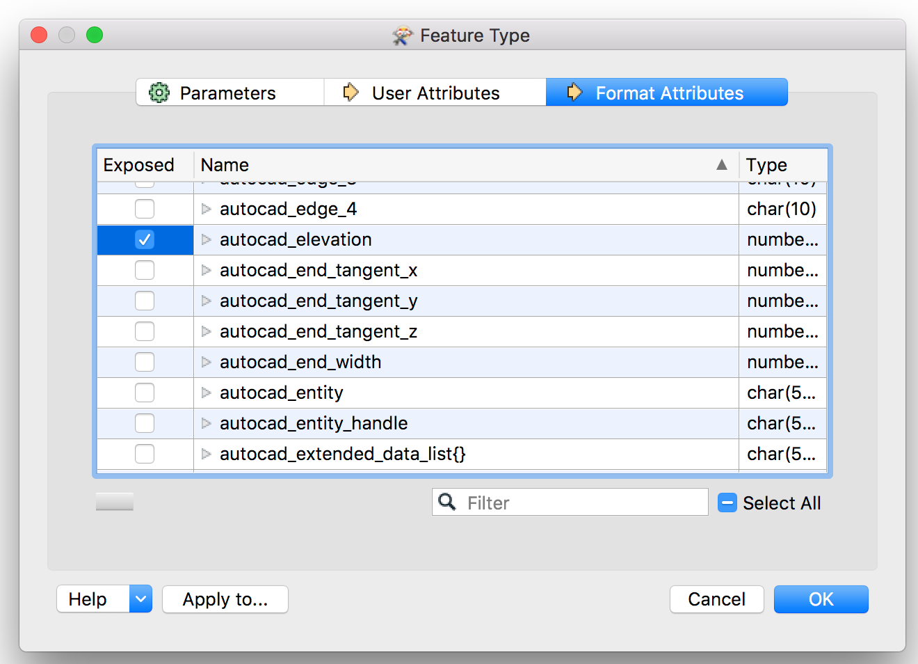
(Really you could also just rename the elevation attribute you read from Shape to autocad_elevation and it would work too)
- Author
- January 23, 2018
The 3DForcer will make your polylines all 3D, which might be what you want. It is also possible to use the "autocad_elevation" format attribute on your DWG writer to set that elevation property on a 2d polyline. This uses less space in the output DWG. All depends on what you want created.
Check the documentation on this at https://docs.safe.com/fme/html/FME_Desktop_Documentation/FME_ReadersWriters/acad/Lines.htm and see screenshot below as to how to expose this:
(Really you could also just rename the elevation attribute you read from Shape to autocad_elevation and it would work too)
- Author
- January 24, 2018
Hi @caddrafter
Have you tried using the 3DForcer to force your Shapefile into 3 dimensions? If that doesn't work, uploading a sample dataset and/or workspace might help troubleshoot the translation.
Thanks!
Thanks!
+21- Safer
- January 24, 2018
Hi @caddrafter -- check out the attached template example. If you run it in FME 2017.1 or later, you should get elevation set in the resulting DWG file. Hopefully that then can be modified for your input.
- Author
- March 26, 2018
I still can't get this to work and I've been trying for hours. I have to say customer service is pretty lousy seeing how I can't find any resolution since my original question back in December. I've tried all the suggestions and I still can't get the elevations! When I add the "elevation" attribute it still doesn't appear like the example shown. Very frustrating.

 +10
+10- March 26, 2018
+10- March 26, 2018
I still can't get this to work and I've been trying for hours. I have to say customer service is pretty lousy seeing how I can't find any resolution since my original question back in December. I've tried all the suggestions and I still can't get the elevations! When I add the "elevation" attribute it still doesn't appear like the example shown. Very frustrating.
Having that said, I just curious whether your shapefile is 3D, or is it 2D and does it have a height attribute?
Also you can share your workspace, which would allow us to have a look at it and see if you did something wrong there. Sometimes even without having the source data at hand.
- Author
- March 26, 2018
I still can't get this to work and I've been trying for hours. I have to say customer service is pretty lousy seeing how I can't find any resolution since my original question back in December. I've tried all the suggestions and I still can't get the elevations! When I add the "elevation" attribute it still doesn't appear like the example shown. Very frustrating.
I can't blame the seller because I have a 6 month free trial. I certainly am not inclined to purchase at this rate.
It is 2D Lidar contours, no 3D. The contours will convert but everything is assigned a 0 elevation.
- Author
- March 26, 2018
+10- March 27, 2018
I can't blame the seller because I have a 6 month free trial. I certainly am not inclined to purchase at this rate.
It is 2D Lidar contours, no 3D. The contours will convert but everything is assigned a 0 elevation.
Looking again at your issue, have you checked the ELEVATION attribute for having the right values? If those values are 0, no way your contours will get an elevation.
Again, it would be helpfull if you share (a subset of) your data and or your workspace.
- Author
- March 27, 2018
I still can't get this to work and I've been trying for hours. I have to say customer service is pretty lousy seeing how I can't find any resolution since my original question back in December. I've tried all the suggestions and I still can't get the elevations! When I add the "elevation" attribute it still doesn't appear like the example shown. Very frustrating.
output-26.zip
+10- March 27, 2018
Hi @caddrafter,
this simple workspace creates the 3D elevation lines and writes them to AutoCAD DWG. I have checked the output and the lines are in 3D.
Attached are both the workspace (esrishape2realdwg.fmw) and the DWG (elevation.dwg) I created.
Hopes this will make it possible for you to create your output.
- Author
- March 27, 2018
Hi @caddrafter,
this simple workspace creates the 3D elevation lines and writes them to AutoCAD DWG. I have checked the output and the lines are in 3D.
Attached are both the workspace (esrishape2realdwg.fmw) and the DWG (elevation.dwg) I created.
Hopes this will make it possible for you to create your output.
+10- March 27, 2018
I don't AutoCAD allows an object to be 2D and having an elevation value. So no, I do not think 2D output with an elevation value is an option. The only thing you could do is exporting 2D lines and adding a text-element containing the height of the line. That way you'll have 2Ds line and height values as text-elements in a single drawing, but that was not your original question.
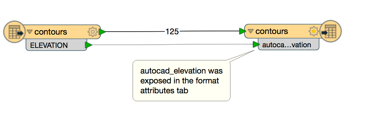
Apparently I made a small mistake in the previous workspace, lines were output as blocks in stead of polylines. I corrected it in this workspace (esrishape2realdwg-v2.fmw) where lines are output. Now I didn't use the 3DForcer, but renamed the attribute ELEVATION to autocad_elevation as was suggested by Dale as well.
+10- March 27, 2018
I still can't get this to work and I've been trying for hours. I have to say customer service is pretty lousy seeing how I can't find any resolution since my original question back in December. I've tried all the suggestions and I still can't get the elevations! When I add the "elevation" attribute it still doesn't appear like the example shown. Very frustrating.
- Author
- March 27, 2018
- Author
- March 27, 2018
I don't AutoCAD allows an object to be 2D and having an elevation value. So no, I do not think 2D output with an elevation value is an option. The only thing you could do is exporting 2D lines and adding a text-element containing the height of the line. That way you'll have 2Ds line and height values as text-elements in a single drawing, but that was not your original question.
Apparently I made a small mistake in the previous workspace, lines were output as blocks in stead of polylines. I corrected it in this workspace (esrishape2realdwg-v2.fmw) where lines are output. Now I didn't use the 3DForcer, but renamed the attribute ELEVATION to autocad_elevation as was suggested by Dale as well.

 +62
+62- Celebrity
- March 27, 2018

Community Stats
- 32,207
- Posts
- 122,303
- Replies
- 39,891
- Members
Latest FME
Enter your E-mail address. We'll send you an e-mail with instructions to reset your password.
Scanning file for viruses.
Sorry, we're still checking this file's contents to make sure it's safe to download. Please try again in a few minutes.
OKThis file cannot be downloaded
Sorry, our virus scanner detected that this file isn't safe to download.
OK