Solved

Move Address Points to closest Parcel edge or curbside of Address?


I'm trying to move address points from essentially rooftoop locations to the curbside of the address automatically (working with about 10,000 points)


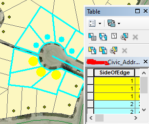
I've got the polygon parcel data, the address point data (contains which side of road the point is located on, but is the only layer I have with this information), and the road polyline.


I thought the best way to set this up would be to move the address points within its containing parcel to the closet edge of the parcel it's contained in. However I think there would be quite a few scenarios where it wouldnt move the point to curbside and so I'm trying to figure out if that is the cleanest approach and how I could set that up, or if theres a better idea.


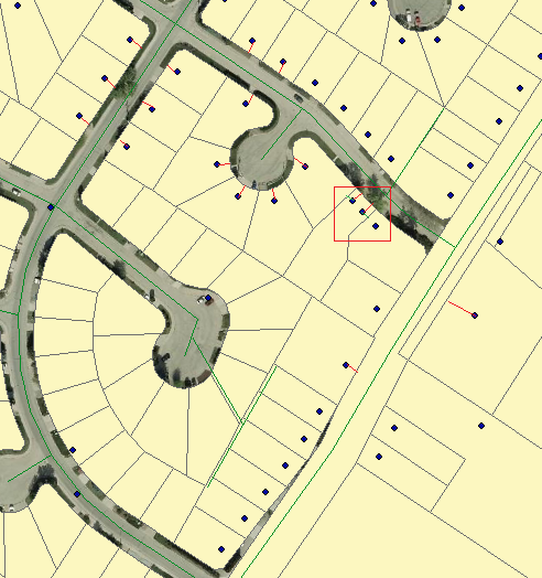
I've added a picture of the layers I'm working with and how I want the points to appear.


Ideally I'd want the points moved to where the end of where I've drawn out the red line would be the ideal goal, however if I were to move points to closest edge of parcel, in the red square outlined area it would probably move it to the end of the green line instead of moving the point closer to curb of the house which is the ultimate goal.

Untitledimage

Best answer by ctredinnick

richard_che wrote:

I can snap the address to that point, but I dont know how to create a point from the polygon that is closest to the street centerline, and I'd want to join on Road name as an added QC. I dont think centerpoint replacer would work for this right?

The NeighborFinder adds attributes of both the base and candidate's nearest X and Y coordinates. So in this case it'll return the nearest point on the parcel geometry to the centreline. Merge those XY's onto the addresses of each parcel, then use a VertexCreator set to ReplaceWithPoint, to 'move' the address to that point.


That might not produce the right result on corner properties, so a better approach might be to draw a line between the address and it's road (nearest neighbour, with a group by on road name), and intersect that line with the parcel boundary. That's assuming the address and road data uses the same road names.

image 


View original
Did this help you find an answer to your question?

6 replies

Forum|alt.badge.img+2

@richard_che​ Could you find the point on the parcel that is closest to the street centreline and then use that as the point for you address?


markatsafe wrote:

@richard_che​ Could you find the point on the parcel that is closest to the street centreline and then use that as the point for you address?

In that scenario would the point get snapped to the street centerline using anchored snapper? I cant have the point moved to the center of the road.


Forum|alt.badge.img+2

@richard_che​ Step 1. Find the point on the parcel that is closest to the street centreline. Step 2. Snap your address to that point.


markatsafe wrote:

@richard_che​ Step 1. Find the point on the parcel that is closest to the street centreline. Step 2. Snap your address to that point.

I can snap the address to that point, but I dont know how to create a point from the polygon that is closest to the street centerline, and I'd want to join on Road name as an added QC. I dont think centerpoint replacer would work for this right?


ctredinnick
Supporter
Forum|alt.badge.img+18
  • Supporter
  • Best Answer
  • May 1, 2022
richard_che wrote:

I can snap the address to that point, but I dont know how to create a point from the polygon that is closest to the street centerline, and I'd want to join on Road name as an added QC. I dont think centerpoint replacer would work for this right?

The NeighborFinder adds attributes of both the base and candidate's nearest X and Y coordinates. So in this case it'll return the nearest point on the parcel geometry to the centreline. Merge those XY's onto the addresses of each parcel, then use a VertexCreator set to ReplaceWithPoint, to 'move' the address to that point.


That might not produce the right result on corner properties, so a better approach might be to draw a line between the address and it's road (nearest neighbour, with a group by on road name), and intersect that line with the parcel boundary. That's assuming the address and road data uses the same road names.

image 


richard_che wrote:

I can snap the address to that point, but I dont know how to create a point from the polygon that is closest to the street centerline, and I'd want to join on Road name as an added QC. I dont think centerpoint replacer would work for this right?

Thank you so much! Going to try that out tomorrow.


Cookie policy

We use cookies to enhance and personalize your experience. If you accept you agree to our full cookie policy. Learn more about our cookies.

 
Cookie settings