Solved

Get a raster of altitudes with a specific interval.


Forum|alt.badge.img

Hello FME-Community,

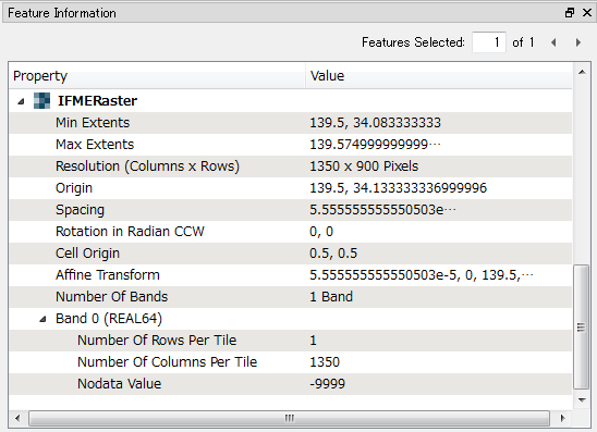
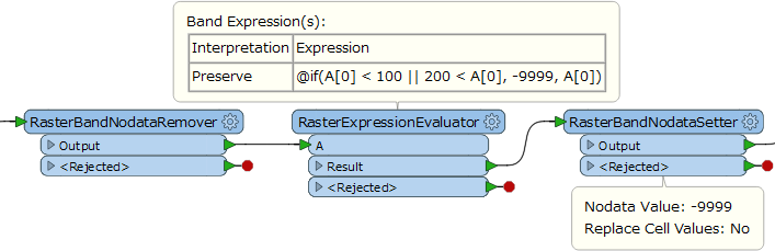
I am working with FME desktop 2017 and with a raster layer of altitudes. I would like to obtain a new raster layer from the previous one, which shows a range of altitudes between 100 and 200 meters.

I am new working with FME and I still have not been able to find a tool to perform this operation. Could you help me or give me an idea?

Thank you very much.


Best answer by takashi

Hi @cesar_vicente, firstly you have to check properties of the source raster, especially the number of bands and whether it has Nodata (and the Nodata value if it exists). You can see the properties with the Feature Information window in FME Data Inspector.

If relevant properties of your raster are the same as the example above (i.e. only has a single band with REAL64 interpretation and Nodata = -9999), this workflow replaces cell values less than 100 or greater than 200 with the Nodata value (-9999 in this case).

View original
Did this help you find an answer to your question?

4 replies

takashi
Contributor
Forum|alt.badge.img+19
  • Contributor
  • Best Answer
  • February 7, 2018

Hi @cesar_vicente, firstly you have to check properties of the source raster, especially the number of bands and whether it has Nodata (and the Nodata value if it exists). You can see the properties with the Feature Information window in FME Data Inspector.

If relevant properties of your raster are the same as the example above (i.e. only has a single band with REAL64 interpretation and Nodata = -9999), this workflow replaces cell values less than 100 or greater than 200 with the Nodata value (-9999 in this case).


Forum|alt.badge.img

@takashi, thank you very much. The process that you have indicated to me is just what I needed. I would like to ask you one last question. Do you know how to convert the raster layer (result of the process that you have indicated me) to a single polygon? I have used the transformer RasterCellCoercer, but I get a high number of polygons. Maybe they could join later ...


If you can help me I would appreciate it.


takashi
Contributor
Forum|alt.badge.img+19
  • Contributor
  • February 8, 2018
cesar_vicente wrote:

@takashi, thank you very much. The process that you have indicated to me is just what I needed. I would like to ask you one last question. Do you know how to convert the raster layer (result of the process that you have indicated me) to a single polygon? I have used the transformer RasterCellCoercer, but I get a high number of polygons. Maybe they could join later ...


If you can help me I would appreciate it.

Probably the RatserExtentsCoercer (Extents Type: Data Extents) might help you.


Forum|alt.badge.img

Thank you very much @takashi. The two answers to my doubts have been excellent!


Cookie policy

We use cookies to enhance and personalize your experience. If you accept you agree to our full cookie policy. Learn more about our cookies.

 
Cookie settings