Solved

No output with Shortest Path


fmenco
Contributor
Forum|alt.badge.img+5

Hi,

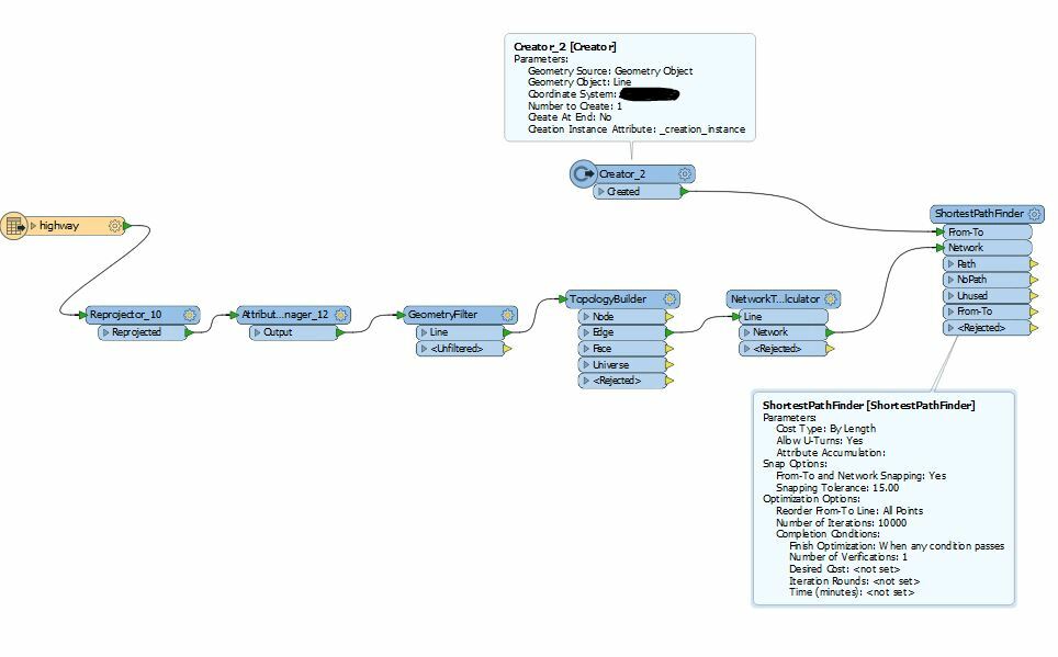
I'm trying to create a shortest path from point A to B, yet FME is not outputting any path. I've looked at similar questions asked on here, and I've adapted my workbench accordinly, but still no luck.

I'm using an OpenStreetMap highway layer as input. I've explicitely set my snapping tolerance as relatively high in the shortespathfinder, just so that I could just get some output. But it didn't work either.

Printscreen of my workbench:


Best answer by david_r

For some reason I've had much better results using a stand-alone Snapper before building the topology, rather than relying on the ShortestPathFinder tolerance.

View original
Did this help you find an answer to your question?

11 replies

takashi
Contributor
Forum|alt.badge.img+19
  • Contributor
  • August 9, 2018

Weren't no features output from the "NoPath" port?

If all network lines don't belong to a single connected network, there could be no path between specified from-to. You can use the NetworkTopologyCalculator to check if the lines belong to a single network.


david_r
Evangelist
  • Best Answer
  • August 9, 2018

For some reason I've had much better results using a stand-alone Snapper before building the topology, rather than relying on the ShortestPathFinder tolerance.


fmenco
Contributor
Forum|alt.badge.img+5
  • Author
  • Contributor
  • August 9, 2018
takashi wrote:

Weren't no features output from the "NoPath" port?

If all network lines don't belong to a single connected network, there could be no path between specified from-to. You can use the NetworkTopologyCalculator to check if the lines belong to a single network.

All the features are output through the unused port. There's also one output though the nopath port, which is just the from-to line. And of course the from-to also outputs the line I created with the creator transformer


fmenco
Contributor
Forum|alt.badge.img+5
  • Author
  • Contributor
  • August 9, 2018
david_r wrote:

For some reason I've had much better results using a stand-alone Snapper before building the topology, rather than relying on the ShortestPathFinder tolerance.

Yes, this worked... Thank you !


owen
Forum|alt.badge.img+1
  • August 9, 2018
Not helpful, but I wouldn't try routing with Open Street Map....


fmenco
Contributor
Forum|alt.badge.img+5
  • Author
  • Contributor
  • August 9, 2018
owen wrote:
Not helpful, but I wouldn't try routing with Open Street Map....


Thanks.... why not? Because of the quality?


owen
Forum|alt.badge.img+1
  • August 9, 2018
fmenco wrote:
Thanks.... why not? Because of the quality?


Yes, its not designed for routing so you might get some odd results


fmelizard
Contributor
Forum|alt.badge.img+17
  • Contributor
  • August 9, 2018
david_r wrote:

For some reason I've had much better results using a stand-alone Snapper before building the topology, rather than relying on the ShortestPathFinder tolerance.

@david_r Snapping within the ShortestPathFinder is only for snapping "points of the From-To line to the closest end points of the Network lines". Snapping From-To points to segments isn't possible yet and the ShortestPathFinder needs a clean network for input.


fmenco
Contributor
Forum|alt.badge.img+5
  • Author
  • Contributor
  • August 10, 2018
fmelizard wrote:
@david_r Snapping within the ShortestPathFinder is only for snapping "points of the From-To line to the closest end points of the Network lines". Snapping From-To points to segments isn't possible yet and the ShortestPathFinder needs a clean network for input.


Thank you!


And how would this whole "shortest path finder" process with the same parameters (by lenght, by costs etc) be accomplished with raster data?


@takashi


@david_r


@owen


@DanAtSafe


david_r
Evangelist
  • August 10, 2018
fmelizard wrote:
@david_r Snapping within the ShortestPathFinder is only for snapping "points of the From-To line to the closest end points of the Network lines". Snapping From-To points to segments isn't possible yet and the ShortestPathFinder needs a clean network for input.


Thanks for clarifying, I should've had another coffee before before writing that answer :-)

fmelizard
Contributor
Forum|alt.badge.img+17
  • Contributor
  • August 10, 2018
fmenco wrote:
Thank you!


And how would this whole "shortest path finder" process with the same parameters (by lenght, by costs etc) be accomplished with raster data?


@takashi


@david_r


@owen


@DanAtSafe


@fmenco You'd have to convert the raster data to vector first - the ShortestPathFinder only accepts line features.


Reply


Cookie policy

We use cookies to enhance and personalize your experience. If you accept you agree to our full cookie policy. Learn more about our cookies.

 
Cookie settings