Question

georeferencing PDF


Hello,

I'm trying to georeference some non-geospatial PDF files. I have the corresponding GEOTIFF and a shape of the desired bound for each one. I need a PDF output in CMYK and a reasonable file size (that's why i'm not using GEOTIFF directly in the first place).

Here is what I have tried so far:

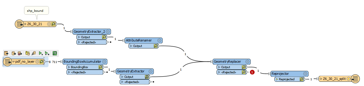
1) replace the boundingbox geometry of the pdf by the shape, but the pdf bondingbox get rejected

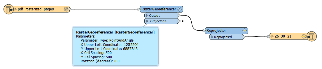
2) use raster georeferencer with known upper left coodinates, but I don't know how to find the appropriate cell spacing, and using raster is part of my problem (as explained above).

Any ideas ? Thanks

3 replies

virtualcitymatt
Celebrity
Forum|alt.badge.img+35

The cell spacing should be used from the raster data itself - check in the data inspector for the cell spacing. If you are worried thay the file will be too big you can use a RasterResampler to reduce the resolution of the original.

As a side not the Geotiff writer has the ability to compress if you want to use the GeoTIff. You can use JPEG compression and set it fairly high - I think 75% is the default.


  • Author
  • January 30, 2020
virtualcitymatt wrote:

The cell spacing should be used from the raster data itself - check in the data inspector for the cell spacing. If you are worried thay the file will be too big you can use a RasterResampler to reduce the resolution of the original.

As a side not the Geotiff writer has the ability to compress if you want to use the GeoTIff. You can use JPEG compression and set it fairly high - I think 75% is the default.

Hi, thank you for your response, i used the raster propertyextractor on my geotiff but the cell spacing is way too small and somehow fme upper_left_x and upper_left_y aren't exactly the same as indicated in the .tfw file


redgeographics
Celebrity
Forum|alt.badge.img+49
sandry wrote:

Hi, thank you for your response, i used the raster propertyextractor on my geotiff but the cell spacing is way too small and somehow fme upper_left_x and upper_left_y aren't exactly the same as indicated in the .tfw file

In the TFW the upper left x and y coordinates are for the center of the upper left pixel, so they can be off from the bounds extracted earlier.


Reply


Cookie policy

We use cookies to enhance and personalize your experience. If you accept you agree to our full cookie policy. Learn more about our cookies.

 
Cookie settings