Question

Projecting an unreferenced NetCDF


johnk
Contributor
Forum|alt.badge.img+4
  • Contributor

Hi FME world,

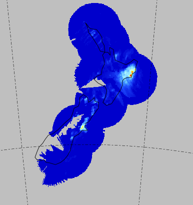
I have received a series of NetCDF files (representing rain radar) and I have no information on the projection for them, other than they are supposed to be in New Zealand and maybe Lambert Conformal? I can represent in an app like Panoply (image below) but when I try to project in FME, NZTM or LL84 is incorrect. I have tried creating a custom coordinate system but this is no use either. 
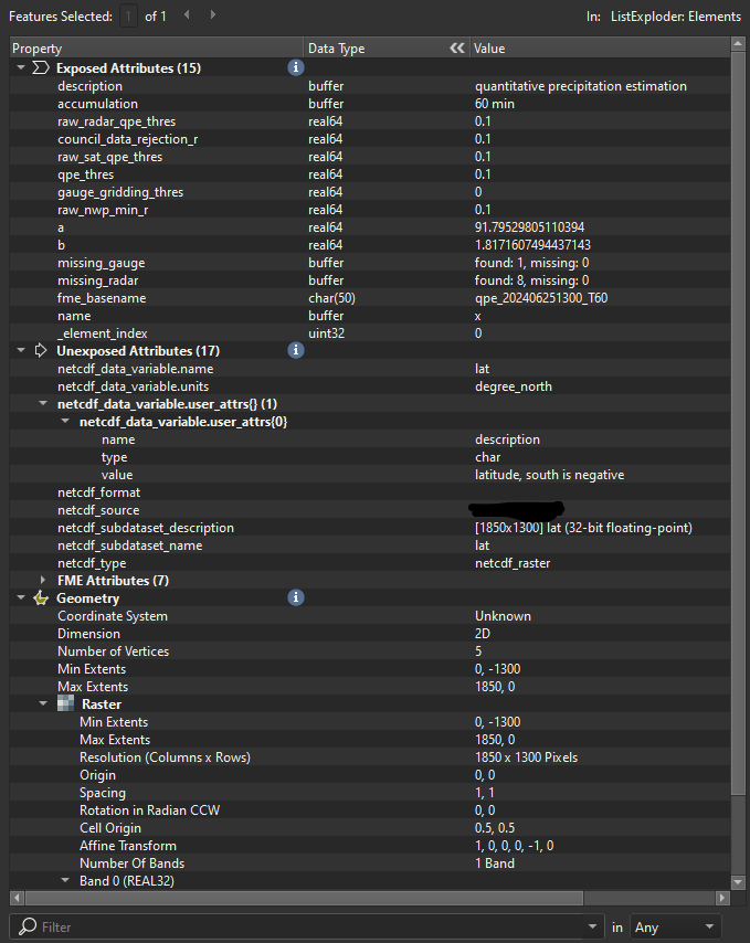
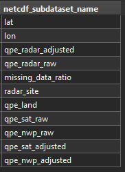
I’ve included a view of the Feature Information with the exposed list as per this conversation NetCDF - no CRS desposited | Community.

Would love some direction if anyone has any thoughts?! Thanks! 


4 replies

david_r
Evangelist
  • March 6, 2025

The challenge with Netcdf is that it’s a very feature-rich, but also a very open format. This is why there are initiatives for standardizing how to structure the contents, such as the CF conventions. But these are optional.

I often find that the best way to get a full overview of a particular Netcdf file is to use the ncdump command line utility to dump the Netcdf header contents as text and inspecting the resulting dump. The reason is that there are possible constructs in the Netcdf header that aren’t always made visible in FME, e.g. grid mappings that can be used to map x/y cells to one or several geographic coordinate systems.

Failing that, I’m not sure you have many other options than either guessing or contacting the data source.


redgeographics
Celebrity
Forum|alt.badge.img+49

Given that it is New Zealand and you say it might be Lambert, I’d suggest trying the New Zealand Continental Shelf Lambert projection, EPSG:17964. Unfortunately it’s not supported in the Reprojector or ProjReprojector, so you would have to set up a manual transformation in the ProjReprojector


david_r
Evangelist
  • March 6, 2025

In my own experience, Netcdfs should (ideally ;-) contain the ground coordinates for each cell, but the way they do it can vary. If you manually reproject the raster, there’s a chance that you’ll deform the raster or introduce artefacts or weirdness at the boundaries. Depending on your use case, the consequence of this can vary from “I don’t care” to “the data is now unusable” and everything in between.

Therefore my recommendation would be to first check the “ncdump” for ground coordinates before going that route.


johnk
Contributor
Forum|alt.badge.img+4
  • Author
  • Contributor
  • March 6, 2025
david_r wrote:

In my own experience, Netcdfs should (ideally ;-) contain the ground coordinates for each cell, but the way they do it can vary. If you manually reproject the raster, there’s a chance that you’ll deform the raster or introduce artefacts or weirdness at the boundaries. Depending on your use case, the consequence of this can vary from “I don’t care” to “the data is now unusable” and everything in between.

Therefore my recommendation would be to first check the “ncdump” for ground coordinates before going that route.

Thanks for the replies!
So each NetCDF file has a few features, of which ‘lat’ and ‘lon’ are present, plus the actual radar value i need ‘qpe_radar_adjusted’. See below. So i can combine these into a single raster to get 3 bands (lat, lon and qpe) - but when i try to project into lat/lon (as the name suggests) - its still being funky!


Cookie policy

We use cookies to enhance and personalize your experience. If you accept you agree to our full cookie policy. Learn more about our cookies.

 
Cookie settings