Question
Workflow help: Mapping Microstation level names to file geodatabase
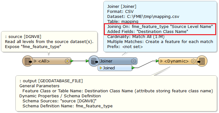
I have two main drafting workspaces in Microstation; Civil and Survey. Each workspace has a specific set of levels that it uses. I need to map these levels to existing feature classes in a ESRI file geodatabase. There will be many reader files, but all will use the same level names. For example, design file XX01.dgn comes in and I set up a workspace to translate level names to the appropriate feature classes. Then design file XX02.dgn comes in and want to use the same workspace to translate the levels contained in XX02.dgn (which all have the same names as the levels in XX01.dgn) without having to connect each level name to the feature classes again. The drafting workspaces contain several hundreds of levels and I've already created test FME workspaces for Civil and Survey features to make sure all level translate correctly. Is there any way to format an FME workspace such that for any reader/design file, map these level names to these feature classes using these transformers?
This post is closed to further activity.
It may be an old question, an answered question, an implemented idea, or a notification-only post.
Please check post dates before relying on any information in a question or answer.
For follow-up or related questions, please post a new question or idea.
If there is a genuine update to be made, please contact us and request that the post is reopened.