Hi everybody I desperately need some help!! Here is my problem... So far I've been able to generate a bunch of different networks from my water pipes. I've also been able to use a fanout to extract them all to multiple PDF files, based on their network ID. Now, I'm simply trying to add some PNG images (North arrow, logo, etc.) on each PDF files, without any success?! At this point I've tried many things, but I'm now running out of ideas...

As suggested on another thread (https://knowledge.safe.com/questions/2403/adding-a-logo-to-a-pdf-when-using-fanout.html) I was under the impression that by using a Cloner to get as many images as I had networks, then by using the PDFPageFormater to add the images to each PDF files or a RasterGeoreferencer to specify where I want the images to be located on the page, I would be able to achieve that but I couldn't figure out how... And speaking of the RasterGeoreferencer, I didn't find out how to use page units instead of real coordinates, is it even possible?!

Please, tell me that there is a nice and easy way to achieve that with FME! 🙂 Thanks in advance for your time!!

Hi,

This old article might be helpful on how to place certain elements into a PDF .

Hope this helps.

https://knowledge.safe.com/articles/19757/creating-pdf-cartographic-output.html


Have you resolved your issue yet? I have the same problem. I found a newer article and I'm going to try this newer one on my workspace: https://community.safe.com/s/article/creating-pdf-cartographic-output


I seem to recall there being an issue with using transparent png's in PDF. Can you try with jpg's instead, see if that makes a difference?


transparency is not supported by writer, as it uses a jpeg2000 isfai understand .

Cloning objects to as many pages is correct.

But you need to use the counter as pagenumber. SO you must set pdf_page_number (for multipage pdf) on the obejcts that need to be on the same page.

else fan-out on layer name

For instance using a cloner and the a featuremerger.

Page units can be calculated. Extract bounding box (or rasterextent) and calculate (1inch/72points) to get worldframe size.


Hi,

This old article might be helpful on how to place certain elements into a PDF .

Hope this helps.

https://knowledge.safe.com/articles/19757/creating-pdf-cartographic-output.html

Hi Itay, thanks for the info, I've initially created my workbench after reading this very useful article! But unfortunately it didn't help me resolving that problem...


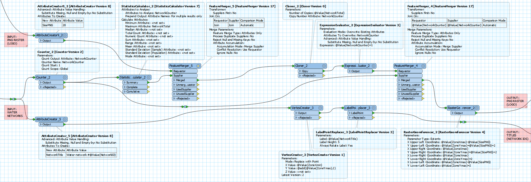
@geospatiallover after countless attempts, I finally managed to generate these PDF... As @gio suggested, I used a cloner to add a title and an image to all my PDF:

Give it a try, and let me know if you have questions/problems with this...

Cheers!


Reply