Solved

Need easy way of calculating/exporting min/max width of polygon


Did this help you find an answer to your question?
Show first post

29 replies

davideagle
Contributor
Forum|alt.badge.img+21
  • Contributor
  • January 18, 2016
takashi wrote:

Unfortunately I also don't know how you can use the ArcGIS Python function in FME workspace.

I upgraded my previous solution. The attached workspace is not perfect, but generates "better" cross sections for some areas as shown in this image. estimate-river-cross-sections.zip
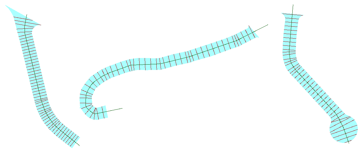
The key point is how to create "clean" center line for the river area, and the Generalizer might be useful in this case. However, the best solution could be different depending on the actual data condition. As @rollo mentioned at first, I think you cannot avoid doing trial and error approach to find appropriate solutions for each area. Good luck!

Excellent work


takashi
Contributor
Forum|alt.badge.img+22
  • Contributor
  • January 18, 2016
takashi wrote:

Unfortunately I also don't know how you can use the ArcGIS Python function in FME workspace.

I upgraded my previous solution. The attached workspace is not perfect, but generates "better" cross sections for some areas as shown in this image. estimate-river-cross-sections.zip

The key point is how to create "clean" center line for the river area, and the Generalizer might be useful in this case. However, the best solution could be different depending on the actual data condition. As @rollo mentioned at first, I think you cannot avoid doing trial and error approach to find appropriate solutions for each area. Good luck!

Extension. I published a custom transformer named BoundsSplitter in the FME Store. It implements the algorithm similar to the ArcGIS python function ;)


Forum|alt.badge.img
  • Author
  • January 19, 2016
takashi wrote:

Unfortunately I also don't know how you can use the ArcGIS Python function in FME workspace.

I upgraded my previous solution. The attached workspace is not perfect, but generates "better" cross sections for some areas as shown in this image. estimate-river-cross-sections.zip

The key point is how to create "clean" center line for the river area, and the Generalizer might be useful in this case. However, the best solution could be different depending on the actual data condition. As @rollo mentioned at first, I think you cannot avoid doing trial and error approach to find appropriate solutions for each area. Good luck!

Yes, thank you for the best FME solution to this problem. I appreciate all your efforts. Hopefully I can buy you a non-trivial beverage some day.

Best,

Pete


Forum|alt.badge.img
  • October 18, 2019
takashi wrote:

Unfortunately I also don't know how you can use the ArcGIS Python function in FME workspace.

I upgraded my previous solution. The attached workspace is not perfect, but generates "better" cross sections for some areas as shown in this image. estimate-river-cross-sections.zip

The key point is how to create "clean" center line for the river area, and the Generalizer might be useful in this case. However, the best solution could be different depending on the actual data condition. As @rollo mentioned at first, I think you cannot avoid doing trial and error approach to find appropriate solutions for each area. Good luck!

Many thanks for this Takashi - I managed to adapt the workspace for us to calculate minimum widths of our roadside nature reserves - invaluable!

Best wishes,

Jane


Reply


Cookie policy

We use cookies to enhance and personalize your experience. If you accept you agree to our full cookie policy. Learn more about our cookies.

 
Cookie settings