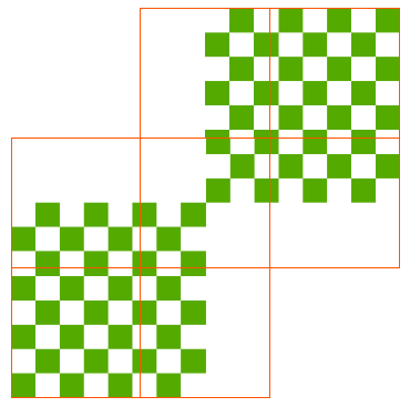
I want to cut a raster with shp file, and the result raster will have the extent of the clipper's instead of the clippee's. (consider null or nodata as filled up)
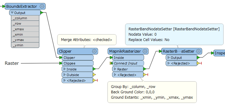
This post is closed to further activity.
It may be an old question, an answered question, an implemented idea, or a notification-only post.
Please check post dates before relying on any information in a question or answer.
For follow-up or related questions, please post a new question or idea.
If there is a genuine update to be made, please contact us and request that the post is reopened.
Not sure I fully understand, but is it perhaps the RasterTiler that you are looking for?
no, not raster tiler.
When I clip a raster with shp polygon, I want the raster will take the polygon extend if there are places the raster it was not covered, then the result can be filled up with 0.
Use the clipper, make sure Preserve Clippee Extents is set to No. You can explicitly set the NoData value before hand by using the RasterBandNoDataSetter, if you don't it defaults to 0
yes! Each read polygon is a tiled raster. So it will end up in 7 small rasters with same extents and same resolution.
If the number of tiles is very large, it might be better to sort the clipped rasters by column and row indices and set 'Yes' to the 'Input is Ordered by Group' parameter in the MapnikRasterizer.
I want to clip a raster (MDT=1 band) -generated from 2 asc files (no problem)- to many tif tiles following exact coordinates extracted from a shapefile. If tiles are smaller than the extend of shape, they should be filled with any value but the tfw of tiles should be exactly the same the coordinate of the clipper (shape).
When I appy Clipper tranformer, the coordinates are not exactly the same of the shape. When I add also Mapnik Rasterizer, the results are tiles on coordinates ok following the shape, but they are RGB type and no data values in all the tiles (empty tiles). In attachment the model. thanks
I have a similar problem but I havent solved it yet.
I have a raster 1 band extracted from asc files (no problem). I want to tile it in different tiles following coordinates extended of a shapefile. If the tiles dont cover the shape extend they should be filled with any value but the coordinates should be the same than the shapefile (clipper).
If I apply only Clipper tranformer the tiles are ok but the coordinates extend dont follow the shape extend because the tiles are smaller and dont fill the no data.
If I also add Mapnik rasterizer the coordinates of tiles are ok but the tiles are RGB and empty.
What are the Mapnik rasterizer parameteres I should consider? Thanks, mapnik.jpg
The MapnikRasterizer generate RGB or RGBA image raster, so it's hard to apply to your case - i.e. handling 1 band Numeric raster. Please see my solution attached in the previous comment.
Many thanks for your reply but I can´t achieve the results expected. In attachment my data to be used. The results should be 8 tiles with the same extension than the shape (results.jpg)