Solved

Reverse OpenCage Geocoder doesn't create polygons


Forum|alt.badge.img

Hi,

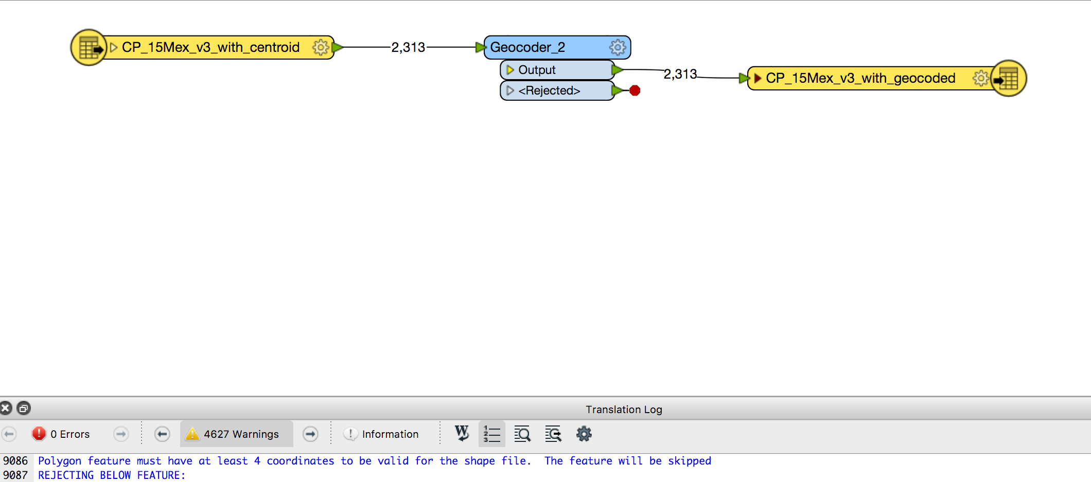
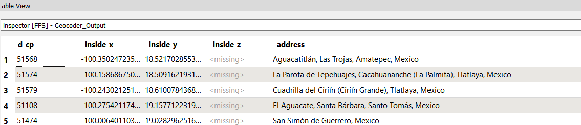
I am using the Geocoder for the first time and I get lot of warnings that feature must have at least 4 coordinates and then my output file has no coordinates.

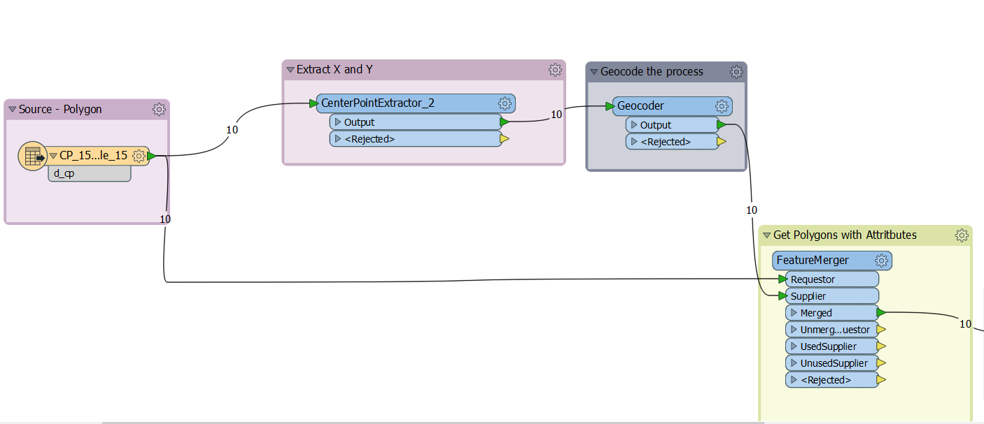
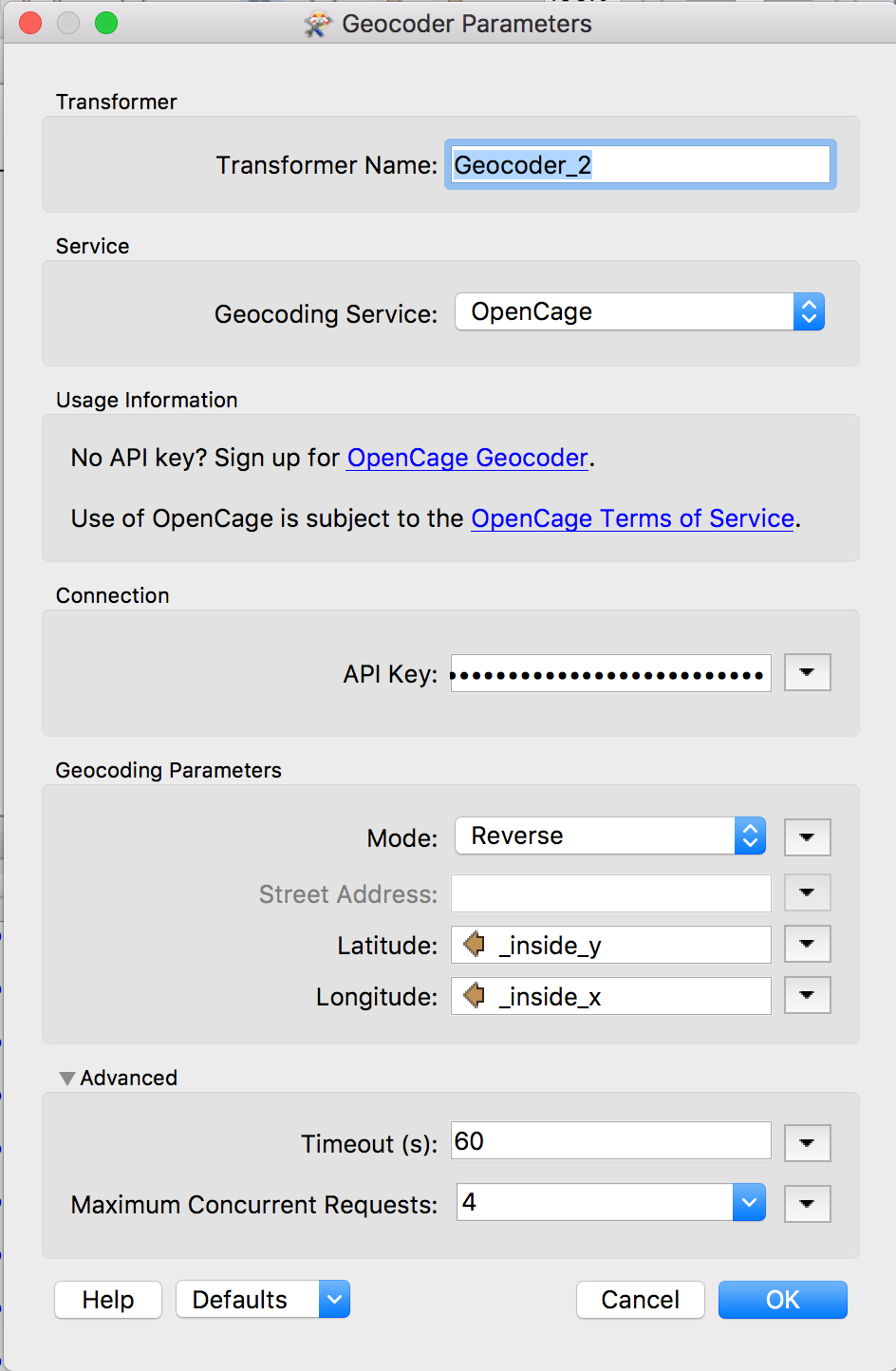
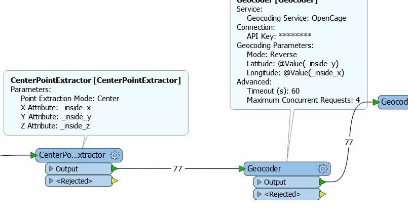
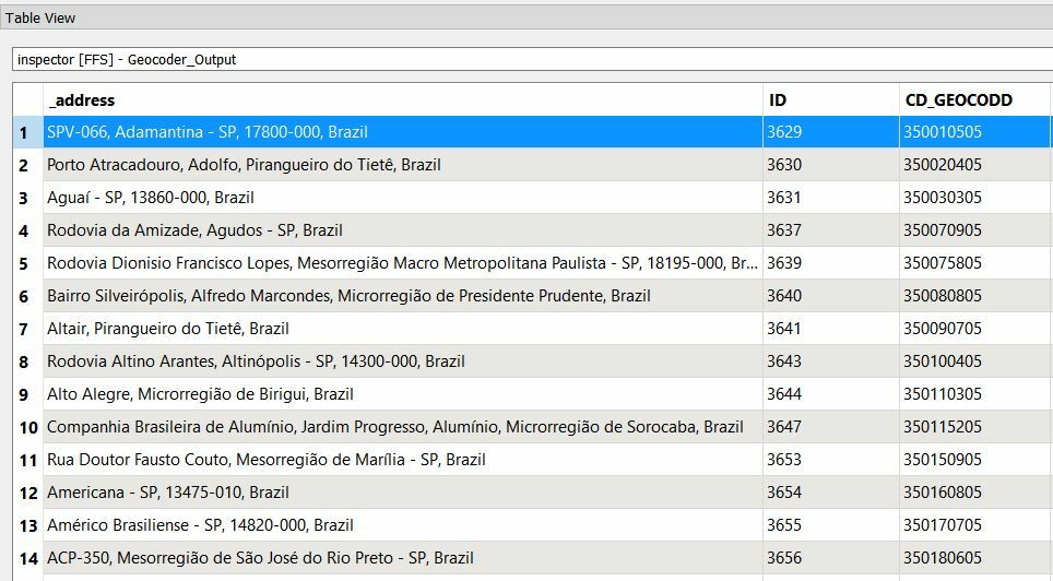
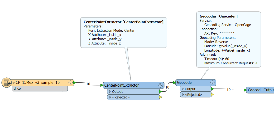
I start with a shp file that has postal codes and centroid for each of the postal code and then I am doing reverse look up using the OpenCage API. I set up inside x and y as my Lat and long and and entered my API Key. Those are the only set ups I did in the Transformer.

Am I missing something? Can someone please help me?

Best answer by danilo_fme

Hi @jitkam,

Please, see the image below:

You can use the Workspace that I created - workspace-geocoder.fmwt

Thanks,

Danilo

View original
Did this help you find an answer to your question?

19 replies

danilo_fme
Evangelist
Forum|alt.badge.img+45
  • Evangelist
  • April 17, 2018

Hi @jitkam,

Could you share us a picture or your Workspace to understand better the configurations that you did?

Thanks,

Danilo


Forum|alt.badge.img
  • Author
  • April 17, 2018

Geocoder settings


Forum|alt.badge.img
  • Author
  • April 17, 2018

Workspace with the warnings sample

Forum|alt.badge.img
  • Author
  • April 17, 2018
danilo_fme wrote:

Hi @jitkam,

Could you share us a picture or your Workspace to understand better the configurations that you did?

Thanks,

Danilo


Hi Danilo, just did


Thx


Jitka

danilo_fme
Evangelist
Forum|alt.badge.img+45
  • Evangelist
  • April 17, 2018
jitkam wrote:


Hi Danilo, just did


Thx


Jitka
Thanks @jitkam


I created here a Workspace: Read polygons from Shapefile -> Transformer CenterPointExtractor -> Geocoder .


Results in FME Data Inspector:


Thanks,


Danilo


Forum|alt.badge.img
  • Author
  • April 17, 2018

@danilo,

I have the same Geocoder settings. Do you think the problem is with my source file?


danilo_fme
Evangelist
Forum|alt.badge.img+45
  • Evangelist
  • April 17, 2018
jitkam wrote:

@danilo,

I have the same Geocoder settings. Do you think the problem is with my source file?

@jitkam


Cloud you send me some polygons to test?


Forum|alt.badge.img
  • Author
  • April 18, 2018

@danilo_fme, here is the sample

Thank you

Jitka

archive.zip


Forum|alt.badge.img
  • Author
  • April 18, 2018

@danilo_fme

here is the sample,

thank you

Jitka

archive.zip


danilo_fme
Evangelist
Forum|alt.badge.img+45
  • Evangelist
  • April 18, 2018
jitkam wrote:

@danilo_fme

here is the sample,

thank you

Jitka

archive.zip

Hi @jitkam


Thanks your source data. I used it in my Workspace - reading the shape file.


After the transformer CenterPointExtractor was used to extract the coordinates X and Y.


And the results was returned after the geocode process:


Your Writer is a point geometry, correct?


Thanks,


Danilo


Forum|alt.badge.img
  • Author
  • April 18, 2018
danilo_fme wrote:
Hi @jitkam


Thanks your source data. I used it in my Workspace - reading the shape file.


After the transformer CenterPointExtractor was used to extract the coordinates X and Y.


And the results was returned after the geocode process:


Your Writer is a point geometry, correct?


Thanks,


Danilo


Hi Danilo,


actually, should be polygons. I did exact the same setting as you show above and used the sample I sent you and still I get the errors and no output file.


danilo_fme
Evangelist
Forum|alt.badge.img+45
  • Evangelist
  • April 19, 2018
jitkam wrote:
Hi Danilo,


actually, should be polygons. I did exact the same setting as you show above and used the sample I sent you and still I get the errors and no output file.


Its possible that your writer file is set like polygon geometry. Could you share your Writer file? I believe you are try to write point in polygon Writer.


danilo_fme
Evangelist
Forum|alt.badge.img+45
  • Evangelist
  • April 19, 2018

Hi @jitkam,

Did you change the format of geometry in your Writer?

Thanks,

Danilo


Forum|alt.badge.img
  • Author
  • April 19, 2018
danilo_fme wrote:
Its possible that your writer file is set like polygon geometry. Could you share your Writer file? I believe you are try to write point in polygon Writer.


Hi @danilo_fme I've uploaded the output file and screenshot of my settings.


I was originally using FME2018, but now tried in 2017, having the same problem.


Thx!


archive-2.zip


screen-shot-2018-04-19-at-111605-am.png


Forum|alt.badge.img
  • Author
  • April 19, 2018
danilo_fme wrote:
Its possible that your writer file is set like polygon geometry. Could you share your Writer file? I believe you are try to write point in polygon Writer.


This is one of the messages I receive in warning.


p, li { white-space: pre-wrap; } Polygon feature must have at least 4 coordinates...rejecting


REJECTING BELOW FEATURE:


+++++++++++++++++++++++++++++++++++++++++++++++++++++++++++++++++++++++++++


Feature Type: `CP_15Mex_v3_sample_15_2017'


Attribute(encoded: utf-8) : `_address' has value `Emilio Portes Gil, San Felipe del Progreso, Mexico'


Attribute(64 bit real) : `_inside_x' has value `-99.919066897024351'


Attribute(64 bit real) : `_inside_y' has value `19.646801735532826'


Attribute(64 bit real) : `_latitude' has value `19.6449664'


Attribute(64 bit real) : `_longitude' has value `-99.9192053'


Attribute(encoded: utf-8) : `d_cp' has value `50680'


Attribute(string) : `fme_feature_type' has value `CP_15Mex_v3_sample_15'


Attribute(string) : `fme_geometry' has value `fme_point'


Attribute(entangled: string): `fme_type' has value `fme_point'


entangled to [SHAPE_GEOMETRY]


Attribute(string) : `multi_writer_id' has value `0'


Coordinate System: `LL84'


Geometry Type: IFMEPoint


Coordinate Dimension: 2


(-99.9192053,19.6449664)


danilo_fme
Evangelist
Forum|alt.badge.img+45
  • Evangelist
  • April 19, 2018

Hi @jitkam,


I solved you problem now using a transformer FeatureMerger.

This transformer is responsible to merger informations between points geometry ( results from transformer Geocoder ) and Polygons ( source data ) respecting a unique attribute d_cp.

Your Writer is a polygon geometry with all attributes.

Attached the Workspace - workspace-geocoder.fmwt

Thanks,

Danilo


Forum|alt.badge.img
  • Author
  • April 19, 2018
danilo_fme wrote:

Hi @jitkam,


I solved you problem now using a transformer FeatureMerger.

This transformer is responsible to merger informations between points geometry ( results from transformer Geocoder ) and Polygons ( source data ) respecting a unique attribute d_cp.

Your Writer is a polygon geometry with all attributes.

Attached the Workspace - workspace-geocoder.fmwt

Thanks,

Danilo


Thank you @danilo_fme,


does the FeatureMerger also needs Supplier? Should I use the Geocoder as such?


Thx


Jitka

danilo_fme
Evangelist
Forum|alt.badge.img+45
  • Evangelist
  • Best Answer
  • April 20, 2018

Hi @jitkam,

Please, see the image below:

You can use the Workspace that I created - workspace-geocoder.fmwt

Thanks,

Danilo


Forum|alt.badge.img
  • Author
  • April 23, 2018
danilo_fme wrote:

Hi @jitkam,

Please, see the image below:

You can use the Workspace that I created - workspace-geocoder.fmwt

Thanks,

Danilo

Thank you @danilo_fme,


it works!!!


Cookie policy

We use cookies to enhance and personalize your experience. If you accept you agree to our full cookie policy. Learn more about our cookies.

 
Cookie settings