Question

Auto-populate fields based on spatial connectivity


Hi FME-ers,


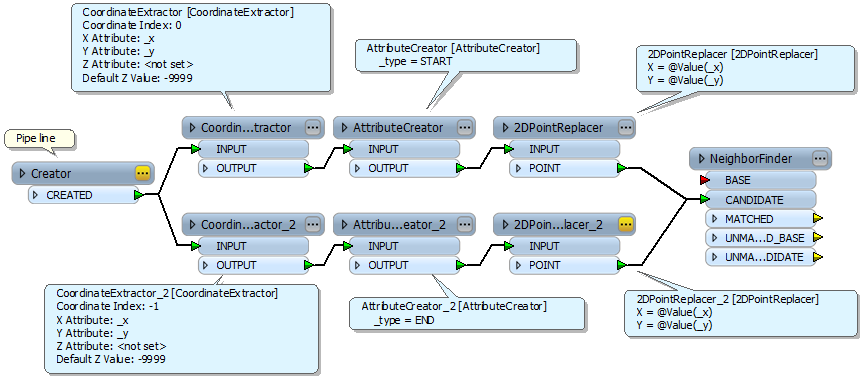
With Desktop 2013, is anyone familiar with a workflow I can use within FME to populate two attribute fields (in a stormwater pipes layer), with corresponding IDs from a connected stormwater pits layer which is snapped to the start and end of each pipe.


The pipe layer is digitised in direction of flow so I would be looking to populate the corresponding upstream and downstream pit attributes to reflect this.


Note: ESRI used to have a VB Script which did this but it is no longer supported in 10.1.


thanks!!!

4 replies

sigtill
Contributor
Forum|alt.badge.img+24
  • Contributor
  • March 12, 2013
Hi whitehorse!


Perhaps you can use the topologybuilder on the lines to "combine" all pipes within the same river - network. And then use a SpatialRelator (TOUCHES, OVERLAPS?) between this network and your pits (areas, I assume?) to get the  relations that are needed. You could then extract the values from the _related_candidates{} - table.

david_r
Evangelist
  • March 12, 2013
Hi,


also look at the NetworkTopologyCalculator.


If it doesn't work with your requirements and your network is already topologically correct, here is one way to do it in a more controlled way:


The key here is to create a point feature for both the start and end points of each line object, then match them spatially to each other with the NeighborFinder (thus all features as CANDIDATE).


You can then use list specified in the "Close candidate list name" of the NeighborFinder to make sure that you only match START points with END points (to preserve direction of flow), etc.


Hope this helps.


David

thanks for your reponses folks. unfortunately, I haven't had a chance to play with the data over the last few weeks because of competing priorities, hence the timelag in responding!


hopefully I will get a chance to look at it soon.


thanks again.

blueinc
Contributor
Forum|alt.badge.img+6
  • Contributor
  • January 6, 2015
Once you match the START points with the END points, how would you add a 'line order' to the original Lines, based on the sequence of lines? 


TIA


B

Cookie policy

We use cookies to enhance and personalize your experience. If you accept you agree to our full cookie policy. Learn more about our cookies.

 
Cookie settings