Question

How to calculate length of polyline in metres when dataset is Lat Long?

  • November 15, 2024
  • 3 replies
  • 43 views

nicholas
Contributor
Forum|alt.badge.img+11

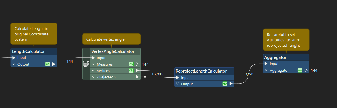
I have a dataset, representing a road network, in a Geographic Lat/Long coordinate reference system. The area covers three UTM zones.

I want to calculate the length of roads / polylines with metres as the unit of measurement.

What transformer should I use?

3 replies

cosminciotina
Contributor
Forum|alt.badge.img+3

Hello. You could use ReprojectLenghtCalculator.
Also, I think you need to calculate the length in the original coordinate system, also the angle of vertex. Then use ReprojectLenghtCalculator and Aggregator and be careful to set the reprojected length field as Attribute to sum.  


hkingsbury
Celebrity
Forum|alt.badge.img+53
  • Celebrity
  • November 17, 2024
cosminciotina wrote:

Hello. You could use ReprojectLenghtCalculator.
Also, I think you need to calculate the length in the original coordinate system, also the angle of vertex. Then use ReprojectLenghtCalculator and Aggregator and be careful to set the reprojected length field as Attribute to sum.  


I don’t think that approach will give you the expected results as you’re calculating the final length as the sum of the distance of each vertex angle using the original distance from the line. In other words, if the line has 5 vertices, you’re calculating the distance 5 times for each vertex then summing them together; effectively giving you a calculated distance 5x the actually distance.

I think you’ll probably have to clip the road network to the utm zones, then re-project into the appropriate zone, calculate the length, aggregate/sum roads that go over multiple zones, then you can merge the distance back onto your LL dataset


nielsgerrits
VIP
Forum|alt.badge.img+54
hkingsbury wrote:
cosminciotina wrote:


I think you’ll probably have to clip the road network to the utm zones, then re-project into the appropriate zone, calculate the length, aggregate/sum roads that go over multiple zones, then you can merge the distance back onto your LL dataset

Have not tried this but I was thinking in the same directions.


Cookie policy

We use cookies to enhance and personalize your experience. If you accept you agree to our full cookie policy. Learn more about our cookies.

 
Cookie settings