Question

gml:MultiSurface to WKT Multipolygon


Hi all,


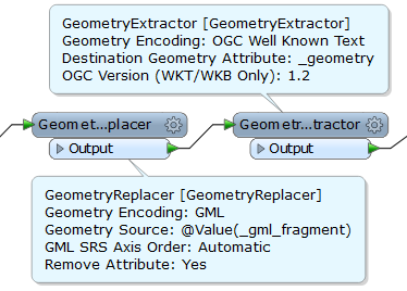
I have a GML geometry that I would like to convert to WKT (in order to insert it in the geometry with Z column of a PostGIS DB). Here is a geometry sample (from CityGML):


 <gml:MultiSurface srsName="EPSG:4979" srsDimension="3">                     <gml:surfaceMember srsDimension="3">                         <gml:Polygon srsDimension="3">                             <gml:exterior>                                 <gml:LinearRing srsDimension="3">                                     <gml:posList srsDimension="3">41.8636830995329 12.4911723999943 0 41.8637580995329 12.4912074999943 0 41.8637078995329 12.4914008999944 0 41.8636328995329 12.4913657999944 0 41.8636830995329 12.4911723999943 0</gml:posList>                                 </gml:LinearRing>                             </gml:exterior>                         </gml:Polygon>                     </gml:surfaceMember>                     <gml:surfaceMember srsDimension="3">                         <gml:Polygon srsDimension="3">                             <gml:exterior>                                 <gml:LinearRing srsDimension="3">                                     <gml:posList srsDimension="3">41.8637580995329 12.4912074999943 0 41.8636830995329 12.4911723999943 0 41.8636830995329 12.4911723999943 13 41.8637580995329 12.4912074999943 13 41.8637580995329 12.4912074999943 0</gml:posList>                                 </gml:LinearRing>                             </gml:exterior>                         </gml:Polygon>                     </gml:surfaceMember>                     <gml:surfaceMember srsDimension="3">                         <gml:Polygon srsDimension="3">                             <gml:exterior>                                 <gml:LinearRing srsDimension="3">                                     <gml:posList srsDimension="3">41.8637078995329 12.4914008999944 0 41.8637580995329 12.4912074999943 0 41.8637580995329 12.4912074999943 13 41.8637078995329 12.4914008999944 13 41.8637078995329 12.4914008999944 0</gml:posList>                                 </gml:LinearRing>                             </gml:exterior>                         </gml:Polygon>                     </gml:surfaceMember>           [...]           </gml:MultiSurface>
 So, the <gml:MultiSurface> contains several <gml:surfaceMember>, each of them being a <gml:Polygon>. I would like to convert this geometry to a WKT Multipolygon representation. If I use a GeometryExtractor, my input GML geometry is output like this and cannot be inserted into the PostGIS table:


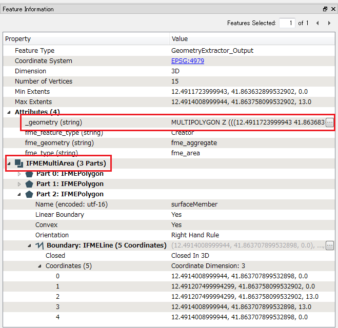
 MULTIPOLYGON ((12.4889684999943 41.8608646995328 0,12.4892365999943 41.8608671995328 0),(12.4892365999943 41.8608671995328 0,12.4892352999943 41.8608493995329 0),(12.4892352999943 41.8608493995329 0,12.4893177999943 41.8608503995328 0),(12.4893177999943 41.8608503995328 0,12.4893234999943 41.8606906995328 0),(12.4893234999943 41.8606906995328 0,12.4889687999943 41.8606866995328 0),(12.4889687999943 41.8606866995328 0,12.4889684999943 41.8608646995328 0)),MULTIPOLYGON ((12.4892365999943 41.8608671995328 0,12.4889684999943 41.8608646995328 0),(12.4889684999943 41.8608646995328 0,12.4889684999943 41.8608646995328 9),(12.4889684999943 41.8608646995328 9,12.4892365999943 41.8608671995328 9),(12.4892365999943 41.8608671995328 9,12.4892365999943 41.8608671995328 0)),MULTIPOLYGON ((12.4892352999943 41.8608493995329 0,12.4892365999943 41.8608671995328 0),(12.4892365999943 41.8608671995328 0,12.4892365999943 41.8608671995328 9),(12.4892365999943 41.8608671995328 9,12.4892352999943 41.8608493995329 9),(12.4892352999943 41.8608493995329 9,12.4892352999943 41.8608493995329 0)),MULTIPOLYGON ((12.4893177999943 41.8608503995328 0,12.4892352999943 41.8608493995329 0),(12.4892352999943 41.8608493995329 0,12.4892352999943 41.8608493995329 9),(12.4892352999943 41.8608493995329 9,12.4893177999943 41.8608503995328 9),(12.4893177999943 41.8608503995328 9,12.4893177999943 41.8608503995328 0)),MULTIPOLYGON ((12.4893234999943 41.8606906995328 0,12.4893177999943 41.8608503995328 0),(12.4893177999943 41.8608503995328 0,12.4893177999943 41.8608503995328 9),(12.4893177999943 41.8608503995328 9,12.4893234999943 41.8606906995328 9),(12.4893234999943 41.8606906995328 9,12.4893234999943 41.8606906995328 0)),MULTIPOLYGON ((12.4889687999943 41.8606866995328 0,12.4893234999943 41.8606906995328 0),(12.4893234999943 41.8606906995328 0,12.4893234999943 41.8606906995328 9),(12.4893234999943 41.8606906995328 9,12.4889687999943 41.8606866995328 9),(12.4889687999943 41.8606866995328 9,12.4889687999943 41.8606866995328 0)),MULTIPOLYGON ((12.4889684999943 41.8608646995328 0,12.4889687999943 41.8606866995328 0),(12.4889687999943 41.8606866995328 0,12.4889687999943 41.8606866995328 9),(12.4889687999943 41.8606866995328 9,12.4889684999943 41.8608646995328 9),(12.4889684999943 41.8608646995328 9,12.4889684999943 41.8608646995328 0)),MULTIPOLYGON ((12.4889684999943 41.8608646995328 9,12.4889687999943 41.8606866995328 9),(12.4889687999943 41.8606866995328 9,12.4893234999943 41.8606906995328 9),(12.4893234999943 41.8606906995328 9,12.4893177999943 41.8608503995328 9),(12.4893177999943 41.8608503995328 9,12.4892352999943 41.8608493995329 9),(12.4892352999943 41.8608493995329 9,12.4892365999943 41.8608671995328 9),(12.4892365999943 41.8608671995328 9,12.4889684999943 41.8608646995328 9))
 Any idea what I am doing wrong?


Best regards


14 replies

takashi
Influencer
  • October 19, 2015
Hi,


I think the GeometryExtractor (OGC Version: 1.2) can create a WKT with Z which is valid for PostGIS.


BTW, the PostGIS writer can write the geometry data into a geometry column directly. Usually you don't need to extract WKT from geometries if you use the writer. How are you going to write the geometry? SQL?


Takashi

  • Author
  • October 19, 2015
Hi Takashi,


Thaks for your answer. You are right, FME PostGIS writer xan write the geometry data in the right column (when set). However, it creates the geometry as a GEOMETRYCOLLECTION Z (POLYHEDRALSURFACE Z(...)). I need the geometry to be a MULTIPOLYGON with Z ccordinates. Any idea?


Regards,


Asherk

takashi
Influencer
  • October 20, 2015
How about using the SQLExecutor to insert the features into the PostGIS table?


-----


insert into <table name> (<geometry column name>, <other column>, ...)


values (ST_GeometryFromText('<WKT>', <SRID>), <other value>, ...)


-----


or


-----


insert into <table name> (<geometry column name>, <other column>, ...)


values (ST_GeomFromEWKT('SRID=<SRID>;<WKT>'), <other value>, ...)


-----

  • Author
  • October 20, 2015
Takashi,


Seems a good idea. However, how can I get the geometry as a WKT string? i.e. how to build a MULTIPOLYGON from my original GML geometry?


Regards,


Asher

takashi
Influencer
  • October 20, 2015
Once create a geometry from the GML with the GeometryReplacer, and then extract WKT from the geometry with the GeometryExtractor. The GeometryExtractor (Geometry Encoding: OGC Well Known Text, OGC Version: 1.2) extracts "MULTIPOLYGON Z" representation, which can be passed to <WKT> in the SQL statement.

  • Author
  • October 20, 2015
Takashi,


If I use the GeometryExtractor transformer on my GML geometry, it is outputed in WKT 1.2 as:


 GEOMETRYCOLLECTION Z (MULTILINESTRING Z ((...)) MULTILINESTRING Z ((...)) ...)


and not as would like: 
 MULTIPOLYGONZ( ......)


I am sirry, but I cannot understand how can I achieve this?


Regards

takashi
Influencer
  • October 20, 2015
In my quick test, the GeoemetryReplacer/Extractor created "MULTIPOLYGON Z(...)" from the GML fragment that you posted first.


The GeometryReplacer created a 3D MultiArea containing 3 parts, and the GeometryExtractor extracted "MULTIPOLYGON Z" from the geometry. Check your result with FME Data Inspector, like this. 


takashi
Influencer
  • October 20, 2015
If the geometry was a heterogeneous aggregate (i.e. containing various type geometries such as polygon, line etc.), the GeometryExtractor extracts "GEOMETRYCOLLECTION Z".

  • Author
  • October 21, 2015
Hi Takashi,


My geometry is read from a citygml file. I thus use the CityGML reader and do not understand how I can use the GeometryReplacer that you are using. If you are interested, I can share a template workspace with some data.


Best regards,


Olivier

takashi
Influencer
  • October 21, 2015
If possible, upload the template to a shareable location such as Google Drive, paste the URL here. 

  • Author
  • October 21, 2015

takashi
Influencer
  • October 21, 2015
The files are limited access. I requested access through Google system, please confirm your mail box.

  • Author
  • October 21, 2015
Done

takashi
Influencer
  • October 21, 2015
The CityGML reader creates multi-surface (IFMEMutliSurface) geometries from GML MultiSurface elements. The GeometryExtracotr will not extract "MULTIPOLYGON Z" from multi-surface. You will have to get multi-polygon (IFMEMultiArea) geometries.


A possible way is:


Extract polygon geometries from the multi-surfaces with the GeometryPartExtractor.


Geometry XQuery example.


- Part to Test: The parent of this part


- Left Value: Geometry Type


- Operator: =


- Right Value: IFMEFace


The transformer extracts the child geometries for every IFMEFace. Each resulting feature will have a single-part polygon geometry (IFMEPolygon).


After this, use the Aggregator to construct multi-polygon (IFMEMultiArea).


Group By: gml_id


Mode: Geometry - Assemble One Level


Keep Input Attributes: Yes (if you need to keep attributes)


Aggregate Type: Homogeneous (If Possible)


You can then extract "MULTIPOLYGON Z" from the multi-polygon with the GeometryExtractor.


However, probably you can write the multi-polygon geometries into the PostGIS database with the PostGIS writer directly, without extracting WKT.

Cookie policy

We use cookies to enhance and personalize your experience. If you accept you agree to our full cookie policy. Learn more about our cookies.

 
Cookie settings