I have a workflow where I am creating a raster using SurfaceModeler. As documented, this transformer may output some NaN values when using PLANAR interpolation. I indeed have a few cells that come out with a NaN value.


I am not certain what transformer can change my NaN values to NoData values (or any other values)?


I read through this article: http://blog.safe.com/2013/11/fmeevangelist119/


and thought the NullAttributeMapper would be the answer, but it does not seem so.


try the nodatasetter.


Hi,


Have you tried setting a preferable Nodata value to the "Output DEM Raster Nodata Value" parameter of the SurfaceModeller?


Takashi
Your error suggest that the value nan is not acceptable for a raster , try a numeric value such as 9999 or 0 for your nodata value.
Hey Talashi - I already have a NoData value that is working, which is -32767.0, then I also have NaN cells as well so I don't think this setting is what I am looking for.


Itay - I think you are getting at the NoData value? My understanding of NaN is that is is not a number so it would not be 9999 or 0.


To simply my question: given that you have a 32 bit raster that has normal double values, has a NoData value set as -32767.0, and also has NaN values, what is the simplest way to make the NaN values into NoData values?


I have managed to do this but I'm not sure how efficient the process would be with larger datasets:


I first convert the raster to points, then do a AttributeClassifier (passing only points that are "double") and then using NumericRasterizer to arrive back at a raster. This does the trick but is there a more efficient method?


I would try the RasterCellValueReplacer, but I have my doubts about it....
Just tried RasterCellValueReplacer, if I input 'nan' into the parameters, the output is a blank raster, so I don't think it is meant to replace a nan value. 

It seems that "nan" is treated internally as a numeric value smaller than any valid value when comparing values.

Try the RasterCellValueReplacer with this setting:

Replace Values <=: -32767

New Value: -32767


much more efficient !


thanks to you both

It seems that "nan" is treated internally as a numeric value smaller than any valid value when comparing values.

Try the RasterCellValueReplacer with this setting:

Replace Values <=: -32767

New Value: -32767

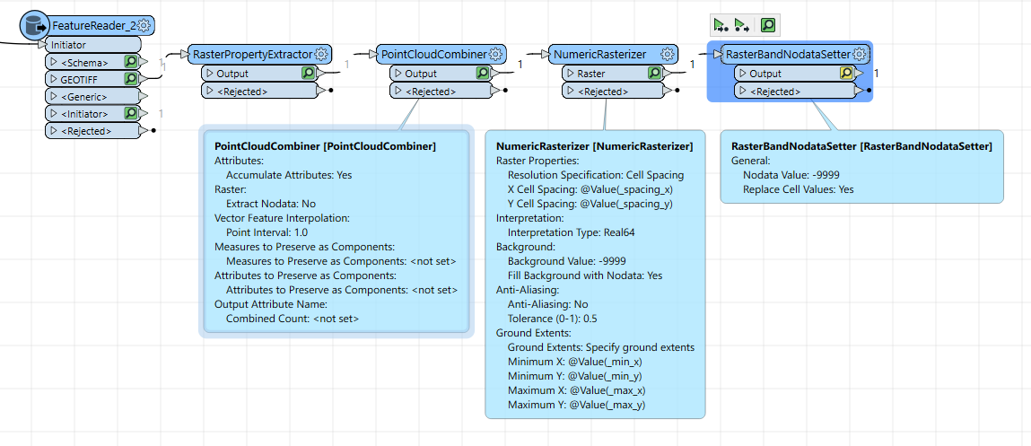
An application. This workflow removes every "nan" point from the source point cloud feature.


By me works well with raster with NaN nan or -nan Nodata value:

  1. RasterPropertyExtractor
  2. PointCloudCombiner with options: Extract NoData = No

  3. NumericRasterizer, set Cell Spacing and extent with the value extracted with RasterPropertyExtractor. Set your nodata value, example -9999


Reply