Solved

SID to GeoTIFF conversion error


fikusas
Contributor
Forum|alt.badge.img+5

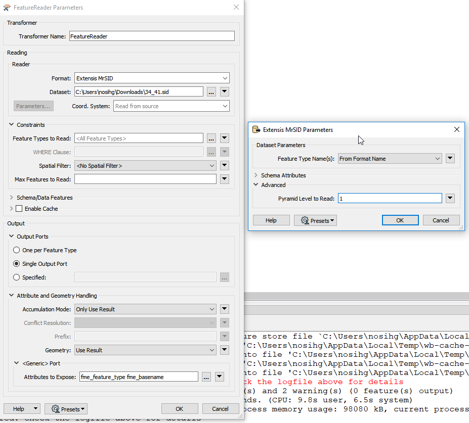
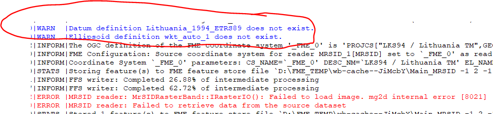
I'm getting the error message then converting SID file to GeoTIFF raster:

MRSID reader: MrSIDRasterBand::IRasterIO(): Failed to load image. mg2d internal error [8021]
MRSID reader: Failed to retrieve data from the source dataset

Any ideas how to solve this?

Best answer by sigtill

You can also read Pyramid layer 1 - instead of default 0 to get this in FME: Then it has the resolution original resolution / 2 = 1m.


View original
Did this help you find an answer to your question?

9 replies

itay
Supporter
Forum|alt.badge.img+17
  • Supporter
  • October 17, 2019

Hi @fikusas,

Can it be that the lack of coordinate system elements (datum and ellipsoid) are causing the issue?


fikusas
Contributor
Forum|alt.badge.img+5
  • Author
  • Contributor
  • October 17, 2019
itay wrote:

Hi @fikusas,

Can it be that the lack of coordinate system elements (datum and ellipsoid) are causing the issue?

I think it can't be a problem, 'cause all other SID files aren't with defined coordsys either, but don't give this kind of error.


itay
Supporter
Forum|alt.badge.img+17
  • Supporter
  • October 17, 2019
fikusas wrote:

I think it can't be a problem, 'cause all other SID files aren't with defined coordsys either, but don't give this kind of error.

From what I could find online it seems that some lines in the raster are corrupted. Not a big help but opening with GDAL provides the same error and since FME uses GDAL this is to be expected, so I think the issue is the input raster.


fikusas
Contributor
Forum|alt.badge.img+5
  • Author
  • Contributor
  • October 17, 2019
itay wrote:

From what I could find online it seems that some lines in the raster are corrupted. Not a big help but opening with GDAL provides the same error and since FME uses GDAL this is to be expected, so I think the issue is the input raster.

Maybe the SID file is damaged, thus unreadable...


sigtill
Supporter
Forum|alt.badge.img+24
  • Supporter
  • October 17, 2019

I used Geoviewer from Lizardtech to open the file - free - https://www.extensis.com/support/geoviewer-9

When exporting it seems to give an error

So there is definitely something wrong with a part of the image although it can be viewed partially within the viewer.

I think you have to contact Lizardtech - they might have a MrSIDFix.exe or similar (seem to remember this from way back)


itay
Supporter
Forum|alt.badge.img+17
  • Supporter
  • October 17, 2019
fikusas wrote:

Maybe the SID file is damaged, thus unreadable...

yes that is what I think and @sigtill too..


sigtill
Supporter
Forum|alt.badge.img+24
  • Supporter
  • October 17, 2019

Exporting 1m resolution instead of 0.5m resolution works OK. So there is something wrong with the innermost layer. At least you got some of the data :)

Available 1 week, tif can be downloaded here : https://fil.email/ObiRCCUX


sigtill
Supporter
Forum|alt.badge.img+24
  • Supporter
  • Best Answer
  • October 17, 2019

You can also read Pyramid layer 1 - instead of default 0 to get this in FME: Then it has the resolution original resolution / 2 = 1m.


fikusas
Contributor
Forum|alt.badge.img+5
  • Author
  • Contributor
  • October 17, 2019
sigtill wrote:

You can also read Pyramid layer 1 - instead of default 0 to get this in FME: Then it has the resolution original resolution / 2 = 1m.


Thanks @sigtill !


Cookie policy

We use cookies to enhance and personalize your experience. If you accept you agree to our full cookie policy. Learn more about our cookies.

 
Cookie settings