Solved

using image in pdf moved vector data

  • November 25, 2019
  • 3 replies
  • 13 views

tnarladni
Enthusiast
Forum|alt.badge.img+15

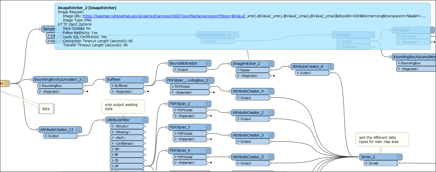
I'm having an issue writing vector data and an image together into a pdf. The vector data is coming from a sql database, the image is from a web source. I'm using the ImageFetcher to clip the piece of image I need. The bounding box of the image comes from a buffered of all the vector data I'm writing to the pdf layer.

The vector data are pushed off into the corner when I attempt to write both the image and the vector together. I'm following the example of how to create the pdf from a sample workflow from Safe. The only difference is that the image in the sample comes from a file and mine comes from a web source.

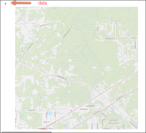
Would appreciate help with this. Below are the workspace image, and the image of the pdf with and without the background image.

Best answer by tnarladni

Found the solution. For whatever reason, the ImageFetcher does not honor the coordinates of the WMS call. The size is correct, but the coordinates are off. So I'm using the RasterGeoreferencer to put the image into the correct location (I used the BoundExtractor first). Incidentally, i'm using the output from the BoundExtractor to get the correct window for the image, but those coordinates are replaced by some random coordinates.

View original
Did this help you find an answer to your question?

3 replies

erik_jan
Contributor
Forum|alt.badge.img+17
  • Contributor
  • November 25, 2019

It appears like the 2 data sets (image and vector data) are not in the same coordinate system).

In that case you will need to use a Reprojector transformer to get them in the same coordinate system.

Hope this helps.


tnarladni
Enthusiast
Forum|alt.badge.img+15
  • Author
  • Enthusiast
  • November 25, 2019
erik_jan wrote:

It appears like the 2 data sets (image and vector data) are not in the same coordinate system).

In that case you will need to use a Reprojector transformer to get them in the same coordinate system.

Hope this helps.

In the ImageFetcher, I am specifying the coordinate system of the output image which is the same coordinate system as my vector data. I also selected the lat/long of one of the vertices of the data and in the inspector of the image, that point is within the image.

tnarladni
Enthusiast
Forum|alt.badge.img+15
  • Author
  • Enthusiast
  • Best Answer
  • November 26, 2019

Found the solution. For whatever reason, the ImageFetcher does not honor the coordinates of the WMS call. The size is correct, but the coordinates are off. So I'm using the RasterGeoreferencer to put the image into the correct location (I used the BoundExtractor first). Incidentally, i'm using the output from the BoundExtractor to get the correct window for the image, but those coordinates are replaced by some random coordinates.


Cookie policy

We use cookies to enhance and personalize your experience. If you accept you agree to our full cookie policy. Learn more about our cookies.

 
Cookie settings