Solved

Only loading in Raster data based on Area of Interest (from a GeometryReplacer and User Parameters)


joku041199
Contributor
Forum|alt.badge.img+4

Hello, 

I am using FME 2022.2 and I’m trying to load in Raster data, based on an Area of Interest (AOI), specified by the end-user in FME Server (yes my organization is not using FME Flow yet, but the old FME Server). 

We have a few big Raster datasets on a local drive (of the entire Netherlands), which are loaded in as regular Readers. Then, using a Creator and GeometryReplacer, the end-user can specify an AOI (using a User Parameter), and the Rasters are then clipped in the Workspace using a Clipper. However, this means that the big Raster datasets need to be loaded/processed every single time the Workspace is ran, which is bad for performance. 

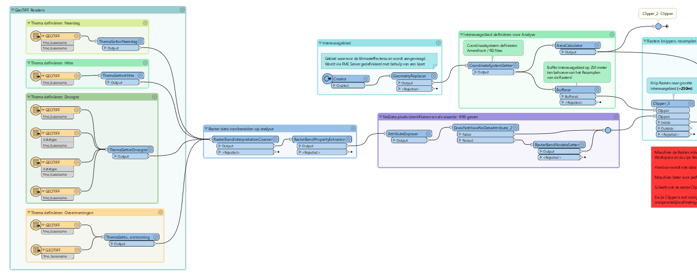
What I want, is that the Raster data is loaded into the Workspace, but only the data which intersects the AOI, specified by the end-user. 

I tried using a FeatureReader and use the AOI from the end-user as trigger to load in the Raster data. However, for some reason, the entire Raster dataset is loaded every time, instead of only the Raster data intersecting the AOI. I guess the FeatureReader is not friends with Raster data...

I cannot find a way to do this, any ideas? Thanks in advance :)

Best answer by david_r

What I’ve done in the past is to pre-process the rasters and generete BBOXes for each raster tile, e.g. using the BoundingBoxReplacer. Then I saved these BBOX polygons in a vector dataset with the raster tile filename as an attribute. This dataset remains (fairly) static.

When a user wanted rasters for a given polygon, I would overlay the user polygon with the BBOX polygons to isolate which tiles to deliver. This is much faster than reading the entire raster contents, especially for larger areas.

View original
Did this help you find an answer to your question?

2 replies

david_r
Celebrity
  • Best Answer
  • August 30, 2024

What I’ve done in the past is to pre-process the rasters and generete BBOXes for each raster tile, e.g. using the BoundingBoxReplacer. Then I saved these BBOX polygons in a vector dataset with the raster tile filename as an attribute. This dataset remains (fairly) static.

When a user wanted rasters for a given polygon, I would overlay the user polygon with the BBOX polygons to isolate which tiles to deliver. This is much faster than reading the entire raster contents, especially for larger areas.


redgeographics
Celebrity
Forum|alt.badge.img+49

FeatureReader doesn’t clip raster, so what I usually do is use the FeatureReader with the option Bounding Boxes Intersect and then what comes out of that I clip to the area coming out of the GeometryReplacer, using a Clipper.


Cookie policy

We use cookies to enhance and personalize your experience. If you accept you agree to our full cookie policy. Learn more about our cookies.

 
Cookie settings