Question

Convert Oracle datasets to different geopackages


fme_dr22_forum
Contributor
Forum|alt.badge.img+4

My question is about the following: I want to create Geopackages from about 20 Oracle spatial datasets. Each dataset must be stored in a separate geopackage.

For Example: Oracle dataset 1 must become Geopackage 1, Oracle dataset 2 must become Geopackage 2.  The names from the Oracle dataset must also be copied into the Geopackage.In addition, each Geopackage must be zipped.

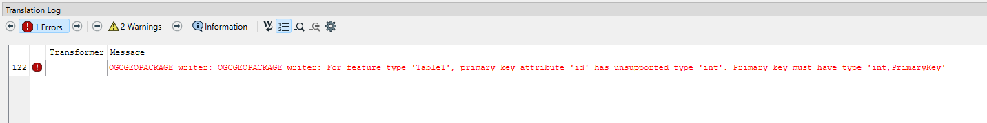
Is there a way to automate this in FME? I was already thinking about the AttributeExposer, but I can't get it to work.

Thank you in advance.

5 replies

donalmateer
Safer
Forum|alt.badge.img+6

Hi @fme_dr22_forum,

Thank you for the question! Appreciate it!

If you're looking for a way to automate converting oracle datasets to different geopackages there is a number of ways of doing this.

The best way to go about this would be to use an AttributeExposer (used to make the 'fme_feature_type' attribute visible), then use a AttributeManager (create a new attribute 'output_path', this will define the output file path for each GeoPackage. e.g. /geoPacakge/@Value(fme_feature_type).

Finally implementing a Dataset Fanout (using 'FeatureTypeFanout' on the 'output_path'it instructs FME to create a separate GeoPackage for each unique value of 'output_path').

This article may also be of use to you - Setting Dataset Fanout
Hope this helps! 

Donal.


liamfez
Influencer
Forum|alt.badge.img+34
  • Influencer
  • July 11, 2024

Adding the documentation for zipping to go along with the documentation for dataset fanout already provided.

https://docs.safe.com/fme/html/FME-Form-Documentation/FME-Form/Workbench/zip_files_writing.htm


fme_dr22_forum
Contributor
Forum|alt.badge.img+4

Thank you for your answers. I'm busy with some other things now. When I'm ready, I'll try out your tips.


fme_dr22_forum
Contributor
Forum|alt.badge.img+4
donalmateer wrote:

Hi @fme_dr22_forum,

Thank you for the question! Appreciate it!

If you're looking for a way to automate converting oracle datasets to different geopackages there is a number of ways of doing this.

The best way to go about this would be to use an AttributeExposer (used to make the 'fme_feature_type' attribute visible), then use a AttributeManager (create a new attribute 'output_path', this will define the output file path for each GeoPackage. e.g. /geoPacakge/@Value(fme_feature_type).

Finally implementing a Dataset Fanout (using 'FeatureTypeFanout' on the 'output_path'it instructs FME to create a separate GeoPackage for each unique value of 'output_path').

This article may also be of use to you - Setting Dataset Fanout
Hope this helps! 

Donal.


Good afternoon @donalmateer,Your solution works fine. Unfortunately I get the following error message. FME indicates that the id has an unsupported type 'int'. The Primary key must have type 'int,Primarykey. 
Now I also came across this topic and I read that it may have to do with a BUG (https://community.safe.com/data-7/ogcgeopackage-writer-primary-key-attribute-id-has- unsupported-type-mediumint-18679) .Do you have any idea how I can get around this problem? If I remove the ID in the writer (manually), everything works fine. The point is, I need the ID. I tried making the ID the data type mediumint. Unfortunately this didn't help either.
Kind regards, Wim 

fme_dr22_forum
Contributor
Forum|alt.badge.img+4


I also have the following general question. It would also be nice if I received the appropriate attribute tables for each Geopackage. Now I receive all attribute tables of all datasets. The attribute tables that do not belong to the specific dataset are then not filled.


Is there a way to make this neater so that you only see the attribute tables that belong to the specific dataset?


Cookie policy

We use cookies to enhance and personalize your experience. If you accept you agree to our full cookie policy. Learn more about our cookies.

 
Cookie settings