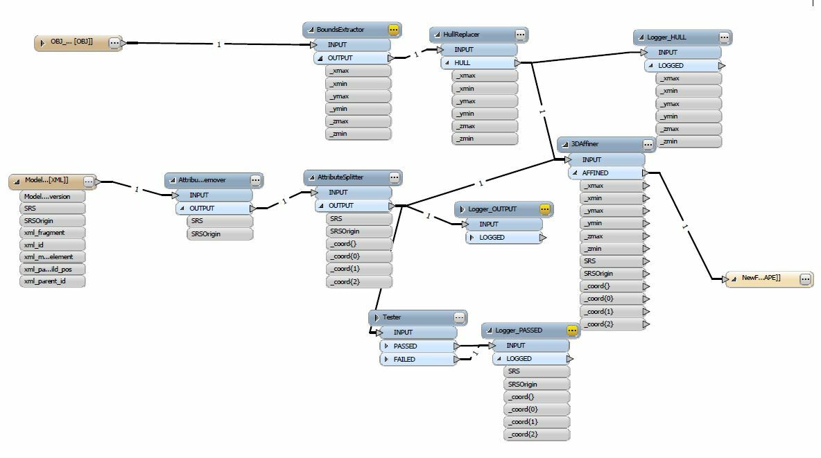
Let me explain what I want to do: I have a ".obj" file, and a ".xml" file which contains some metadata. The coordinates in the ".obj" file are in a local reference frame. Thus, to get them in a projected SRS, I need to translate them using some values that I can parse in the ".xml" file. What I want to do is:
- Read ".obj" and ".xml" file
- Compute convex (concave) hull of the geometries in the ".obj" file
- Translate the hull with values read from the ".xml" file
- Save the translated geometry in a ".shp" and force its EPSG with a value read in the ".xml" file
To do the translation, here is what I do:
- Read ".obj" and ".xml" files
- Remove unused attributes (optional)
- Split the SRSOrigin attribute with an AttributeSplitter in a _coord list ("," separator and expose 3 _coords elements
- Use a StringFormatter to convert _coord{} elements to floating point values (format string: f)
- Use a 3DAffiner on the output of a HullReplacer with A=_coord{0}, F=_coord{1} and K=_coord{2} (all other elements to 0)
3DAffiner: Unable to convert @Affine parameter A value `' to a floating point value
If I use a logger on the StringFormatter, here is what I get:
Attribute(encoded: utf-16): `SRS' has value `EPSG:2154'
Attribute(encoded: utf-16): `SRSOrigin' has value `652367,6862971,0'
Attribute(32 bit integer) : `Source Brancher 0.BranchingFactory.Count' has value `1'
Attribute(32 bit integer) : `Source Feature Router.BranchingFactory.Count' has value `1'
Attribute(encoded: utf-8) : `_coord{0}' has value `652367.000000'
Attribute(encoded: utf-8) : `_coord{1}' has value `6862971.000000'
Attribute(encoded: utf-8) : `_coord{2}' has value `0.000000'
To me, it seems that _coord list elements are not well converted to floating point values ("encoded: utf-8").
Could you please help me on how to fix the problem?
And please, could you also tell me how to force output EPSG to the oneread in the ".xml" file?
Hope you could help.
Best regards
Olivier


