Hi everyone,


I have some DEMs. I combined them (PointCloudCombiner) and have created surfaces on them (PointCloudSurfaceBuilder) and exported them as LandXML. 

The problem is with the borders of the DEMs. They are not connected. How can I solve it?

Thanks!
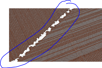
 

I’m not sure if I understand correctly. Do the original DEM’s overlap? Did you loose data? Or you have no coverage in this area to start with?


Hi,

Thanks for your reply.

They do not overlap and I have not missed any data. Only after Combination and creating the surface, it is like that.


So you want to fill the gap with interpolated values? I am no expert on this but have done something similair with elevationrasters. What I did roughly was:

  • Identify the locations of the gaps.
    • This depends on your data, but tools I can think of are HullAccumulators (when using pointclouds, coerce the pointcloud to single multipoint first) and Clippers to get an area where the gap need to be filled.
  • Use a DEMGenerator to interpolate the data.
  • Clipper to use the result and the gap area to keep only the interpolated points.
  • And then feed your original data and the interpolated points in the PointCloudSurfaceBuilder.

Reply